 view gallery view gallery W11.1 km W11.1 km
|   Kareela, Thunderbolts Way, NSW Kareela, Thunderbolts Way, NSW
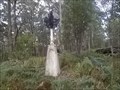
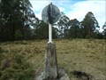
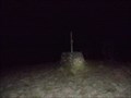
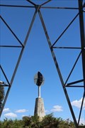
in Australian Trig Points This concrete pedestal trig is not far from the Thunderbolts Way, but is not visible from 'anywhere'.
Official Code: TS5668 posted by:  Grahame Cookie Grahame Cookie location: New South Wales, Australia date approved: 05/24/2015 last visited: never |
 view gallery view gallery S25.4 km S25.4 km
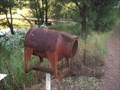
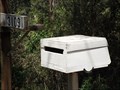
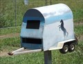
|  Cow Letterbox - Tibbuc, NSW, Australia Cow Letterbox - Tibbuc, NSW, Australia
in Themed Homemade Mailboxes This Homemade Themed Letterbox is right beside Thunderbolts Way, north of Barrington. posted by: Grahame Cookie location: New South Wales, Australia date approved: 02/15/2019 last visited: never |
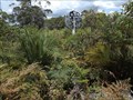
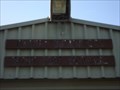 view gallery view galleryS28.2 km |  Tibbuc Volunteer Bush Fire Brigade Tibbuc Volunteer Bush Fire Brigade
in Firehouses This is the volunteer Fire Brigade for the rural community of Tibbuc. posted by: Grahame Cookie location: New South Wales, Australia date approved: 02/10/2019 last visited: never |
 view gallery view gallery E28.6 km E28.6 km
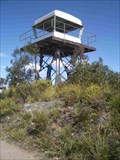
| Kaoaraoa in Australian Trig Points This Trig has a fire tower built on top. It's in a great area of State Forest and National Parks, accessible by 2wd. posted by: *socks* location: New South Wales, Australia date approved: 10/27/2008 last visited: 10/24/2014 |
 view gallery view gallery SE29.1 km SE29.1 km
| Knorrit Flat Riverside Retreat, Caffreys Flat, NSW, Australia in Themed Homemade Mailboxes This caravan shaped letterbox is very appropriate for the Knorrit Flat Riverside Retreat, at 3109 Nowendoc Rd, Caffreys Flat, NSW, 2424. posted by: Grahame Cookie location: New South Wales, Australia date approved: 12/03/2015 last visited: never |
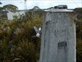
 view gallery view gallerySE32 km | Pinanpinga TP, Knodingbul Forest, NSW in Australian Trig Points This is a concrete pedestal trig, with plastic post, and what were black semi-circular vanes (but basically all the paint has pealed off); no name plate. A 4-Wheel would be an advantage. Otherwise a bit of a walk needed. Official Code: TS6032 posted by: Grahame Cookie location: New South Wales, Australia date approved: 11/16/2015 last visited: never |
 view gallery view gallery NE32.2 km NE32.2 km
| Rushbrook, Plum Tree Hill, NSW in Australian Trig Points Not too far from the Oxley Highway, on the Mid North Coast, this is a concrete pedestal trig with intact post, vanes, and name plate. Access best by 4wd, or walk up the track. Official Code: TS6153 posted by: Grahame Cookie location: New South Wales, Australia date approved: 07/02/2015 last visited: never |
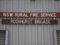 view gallery view galleryS32.8 km | Rookhurst Brigade in Firehouses This is the local volunteer Fire Brigade for the rural community of Rookhurst. posted by: Grahame Cookie location: New South Wales, Australia date approved: 02/10/2019 last visited: never |
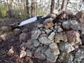
 view gallery view gallery N33.5 km N33.5 km
| Dennes, Great Dividing Range, NSW in Australian Trig Points Dennes trig is JUST outside of the Mummel Gulf National Park, south of Oxley Highway, NSW. It is a well constructed rock cairn, with wooden pole. Official Code: TS1806 posted by: Grahame Cookie location: New South Wales, Australia date approved: 11/29/2014 last visited: never |
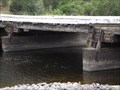 view gallery view gallerySE34.6 km |  Manning River, "Tiri Creek", NSW, Australia Manning River, "Tiri Creek", NSW, Australia
in Plank Roads Situated over the delightful Manning River at Tiri Creek is this low level, log beam, multi-span wooden bridge. Local hard wood is used for the spanning logs (unsawn) as well as the surface boards. posted by: Grahame Cookie location: New South Wales, Australia date approved: 11/26/2015 last visited: never |
 view gallery view galleryN35.7 km | Porters, Mummel Gulf NP, NSW in Australian Trig Points Previously called Great Dividing Range Area on GCA, actually has nameplate of Porters. Behind the enclosed radio towers. Official Code: TS5651 posted by: Grahame Cookie location: New South Wales, Australia date approved: 11/29/2014 last visited: never |
 view gallery view gallery NW36.4 km NW36.4 km
| Grundy GS, Riamukka Area/Walcha, NSW in Australian Trig Points Set right near the Grundy fire look out tower is this concrete pedestal trig, in the Riamukka Area. Official Code: TS5648; Elevation of 1463 metres. posted by: Grahame Cookie location: New South Wales, Australia date approved: 10/25/2016 last visited: never |
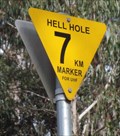 view gallery view galleryNW36.9 km |  Hell Hole, 7km Marker, Riamukka Area, NSW, Australia Hell Hole, 7km Marker, Riamukka Area, NSW, Australia
in Man-made Devilish Locations On the WINDY road to "Hell Hole" up on the "Great Dividing Range" of New South Wales, there are signs each kilometre reminding the driver to use their UHF radio, and gives a reference for them to use in warning the logging trucks. posted by: Grahame Cookie location: New South Wales, Australia date approved: 07/14/2015 last visited: never |
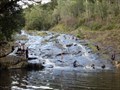 view gallery view galleryE37.2 km |  Ellenborough River Cascades - Elands, NSW, Australia Ellenborough River Cascades - Elands, NSW, Australia
in Waterfalls This is a lovely rocky Cascade just a few kilometres above the majestic Ellenborough Falls. posted by: Grahame Cookie location: New South Wales, Australia date approved: 03/31/2024 last visited: never |
 view gallery view gallerySE37.7 km | Dingo Peak, Knorrit Forest, NSW in Australian Trig Points This stone cairn trig stands at 744 m on top of a rocky steep hill with no track access from where you park the geoburra. An attempt has been made to rejuvenate the trig recently - unsuccessfully (partly). Official Code: TS1831, Name: Dingo. posted by: Grahame Cookie location: New South Wales, Australia date approved: 07/02/2015 last visited: never |
![Image for Ellenborough Falls [NSW, Australia]](https://img.geocaching.com/waymarking/small/1a81b5b3-da15-432c-82bf-633e1852498e.jpg) view gallery view galleryE39.4 km |  Ellenborough Falls [NSW, Australia] Ellenborough Falls [NSW, Australia]
in Wikipedia Entries This horsetail waterfall flows over the Bulga Plateau at Elands. posted by: Grahame Cookie location: New South Wales, Australia date approved: 03/25/2024 last visited: never |
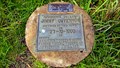 view gallery view galleryE39.8 km |  Capture of Jimmy Governor - Wingham, NSW Capture of Jimmy Governor - Wingham, NSW
in Australian Historical Markers This marker is to be found alongside Bobin Creek Road about 26 km. north northwest of the town of Wingham in NSW. posted by: T0SHEA location: New South Wales, Australia date approved: 12/29/2014 last visited: 01/07/2015 |
 view gallery view galleryNW39.9 km | Flags Trig near Nowendoc State Forest NSW in Australian Trig Points Flags Trig is on Black Sugarloaf Mountain at 1400 m elevation. Official Code: TS6069 posted by:  John1041 John1041 location: New South Wales, Australia date approved: 11/11/2018 last visited: 12/17/2018 |
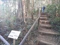
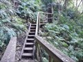 view gallery view galleryE40.1 km |  Ellenborough Falls, Base - Elands, NSW, Australia Ellenborough Falls, Base - Elands, NSW, Australia
in Outdoor Stairways The base of Ellenborough Falls is some 200m below the head of the horsetail waterfall. posted by: Grahame Cookie location: New South Wales, Australia date approved: 03/31/2024 last visited: never |
 view gallery view gallerySE40.1 km | Horse Float, Knodingbul Rd, Mt George, NSW, Australia in Themed Homemade Mailboxes Not far from Nowendoc Road, west of Mount George, on Knodingbul Road, is this horse float letterbox. posted by: Grahame Cookie location: New South Wales, Australia date approved: 02/04/2017 last visited: never |
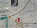 view gallery view galleryE40.2 km |  Ellenborough Falls - You are here - Elands, NSW, Australia Ellenborough Falls - You are here - Elands, NSW, Australia
in 'You Are Here' Maps This information sign near the car park shows where you are at the trails of Ellenborough Falls. posted by: Grahame Cookie location: New South Wales, Australia date approved: 03/31/2024 last visited: never |
 view gallery view galleryE40.2 km |  Ellenborough Falls Lookout - Elands, NSW, Australia Ellenborough Falls Lookout - Elands, NSW, Australia
in Scenic Roadside Look-Outs A pleasant country drive onto the Bulga Plateau will get you to a simple ramp to the Falls Ellenborough Lookout. posted by: Grahame Cookie location: New South Wales, Australia date approved: 04/01/2024 last visited: never |
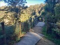
 view gallery view galleryE40.2 km |  The Knoll - Ellenborough Falls - Elands, NSW, Australia The Knoll - Ellenborough Falls - Elands, NSW, Australia
in Hiking and walking trailheads This dirt path divides to give the option of 'Bottom of the Falls', or 'The Knoll' outlook. posted by: Grahame Cookie location: New South Wales, Australia date approved: 03/30/2024 last visited: never |
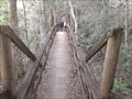 view gallery view galleryE40.2 km |  Ellenborough Falls/The Knoll Lookout - Elands, NSW, Australia Ellenborough Falls/The Knoll Lookout - Elands, NSW, Australia
in Hiking Path Footbridges This wooden footbridge gives access to the Knoll Lookout to the Ellenborough Falls. posted by: Grahame Cookie location: New South Wales, Australia date approved: 04/10/2024 last visited: never |
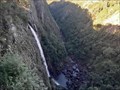 view gallery view galleryE40.2 km | Ellenborough Falls - Elands, NSW, Australia in Waterfalls This spectacular Waterfall is a little off the regular 'track', but worth it!! posted by: Grahame Cookie location: New South Wales, Australia date approved: 03/21/2024 last visited: never |
|