 view gallery view gallery W4 km W4 km
|   Rushbrook, Plum Tree Hill, NSW Rushbrook, Plum Tree Hill, NSW
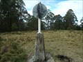
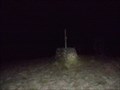
in Australian Trig Points Not too far from the Oxley Highway, on the Mid North Coast, this is a concrete pedestal trig with intact post, vanes, and name plate. Access best by 4wd, or walk up the track. Official Code: TS6153 posted by:  Grahame Cookie Grahame Cookie location: New South Wales, Australia date approved: 07/02/2015 last visited: never |
 view gallery view gallery NW18.5 km NW18.5 km
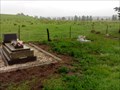
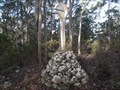
|  Yarrowitch Church, NSW, Australia Yarrowitch Church, NSW, Australia
in Churchyard Cemeteries The small country Church in the locality of Yarrowitch has a few headstones out the back. posted by: Grahame Cookie location: New South Wales, Australia date approved: 11/14/2016 last visited: never |
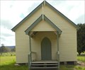 view gallery view galleryNW18.7 km |  Yarrowitch, NSW, Australia Yarrowitch, NSW, Australia
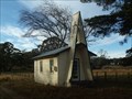
in Country Churches This quaint church is at the locality of Yarrowitch, just off of the Oxley Highway, about 48 km east of Walcha. posted by: Grahame Cookie location: New South Wales, Australia date approved: 11/09/2016 last visited: never |
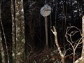
 view gallery view galleryW22 km | Porters, Mummel Gulf NP, NSW in Australian Trig Points Previously called Great Dividing Range Area on GCA, actually has nameplate of Porters. Behind the enclosed radio towers. Official Code: TS5651 posted by: Grahame Cookie location: New South Wales, Australia date approved: 11/29/2014 last visited: never |
 view gallery view galleryW24.9 km | Dennes, Great Dividing Range, NSW in Australian Trig Points Dennes trig is JUST outside of the Mummel Gulf National Park, south of Oxley Highway, NSW. It is a well constructed rock cairn, with wooden pole. Official Code: TS1806 posted by: Grahame Cookie location: New South Wales, Australia date approved: 11/29/2014 last visited: never |
 view gallery view gallery NE26.7 km NE26.7 km
| Melville trig, Yarrowitch, NSW in Australian Trig Points About a kilometre west of Racecourse Trail (or Youdales Trail), in the Werrikimbe NP and Yarrowitch regions is this rock cairn trig.
Official code: TS3054. Elevation: +/- 1,050 metres. posted by: Grahame Cookie location: New South Wales, Australia date approved: 11/24/2016 last visited: never |
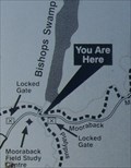 view gallery view galleryNE26.7 km |  URHere, Platypus Pools Walk, Werrikimbe NP, NSW, Australia URHere, Platypus Pools Walk, Werrikimbe NP, NSW, Australia
in 'You Are Here' Maps Just over the rise of the Mooraback Camping area, in the Werrikimbe National Park (below the Service Hut), is the start of the Platypus Pools Walk. Keep your eyes open for kangaroos as well. posted by: Grahame Cookie location: New South Wales, Australia date approved: 03/21/2016 last visited: never |
 view gallery view gallery S27.2 km S27.2 km
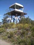
| Kaoaraoa in Australian Trig Points This Trig has a fire tower built on top. It's in a great area of State Forest and National Parks, accessible by 2wd. posted by: *socks* location: New South Wales, Australia date approved: 10/27/2008 last visited: 10/24/2014 |
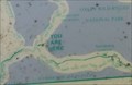 view gallery view galleryNE31.2 km | Kunderang Wilderness UR Here, Werrikimbe NP, NSW, Australia in 'You Are Here' Maps At the junction of Racecourse Trail, and Youdales West Trail, is a dilapidated map from the National Parks and Wildlife Service, showing where you are in the Kunderang Wilderness - Werrikimbe National Park. posted by: Grahame Cookie location: New South Wales, Australia date approved: 10/24/2016 last visited: never |
 view gallery view galleryNE31.5 km | Drain trig, Kunderang Wilderness Area, Werrikimbe, NSW in Australian Trig Points Situated not far off a dirt track leading into the Kunderang Wilderness Area, on the northern part of the Werrikimbe National Park is this concrete pedestal trig, with intact post, vanes, and name plate. Official Code: TS6304 posted by: Grahame Cookie location: New South Wales, Australia date approved: 11/16/2015 last visited: never |
 view gallery view gallery SE32.7 km SE32.7 km
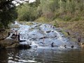
|  Ellenborough River Cascades - Elands, NSW, Australia Ellenborough River Cascades - Elands, NSW, Australia
in Waterfalls This is a lovely rocky Cascade just a few kilometres above the majestic Ellenborough Falls. posted by: Grahame Cookie location: New South Wales, Australia date approved: 03/31/2024 last visited: never |
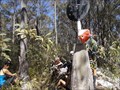
 view gallery view galleryNE35.1 km | Boss TP, Bingleburra, NSW in Australian Trig Points Official Code: TS1096
This old stone cairn trig won't be able to be seen from anywhere so thick is the growth around it. About a half hour walk / bushbash required from the intersection of Rimau Rd & Forbes Rd, in the Werrikimbe National Park. posted by: Grahame Cookie location: New South Wales, Australia date approved: 05/25/2015 last visited: never |
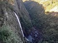
![Image for Ellenborough Falls [NSW, Australia]](https://img.geocaching.com/waymarking/small/1a81b5b3-da15-432c-82bf-633e1852498e.jpg) view gallery view gallerySE36.2 km |  Ellenborough Falls [NSW, Australia] Ellenborough Falls [NSW, Australia]
in Wikipedia Entries This horsetail waterfall flows over the Bulga Plateau at Elands. posted by: Grahame Cookie location: New South Wales, Australia date approved: 03/25/2024 last visited: never |
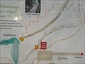 view gallery view gallerySE36.2 km | Ellenborough Falls - You are here - Elands, NSW, Australia in 'You Are Here' Maps This information sign near the car park shows where you are at the trails of Ellenborough Falls. posted by: Grahame Cookie location: New South Wales, Australia date approved: 03/31/2024 last visited: never |
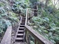 view gallery view gallerySE36.2 km |  Ellenborough Falls, Base - Elands, NSW, Australia Ellenborough Falls, Base - Elands, NSW, Australia
in Outdoor Stairways The base of Ellenborough Falls is some 200m below the head of the horsetail waterfall. posted by: Grahame Cookie location: New South Wales, Australia date approved: 03/31/2024 last visited: never |
 view gallery view gallerySE36.2 km |  Ellenborough Falls Lookout - Elands, NSW, Australia Ellenborough Falls Lookout - Elands, NSW, Australia
in Scenic Roadside Look-Outs A pleasant country drive onto the Bulga Plateau will get you to a simple ramp to the Falls Ellenborough Lookout. posted by: Grahame Cookie location: New South Wales, Australia date approved: 04/01/2024 last visited: never |
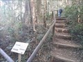 view gallery view gallerySE36.2 km |  The Knoll - Ellenborough Falls - Elands, NSW, Australia The Knoll - Ellenborough Falls - Elands, NSW, Australia
in Hiking and walking trailheads This dirt path divides to give the option of 'Bottom of the Falls', or 'The Knoll' outlook. posted by: Grahame Cookie location: New South Wales, Australia date approved: 03/30/2024 last visited: never |
 view gallery view gallerySE36.2 km | Ellenborough Falls - Elands, NSW, Australia in Waterfalls This spectacular Waterfall is a little off the regular 'track', but worth it!! posted by: Grahame Cookie location: New South Wales, Australia date approved: 03/21/2024 last visited: never |
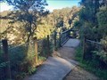
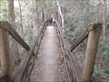 view gallery view gallerySE36.4 km |  Ellenborough Falls/The Knoll Lookout - Elands, NSW, Australia Ellenborough Falls/The Knoll Lookout - Elands, NSW, Australia
in Hiking Path Footbridges This wooden footbridge gives access to the Knoll Lookout to the Ellenborough Falls. posted by: Grahame Cookie location: New South Wales, Australia date approved: 04/10/2024 last visited: never |
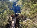 view gallery view gallerySE36.5 km |  Ellenborough Falls/The Knoll Lookout - Elands, NSW, Australia Ellenborough Falls/The Knoll Lookout - Elands, NSW, Australia
in Scenic Overlooks This wood platform is reached by a (T2½) 10 minute walk on a dirt track to this overlook of a great waterfall! posted by: Grahame Cookie location: New South Wales, Australia date approved: 03/21/2024 last visited: never |
 view gallery view gallerySE37.3 km |  Bulga Plateau Rural Fire Brigade Bulga Plateau Rural Fire Brigade
in Firehouses The two buildings are for the volunteer fire fighters of the Elands region of the Bulga Plateau. posted by: Grahame Cookie location: New South Wales, Australia date approved: 03/02/2024 last visited: never |
 view gallery view galleryW38 km | Brackendale, NSW, Australia in Country Churches South of Walcha, on Brackendale Road is this lonely church. posted by: Grahame Cookie location: New South Wales, Australia date approved: 09/25/2015 last visited: never |
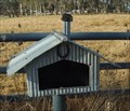 view gallery view galleryNW38 km |  Homestead, Brackendale, NSW, Australia Homestead, Brackendale, NSW, Australia
in Themed Homemade Mailboxes South of Walcha, on Brackendale Rd is this 'corrugated iron' letterbox, styled to look like a homestead. posted by: Grahame Cookie location: New South Wales, Australia date approved: 10/29/2015 last visited: never |
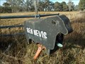 view gallery view galleryNW38 km | Ben Nevis, Brackendale, NSW, Australia in Themed Homemade Mailboxes South of Walcha, almost opposite Lakes Rd on Brackendale Road is this black, beef Angus cattle shaped letter box for the Ben Nevis Angus cattle property. posted by: Grahame Cookie location: New South Wales, Australia date approved: 10/29/2015 last visited: never |
 view gallery view gallery E38.8 km E38.8 km
|  Ellenborough Reserve - Oxley Highway, NSW, Australia Ellenborough Reserve - Oxley Highway, NSW, Australia
in Free Overnight RV Parking Locations Ellenborough Reserve is good for caravans or RVs, with a flat area to park in, just off the Oxley Highway, west of Wauchope. posted by: Grahame Cookie location: New South Wales, Australia date approved: 08/05/2017 last visited: never |
|