 view gallery view gallery SW2.7 km SW2.7 km
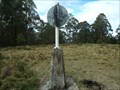
|   Drain trig, Kunderang Wilderness Area, Werrikimbe, NSW Drain trig, Kunderang Wilderness Area, Werrikimbe, NSW
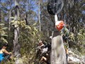
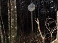
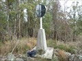
in Australian Trig Points Situated not far off a dirt track leading into the Kunderang Wilderness Area, on the northern part of the Werrikimbe National Park is this concrete pedestal trig, with intact post, vanes, and name plate. Official Code: TS6304 posted by:  Grahame Cookie Grahame Cookie location: New South Wales, Australia date approved: 11/16/2015 last visited: never |
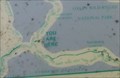 view gallery view gallerySW3.2 km |  Kunderang Wilderness UR Here, Werrikimbe NP, NSW, Australia Kunderang Wilderness UR Here, Werrikimbe NP, NSW, Australia
in 'You Are Here' Maps At the junction of Racecourse Trail, and Youdales West Trail, is a dilapidated map from the National Parks and Wildlife Service, showing where you are in the Kunderang Wilderness - Werrikimbe National Park. posted by: Grahame Cookie location: New South Wales, Australia date approved: 10/24/2016 last visited: never |
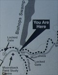 view gallery view gallery S7.7 km S7.7 km
| URHere, Platypus Pools Walk, Werrikimbe NP, NSW, Australia in 'You Are Here' Maps Just over the rise of the Mooraback Camping area, in the Werrikimbe National Park (below the Service Hut), is the start of the Platypus Pools Walk. Keep your eyes open for kangaroos as well. posted by: Grahame Cookie location: New South Wales, Australia date approved: 03/21/2016 last visited: never |
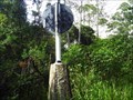
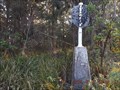
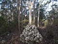 view gallery view gallerySW7.9 km | Melville trig, Yarrowitch, NSW in Australian Trig Points About a kilometre west of Racecourse Trail (or Youdales Trail), in the Werrikimbe NP and Yarrowitch regions is this rock cairn trig.
Official code: TS3054. Elevation: +/- 1,050 metres. posted by: Grahame Cookie location: New South Wales, Australia date approved: 11/24/2016 last visited: never |
 view gallery view gallery SE18.3 km SE18.3 km
| Boss TP, Bingleburra, NSW in Australian Trig Points Official Code: TS1096
This old stone cairn trig won't be able to be seen from anywhere so thick is the growth around it. About a half hour walk / bushbash required from the intersection of Rimau Rd & Forbes Rd, in the Werrikimbe National Park. posted by: Grahame Cookie location: New South Wales, Australia date approved: 05/25/2015 last visited: never |
 view gallery view gallerySE29.5 km | Bellangry trig, Bril Bril, NSW in Australian Trig Points This concrete pedestal trig is on the border between a State Forest, and Willi Willi National Park areas. Official Code: TS6142 posted by: Grahame Cookie location: New South Wales, Australia date approved: 12/18/2016 last visited: never |
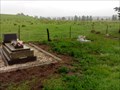 view gallery view gallerySW34.9 km |  Yarrowitch Church, NSW, Australia Yarrowitch Church, NSW, Australia
in Churchyard Cemeteries The small country Church in the locality of Yarrowitch has a few headstones out the back. posted by: Grahame Cookie location: New South Wales, Australia date approved: 11/14/2016 last visited: never |
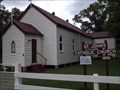
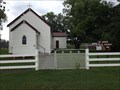
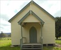 view gallery view gallerySW34.9 km |  Yarrowitch, NSW, Australia Yarrowitch, NSW, Australia
in Country Churches This quaint church is at the locality of Yarrowitch, just off of the Oxley Highway, about 48 km east of Walcha. posted by: Grahame Cookie location: New South Wales, Australia date approved: 11/09/2016 last visited: never |
 view gallery view gallerySW36 km | Rushbrook, Plum Tree Hill, NSW in Australian Trig Points Not too far from the Oxley Highway, on the Mid North Coast, this is a concrete pedestal trig with intact post, vanes, and name plate. Access best by 4wd, or walk up the track. Official Code: TS6153 posted by: Grahame Cookie location: New South Wales, Australia date approved: 07/02/2015 last visited: never |
 view gallery view gallerySE36.2 km | Kogo trig, Upper Rollands Plains, NSW in Australian Trig Points A Four-wheel drive vehicle would be very handy to get to this concrete pedestal trig on top of Kogo Mountain. I would rate access Terrain 4, whether by walking up the steep and rocky track, or by 4wd. Official Code: TS6301 posted by: Grahame Cookie location: New South Wales, Australia date approved: 01/11/2016 last visited: never |
 view gallery view gallery NE39.4 km NE39.4 km
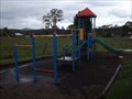
|  Willawarrin, NSW, Australia Willawarrin, NSW, Australia
in Public Playgrounds Just off of Armidale Road, near the sports ground of Willawarrin, is this small children's playground. posted by: Grahame Cookie location: New South Wales, Australia date approved: 03/09/2017 last visited: never |
 view gallery view galleryNE39.6 km | St Johns Catholic Church, Willawarrin, NSW, Australia in This Old Church Right beside the Armidale Road, as it goes through the small town of Willawarrin is the old Catholic Church, built in 1896, while most of the old buildings have gone, this has stayed. posted by: Grahame Cookie location: New South Wales, Australia date approved: 03/14/2016 last visited: never |
 view gallery view galleryNE39.6 km | St Johns - Willawarrin, NSW, Australia in Roman Catholic Churches Willawarrin was a common stopping point for travellers going from the coast to the New England highlands over a hundred years ago; and St Johns Catholic Church was built in 1896 for what was a flourishing community. posted by: Grahame Cookie location: New South Wales, Australia date approved: 03/14/2016 last visited: never |
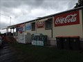
 view gallery view galleryNE39.6 km |  Willawarrin, NSW, Australia Willawarrin, NSW, Australia
in The Local Neighborhood Grocer Willawarrin is not my local grocer, but it is all that the locals have for about 80 km. So it is well used. A great place to stop for some refreshments. posted by: Grahame Cookie location: New South Wales, Australia date approved: 12/06/2015 last visited: never |
 view gallery view galleryNE39.6 km |  Willawarrin, NSW - 2440 Willawarrin, NSW - 2440
in Australia Post Offices This Post Office branch is in the general store of the locality of Willawarrin. posted by: Grahame Cookie location: New South Wales, Australia date approved: 12/01/2015 last visited: never |
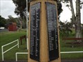
 view gallery view galleryNE39.8 km |  Willawarrin WW2 'obelisk', NSW, Australia Willawarrin WW2 'obelisk', NSW, Australia
in World War II Memorials / Monuments This short concrete column has been painted a 'cream colour', and has two long (tall) black granite plaques attached, for those that served in World War Two from the Willawarrin district, NSW. posted by: Grahame Cookie location: New South Wales, Australia date approved: 04/02/2017 last visited: never |
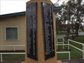
 view gallery view galleryNE39.8 km |  Willawarrin, NSW, Australia Willawarrin, NSW, Australia
in World War I Memorials and Monuments This concrete column has been painted a 'cream colour', and has two long (tall) black granite plaques attached, for those that served in World War One from the Willawarrin district, NSW. posted by: Grahame Cookie location: New South Wales, Australia date approved: 03/04/2017 last visited: never |
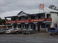 view gallery view galleryNE39.8 km |  Willawarrin Hotel, NSW, Australia Willawarrin Hotel, NSW, Australia
in Pubs and Inns Just beside the Kempsey to Armidale Road is this great country hotel, in beautiful country surroundings. posted by: Grahame Cookie location: New South Wales, Australia date approved: 03/04/2017 last visited: never |
 view gallery view gallery E42 km E42 km
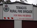
|  Temagog Rural Fire Brigade Temagog Rural Fire Brigade
in Firehouses The Temagog Rural Fire Brigade has their shed right beside the Kempsey-Armidale Road. posted by: Grahame Cookie location: New South Wales, Australia date approved: 04/04/2017 last visited: never |
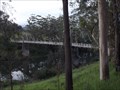 view gallery view gallerySE43.3 km |  Kindee Bridge, Kindee, NSW, Australia Kindee Bridge, Kindee, NSW, Australia
in Suspension Bridges This is a BEAUTIFUL specimen of a wooden suspension bridge over the Hastings River. posted by: Grahame Cookie location: New South Wales, Australia date approved: 05/20/2017 last visited: never |
 view gallery view gallerySW43.9 km | Porters, Mummel Gulf NP, NSW in Australian Trig Points Previously called Great Dividing Range Area on GCA, actually has nameplate of Porters. Behind the enclosed radio towers. Official Code: TS5651 posted by: Grahame Cookie location: New South Wales, Australia date approved: 11/29/2014 last visited: never |
 view gallery view gallerySE43.9 km | Albert trig, Kindee, NSW in Australian Trig Points This is a concrete pedestal with intact post and vanes, even with a name plate. Official Code: TS6141 - Name: Albert. There is also an old rock cairn beside it. posted by: Grahame Cookie location: New South Wales, Australia date approved: 10/17/2015 last visited: never |
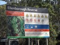 view gallery view gallerySE44.7 km |  Ellenborough Reserve - Oxley Highway, NSW, Australia Ellenborough Reserve - Oxley Highway, NSW, Australia
in Free Campsites Ellenborough Reserve is good for camping and tenting, with a flat area to pitch your tent in, just off the Oxley Highway, west of Wauchope. posted by: Grahame Cookie location: New South Wales, Australia date approved: 08/05/2017 last visited: never |
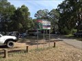 view gallery view gallerySE44.7 km |  Ellenborough Reserve - Oxley Highway, NSW, Australia Ellenborough Reserve - Oxley Highway, NSW, Australia
in Free Overnight RV Parking Locations Ellenborough Reserve is good for caravans or RVs, with a flat area to park in, just off the Oxley Highway, west of Wauchope. posted by: Grahame Cookie location: New South Wales, Australia date approved: 08/05/2017 last visited: never |
 view gallery view gallerySE45.1 km |  Happy Frog - Ellenborough, NSW, Australia Happy Frog - Ellenborough, NSW, Australia
in Themed Homemade Mailboxes An LPG bottle has been made into one Happy Frog, and used as a letterbox in the rural community of Ellenborough, in the Hastings Valley. posted by: Grahame Cookie location: New South Wales, Australia date approved: 07/21/2017 last visited: never |
|