 view gallery view gallery SE12.7 km SE12.7 km
|   Kunderang Wilderness UR Here, Werrikimbe NP, NSW, Australia Kunderang Wilderness UR Here, Werrikimbe NP, NSW, Australia
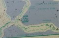
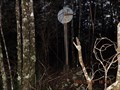
in 'You Are Here' Maps At the junction of Racecourse Trail, and Youdales West Trail, is a dilapidated map from the National Parks and Wildlife Service, showing where you are in the Kunderang Wilderness - Werrikimbe National Park. posted by:  Grahame Cookie Grahame Cookie location: New South Wales, Australia date approved: 10/24/2016 last visited: never |
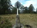
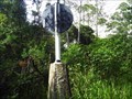
 view gallery view gallerySE12.7 km |  Drain trig, Kunderang Wilderness Area, Werrikimbe, NSW Drain trig, Kunderang Wilderness Area, Werrikimbe, NSW
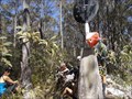
in Australian Trig Points Situated not far off a dirt track leading into the Kunderang Wilderness Area, on the northern part of the Werrikimbe National Park is this concrete pedestal trig, with intact post, vanes, and name plate. Official Code: TS6304 posted by: Grahame Cookie location: New South Wales, Australia date approved: 11/16/2015 last visited: never |
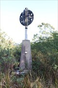
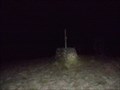
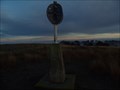
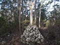 view gallery view gallerySE12.9 km | Melville trig, Yarrowitch, NSW in Australian Trig Points About a kilometre west of Racecourse Trail (or Youdales Trail), in the Werrikimbe NP and Yarrowitch regions is this rock cairn trig.
Official code: TS3054. Elevation: +/- 1,050 metres. posted by: Grahame Cookie location: New South Wales, Australia date approved: 11/24/2016 last visited: never |
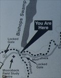 view gallery view gallerySE15.1 km | URHere, Platypus Pools Walk, Werrikimbe NP, NSW, Australia in 'You Are Here' Maps Just over the rise of the Mooraback Camping area, in the Werrikimbe National Park (below the Service Hut), is the start of the Platypus Pools Walk. Keep your eyes open for kangaroos as well. posted by: Grahame Cookie location: New South Wales, Australia date approved: 03/21/2016 last visited: never |
 view gallery view gallery SW29.6 km SW29.6 km
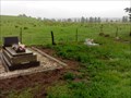
|  Yarrowitch Church, NSW, Australia Yarrowitch Church, NSW, Australia
in Churchyard Cemeteries The small country Church in the locality of Yarrowitch has a few headstones out the back. posted by: Grahame Cookie location: New South Wales, Australia date approved: 11/14/2016 last visited: never |
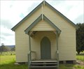 view gallery view gallerySW29.6 km |  Yarrowitch, NSW, Australia Yarrowitch, NSW, Australia
in Country Churches This quaint church is at the locality of Yarrowitch, just off of the Oxley Highway, about 48 km east of Walcha. posted by: Grahame Cookie location: New South Wales, Australia date approved: 11/09/2016 last visited: never |
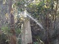
 view gallery view gallerySE30.4 km | Boss TP, Bingleburra, NSW in Australian Trig Points Official Code: TS1096
This old stone cairn trig won't be able to be seen from anywhere so thick is the growth around it. About a half hour walk / bushbash required from the intersection of Rimau Rd & Forbes Rd, in the Werrikimbe National Park. posted by: Grahame Cookie location: New South Wales, Australia date approved: 05/25/2015 last visited: never |
 view gallery view gallery W34.8 km W34.8 km
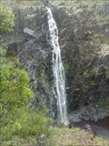
|  Apsley Falls, NSW, Australia Apsley Falls, NSW, Australia
in Waterfalls Apsley Falls are a two-tiered cascade, that drops a total of 123 m, with the longest drop being 65 m. Discovered in 1818 by John Oxley, who named the Apsley River, which descends through a sheer sided gorge. posted by: Grahame Cookie location: New South Wales, Australia date approved: 08/14/2015 last visited: 07/24/2022 |
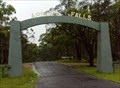 view gallery view galleryW35.9 km |  Apsley Falls, NSW, Australia Apsley Falls, NSW, Australia
in Freestanding Arches This freestanding arch off the Oxley Highway is for the entry road to Apsley Falls, a pair of waterfalls (65 m and 58 m high), about a kilometre away, in the Oxley Wild Rivers National Park. posted by: Grahame Cookie location: New South Wales, Australia date approved: 07/16/2015 last visited: 05/03/2023 |
 view gallery view gallery S36 km S36 km
| Rushbrook, Plum Tree Hill, NSW in Australian Trig Points Not too far from the Oxley Highway, on the Mid North Coast, this is a concrete pedestal trig with intact post, vanes, and name plate. Access best by 4wd, or walk up the track. Official Code: TS6153 posted by: Grahame Cookie location: New South Wales, Australia date approved: 07/02/2015 last visited: never |
 view gallery view gallerySW38.5 km | Porters, Mummel Gulf NP, NSW in Australian Trig Points Previously called Great Dividing Range Area on GCA, actually has nameplate of Porters. Behind the enclosed radio towers. Official Code: TS5651 posted by: Grahame Cookie location: New South Wales, Australia date approved: 11/29/2014 last visited: never |
 view gallery view gallery N38.5 km N38.5 km
| Raspberry Trig - Styx River State Forest NSW in Australian Trig Points An intact Trig point on a 4wd track in the Styx River State Forest. Official COde: TS6380. posted by:  John1041 John1041 location: New South Wales, Australia date approved: 08/19/2018 last visited: 12/16/2018 |
 view gallery view gallerySE41.5 km | Bellangry trig, Bril Bril, NSW in Australian Trig Points This concrete pedestal trig is on the border between a State Forest, and Willi Willi National Park areas. Official Code: TS6142 posted by: Grahame Cookie location: New South Wales, Australia date approved: 12/18/2016 last visited: never |
 view gallery view gallerySW43 km | Dennes, Great Dividing Range, NSW in Australian Trig Points Dennes trig is JUST outside of the Mummel Gulf National Park, south of Oxley Highway, NSW. It is a well constructed rock cairn, with wooden pole. Official Code: TS1806 posted by: Grahame Cookie location: New South Wales, Australia date approved: 11/29/2014 last visited: never |
 view gallery view galleryN46 km | Styx trig - Styx River State Forest, Jeogla, NSW in Australian Trig Points Right beside a dirt road, called Raspberry Road, in the Styx River State Forest, is this concrete pedestal trig. Official Code: TS5827; Official Name: Styx. posted by: Grahame Cookie location: New South Wales, Australia date approved: 03/18/2018 last visited: 08/19/2018 |
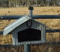 view gallery view gallerySW46.3 km |  Homestead, Brackendale, NSW, Australia Homestead, Brackendale, NSW, Australia
in Themed Homemade Mailboxes South of Walcha, on Brackendale Rd is this 'corrugated iron' letterbox, styled to look like a homestead. posted by: Grahame Cookie location: New South Wales, Australia date approved: 10/29/2015 last visited: never |
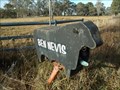 view gallery view gallerySW46.3 km | Ben Nevis, Brackendale, NSW, Australia in Themed Homemade Mailboxes South of Walcha, almost opposite Lakes Rd on Brackendale Road is this black, beef Angus cattle shaped letter box for the Ben Nevis Angus cattle property. posted by: Grahame Cookie location: New South Wales, Australia date approved: 10/29/2015 last visited: never |
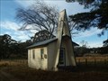 view gallery view gallerySW46.5 km | Brackendale, NSW, Australia in Country Churches South of Walcha, on Brackendale Road is this lonely church. posted by: Grahame Cookie location: New South Wales, Australia date approved: 09/25/2015 last visited: never |
 view gallery view galleryW47 km |  Oxley Rural Fire Brigade Oxley Rural Fire Brigade
in Firehouses This Rural Fire Brigade is another volunteer brigade, south of Walcha, on the Brackendale road. posted by: Grahame Cookie location: New South Wales, Australia date approved: 12/18/2016 last visited: never |
 view gallery view gallery E48.1 km E48.1 km
|  Willawarrin, NSW, Australia Willawarrin, NSW, Australia
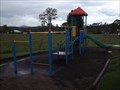
in Public Playgrounds Just off of Armidale Road, near the sports ground of Willawarrin, is this small children's playground. posted by: Grahame Cookie location: New South Wales, Australia date approved: 03/09/2017 last visited: never |
 view gallery view galleryW48.1 km | Walcha GS, Walcha, NSW in Australian Trig Points 'Right' beside Brackendale Road, actually a few hundred metres into the property, is this beautiful, white-painted, concrete pedestal trig, with intact post, vanes and nameplate. Official Code: TS6273 posted by: Grahame Cookie location: New South Wales, Australia date approved: 01/20/2016 last visited: never |
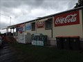
 view gallery view galleryE48.3 km |  Willawarrin, NSW, Australia Willawarrin, NSW, Australia
in The Local Neighborhood Grocer Willawarrin is not my local grocer, but it is all that the locals have for about 80 km. So it is well used. A great place to stop for some refreshments. posted by: Grahame Cookie location: New South Wales, Australia date approved: 12/06/2015 last visited: never |
 view gallery view galleryE48.3 km |  Willawarrin, NSW - 2440 Willawarrin, NSW - 2440
in Australia Post Offices This Post Office branch is in the general store of the locality of Willawarrin. posted by: Grahame Cookie location: New South Wales, Australia date approved: 12/01/2015 last visited: never |
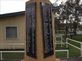 view gallery view galleryE48.4 km |  Willawarrin WW2 'obelisk', NSW, Australia Willawarrin WW2 'obelisk', NSW, Australia
in World War II Memorials / Monuments This short concrete column has been painted a 'cream colour', and has two long (tall) black granite plaques attached, for those that served in World War Two from the Willawarrin district, NSW. posted by: Grahame Cookie location: New South Wales, Australia date approved: 04/02/2017 last visited: never |
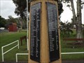 view gallery view galleryE48.4 km |  Willawarrin, NSW, Australia Willawarrin, NSW, Australia
in World War I Memorials and Monuments This concrete column has been painted a 'cream colour', and has two long (tall) black granite plaques attached, for those that served in World War One from the Willawarrin district, NSW. posted by: Grahame Cookie location: New South Wales, Australia date approved: 03/04/2017 last visited: never |
|