 view gallery view gallery SW17.1 km SW17.1 km
|   Troll Wall: The Untold Story of the British First Ascent of Europe's Tallest Rock Face - Åndalsnes, Norway Troll Wall: The Untold Story of the British First Ascent of Europe's Tallest Rock Face - Åndalsnes, Norway
in There's a Book About It A gripping story of one of the most dramatic first ascents in British climbing history. posted by:  Walking Boots Walking Boots location: Møre og Romsdal, Norway date approved: 11/07/2021 last visited: 06/29/2023 |
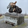
 view gallery view gallerySW17.1 km |  Troll -Troll Wall - Åndalsnes, Norway Troll -Troll Wall - Åndalsnes, Norway
in Epic Beings and Creatures In the rest area by The Troll Wall there is a large troll posted by: Walking Boots location: Møre og Romsdal, Norway date approved: 11/08/2021 last visited: 06/29/2023 |
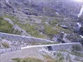
 view gallery view gallerySW17.1 km |  Troll Wall - Åndalsnes, Norway Troll Wall - Åndalsnes, Norway
in Established Rock Climbing Areas The Troll wall (Troldveggen) and the surrounding mountains in Romsdalen is a well-known area for climbing. posted by: Walking Boots location: Møre og Romsdal, Norway date approved: 08/13/2021 last visited: 06/29/2023 |
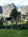 view gallery view gallerySW17.1 km |  Troll Wall - Åndalsnes, Norway Troll Wall - Åndalsnes, Norway
in Wikipedia Entries The Troll wall (Troldveggen) and the surrounding mountains in Romsdalen is a well-known area for climbing. posted by: Walking Boots location: Møre og Romsdal, Norway date approved: 09/29/2021 last visited: 06/29/2023 |
 view gallery view gallery W18.2 km W18.2 km
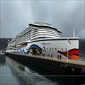
|  Cruise Terminal, Andalsnes, Norway Cruise Terminal, Andalsnes, Norway
in Cruise Ship Ports Andalsnes (Norway) Cruise Terminal posted by: Hatti75 location: Møre og Romsdal, Norway date approved: 05/17/2023 last visited: 06/27/2023 |
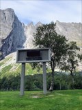
 view gallery view galleryW18.2 km |  Andalsnes Train Chapel, Andalsnes, Norway Andalsnes Train Chapel, Andalsnes, Norway
in Waychapels The Andalsnes Train Chapel is located directly at the port of the small town behind the Norwegian Mountaineering Centre. posted by: Hatti75 location: Møre og Romsdal, Norway date approved: 05/19/2023 last visited: 07/01/2023 |
 view gallery view galleryW20.6 km | Troll - Andalsnes, Norway in Epic Beings and Creatures This troll is standing with his motorbike on the access road to the Trollstigen. posted by: Hatti75 location: Møre og Romsdal, Norway date approved: 05/20/2023 last visited: 07/01/2023 |
 view gallery view gallerySW22.7 km |  Troll's Path (Trollstigen) - Åndalsnes - Norway Troll's Path (Trollstigen) - Åndalsnes - Norway
in National Scenic Byways The Troll's Path is a mountain road in Møre og Romsdal, Norway, part of Norwegian National Road 63 connecting Åndalsnes in Rauma and Valldal in Norddal. posted by:  Megrim1888 Megrim1888 location: Møre og Romsdal, Norway date approved: 02/06/2012 last visited: 06/29/2023 |
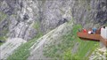 view gallery view gallerySW23.3 km |  Trollstigen - Overlook, Rauma Municipality, Møre og Romsdal, Norway Trollstigen - Overlook, Rauma Municipality, Møre og Romsdal, Norway
in Scenic Overlooks A breathtaking view from the platform. posted by: g300td location: Møre og Romsdal, Norway date approved: 10/21/2014 last visited: 06/29/2023 |
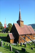 view gallery view galleryW29 km |  Rødven Stave Church, Møre og Romsdal, Norway Rødven Stave Church, Møre og Romsdal, Norway
in This Old Church Rødven Stave Church (Rødven stavkyrkje) is a stave church located in Rødven in the municipality of Rauma in Møre og Romsdal county, Norway. posted by: Megrim1888 location: Møre og Romsdal, Norway date approved: 02/05/2012 last visited: never |
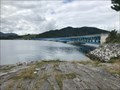 view gallery view gallery N47.6 km N47.6 km
|  Bergsøysundbrua - Øydegard, Norway Bergsøysundbrua - Øydegard, Norway
in Truss Bridges The Bergsøysund Bridge crosses the Bergsøysund and is part of Europavej E39. posted by: Walking Boots location: Møre og Romsdal, Norway date approved: 12/27/2021 last visited: never |
 view gallery view gallery NW49.1 km NW49.1 km
|  Jazzgutten - Molde, Norway Jazzgutten - Molde, Norway
in Musical Instruments Jazzgutten (The jazz boy) with his saxophone stands in the square with the fjord and the mountains as a background. posted by: Walking Boots location: Møre og Romsdal, Norway date approved: 01/15/2024 last visited: never |
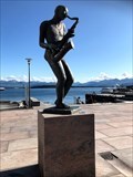 view gallery view galleryNW49.1 km |  250th Anniversary of Molde - Molde, Norway 250th Anniversary of Molde - Molde, Norway
in Community Commemoration Jazzgutten was a public gift for the city of Molde's 250th anniversary in 1992. posted by: Walking Boots location: Møre og Romsdal, Norway date approved: 01/10/2024 last visited: never |
 view gallery view galleryNW49.1 km |  Jazzgutten - Molde, Norway Jazzgutten - Molde, Norway
in Figurative Public Sculpture Jazzgutten (The jazz boy) with his saxophone stands in the square with the fjord and the mountains as a background. posted by: Walking Boots location: Møre og Romsdal, Norway date approved: 01/13/2024 last visited: never |
 view gallery view galleryNW49.1 km | ") City of Roses - Molde, Norway City of Roses - Molde, Norway
in Waymark Tours (WayTours) Molde is known for the many roses that grow in this particular climate. That is why Molde is also called "The City of Roses". posted by: Walking Boots location: Møre og Romsdal, Norway date approved: 01/19/2024 last visited: never |
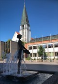
 view gallery view galleryNW49.2 km |  Rosepiken Rosepiken
in Fountains Fountain around a girl with a basket of roses at the place in front of the city hall. posted by: bjorges location: Møre og Romsdal, Norway date approved: 08/28/2006 last visited: 12/28/2021 |
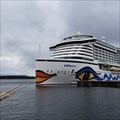 view gallery view galleryNW49.2 km | Cruise Terminal, Molde, Norway in Cruise Ship Ports Molde (Norway) Cruise Terminal posted by: Hatti75 location: Møre og Romsdal, Norway date approved: 05/18/2023 last visited: 06/27/2023 |
 view gallery view galleryNW49.2 km |  Molde rådhus, Norway Molde rådhus, Norway
in City and Town Halls The city hall of Molde posted by: bjorges location: Møre og Romsdal, Norway date approved: 08/28/2006 last visited: 12/28/2021 |
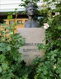 view gallery view galleryNW49.2 km |  LITERATURE: Bjørnstjerne Bjørnson 1903 - Molde, Norway LITERATURE: Bjørnstjerne Bjørnson 1903 - Molde, Norway
in Nobel Laureates In front of Alexandra Hotell is a bust of Bjørnstjerne Bjørnson who arwarded the Nobel Prize in Literature 1903. posted by: Walking Boots location: Møre og Romsdal, Norway date approved: 09/04/2021 last visited: never |
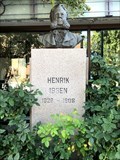 view gallery view galleryNW49.2 km |  Henrik Ibsen - Molde, Norway Henrik Ibsen - Molde, Norway
in Dead Poets' Society Memorials A granite column with a bust of the Norwegian poet and dramatist Henrik Ibsen in front of Alexandra Hotell posted by: Walking Boots location: Møre og Romsdal, Norway date approved: 09/07/2021 last visited: never |
 view gallery view galleryN54.2 km |  Kanestraum Ferjekai - Kanestraum, Norway Kanestraum Ferjekai - Kanestraum, Norway
in Ferries and Ferry Landings The three ferries, MF Moldefjord, MF Romsdalsfjord and MF Korsfjord sail between Kanestraum and Halsa. posted by: Walking Boots location: Møre og Romsdal, Norway date approved: 12/28/2021 last visited: never |
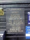 view gallery view galleryW60.2 km |  Lake Hornindalsvatnet, Norway Lake Hornindalsvatnet, Norway
in Natural Lakes Hornindalsvanet is Europe's deepest lake, offically measured to a depth of 514 meters (1665 feet). Its surface is 53 meters (256 feet ) above sea level and the bottom is about 461 meters (1494 feet ) below sea level. posted by: 2Hanweb location: Møre og Romsdal, Norway date approved: 08/14/2015 last visited: never |
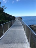 view gallery view galleryNW61 km |  Udsiktsstien - Atlantic Road - Averøy, Norway Udsiktsstien - Atlantic Road - Averøy, Norway
in Coastal Boardwalks Udsiktsstien is a Coastal Boardwalk around the rocky island Lyngholmen by the Atlantic Road posted by: Walking Boots location: Møre og Romsdal, Norway date approved: 01/05/2022 last visited: 08/16/2023 |
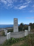 view gallery view galleryNW61.2 km |  Omkomne på havet - Averøy, Norway Omkomne på havet - Averøy, Norway
in Maritime Monuments and Memorials Granite monument at the Atlantic Road commemorating those who died at sea posted by: Walking Boots location: Møre og Romsdal, Norway date approved: 01/15/2022 last visited: never |
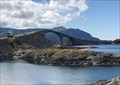 view gallery view galleryNW61.2 km |  Storseisundbrua - Averøy, Norway Storseisundbrua - Averøy, Norway
in Arch Bridges The Storseisundet Bridge is the longest of the eight bridges that make up the The Atlantic Road. posted by: Walking Boots location: Møre og Romsdal, Norway date approved: 11/09/2021 last visited: never |
|