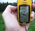
 view gallery view gallery S0.3 km S0.3 km
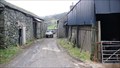
|   1848 - Low Newton Farm, Cumbria 1848 - Low Newton Farm, Cumbria
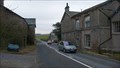
in Dated Buildings and Cornerstones The main A590 trunk road ran through the farmyard of Low Newton farm until the bypass opened in 2008. Now the road is much quieter but still splits the farm apart. posted by:  flipflopnick flipflopnick location: North West England, United Kingdom date approved: 02/02/2009 last visited: never |
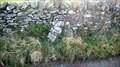
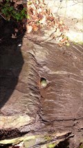
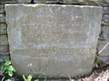
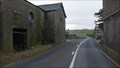 view gallery view galleryS0.3 km |  Low Newton Farm Cut Mark, Cumbria Low Newton Farm Cut Mark, Cumbria
in U.K. and Ireland Trigpoints A fading cut mark on the left side of large door surround of the farm buildings on the east side of the old A590 road. posted by: flipflopnick location: North West England, United Kingdom date approved: 02/01/2009 last visited: never |
 view gallery view gallery NE0.5 km NE0.5 km
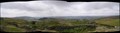
|  Newton Fell, South Cumbria Newton Fell, South Cumbria
in Scenic Overlooks Newton Fell is a high point on a ridge running alongside the main road, A590, across the south of county. Prominent above High Newton village. posted by: flipflopnick location: North West England, United Kingdom date approved: 08/06/2006 last visited: 02/18/2008 |
 view gallery view gallery NW0.6 km NW0.6 km
| High Newton Village Hall flush bracket, G2824, Cumbria in U.K. and Ireland Trigpoints High Newton village hall was the former school. The flush bracket is in full view. Hall now used for meetings and functions. posted by: flipflopnick location: North West England, United Kingdom date approved: 12/22/2008 last visited: never |
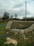
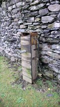 view gallery view galleryNW0.6 km |  High Newton Hand Pump, Cumbria High Newton Hand Pump, Cumbria
in Hand Operated Water Pumps This pump is boxed against the wall in the village of High Newton. The turnpike came through here in 1820, only being bypassed in 2007. posted by: flipflopnick location: North West England, United Kingdom date approved: 10/24/2010 last visited: never |
 view gallery view gallery SE1 km SE1 km
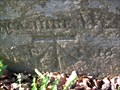
| Moss End Farm Flush Bracket G2823, Low Newton, Cumbria in U.K. and Ireland Trigpoints This flush bracket is low down on the facing wall of the main farmhouse, as you walk down into the farmyard. The walls have been rendered leaving this plate exposed, fortunately. posted by: flipflopnick location: North West England, United Kingdom date approved: 02/01/2009 last visited: never |
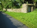
 view gallery view galleryS1.3 km |  Boundary Stone Cartmel Lane, Broughton East, Cumbria Boundary Stone Cartmel Lane, Broughton East, Cumbria
in Public Land Survey Marks This parish boundary stone is on the south side of the junction of Cartmel Lane, Old Town Hill and Hollow Lane, tucked up against the wall. posted by: flipflopnick location: North West England, United Kingdom date approved: 11/20/2010 last visited: never |
 view gallery view gallery SW1.9 km SW1.9 km
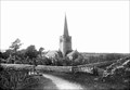
|  Field Broughton church Cumbria Field Broughton church Cumbria
in Photos Then and Now Field Broughton church Cumbria. Looking North West from the brow of adjacent road. posted by: flipflopnick location: North West England, United Kingdom date approved: 05/23/2006 last visited: 01/26/2008 |
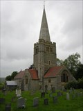 view gallery view gallerySW1.9 km |  St Peter's, Field Broughton, Cumbria - England St Peter's, Field Broughton, Cumbria - England
in Country Churches St Peter's is a sandstone building, not a native material, marked by its spire, which makes it stand out for miles around, in the flat valley bottom. posted by: flipflopnick location: North West England, United Kingdom date approved: 07/06/2006 last visited: 02/23/2008 |
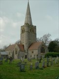 view gallery view gallerySW1.9 km | St. Peter's church-Field Broughton,Cumbria. in This Old Church St. Peter's church was built in 1894 and replaced an earlier Chapel of Ease which was built in 1745. posted by:  fellsmanhiker fellsmanhiker location: United Kingdom date approved: 09/30/2008 last visited: 10/08/2008 |
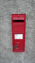 view gallery view gallerySW1.9 km |  Field Broughton VR postbox, Cumbria Field Broughton VR postbox, Cumbria
in Victorian Post Boxes This recently repainted Victorian postbox is in the wall of Field Broughton Parish Rooms. posted by: flipflopnick location: North West England, United Kingdom date approved: 05/12/2010 last visited: never |
 view gallery view galleryNW2.1 km | Saskills Rivet, Cumbria in U.K. and Ireland Trigpoints Saskills is an area of open access land on the ridge running above the A590, between Chapel House Plantation and Lindale. Rivet is in an outcrop of rock. Several to choose from. Superb views for very little effort. posted by: flipflopnick location: North West England, United Kingdom date approved: 01/07/2009 last visited: never |
 view gallery view galleryNW2.1 km | Ayside Bolt, Cumbria in U.K. and Ireland Trigpoints An OSBM bolt set in to a large prominent rock slab beside the old A590. posted by: flipflopnick location: North West England, United Kingdom date approved: 12/25/2008 last visited: never |
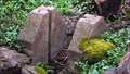
 view gallery view gallerySW2.1 km |  Field Broughton pinfold Field Broughton pinfold
in Made for the Millennium A nicely restored pinfold at Field Broughton Cumbria with the added addition of a seat to commemorate the millennium. posted by: fellsmanhiker location: United Kingdom date approved: 02/05/2008 last visited: 03/12/2008 |
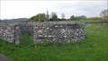 view gallery view gallerySW2.1 km |  Field Broughton Pinfold, Cumbria Field Broughton Pinfold, Cumbria
in Town and Village Pounds Field Broughton pinfold has been restored as a Millennium project, with nearby smaller pound turned in to a south facing seat. posted by: flipflopnick location: North West England, United Kingdom date approved: 05/12/2010 last visited: never |
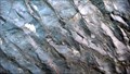 view gallery view gallerySE2.1 km |  Ripple Rocks, Lindale, Cumbria Ripple Rocks, Lindale, Cumbria
in Places of Geologic Significance The Ripple Rocks are beside the road through Lindale, on the north side of the road, facing east, at the entrance of a short uphill track. posted by: flipflopnick location: North West England, United Kingdom date approved: 01/14/2011 last visited: never |
 view gallery view gallerySE2.1 km |  Lindale Cumbria Palindrome - Lindale, UK Lindale Cumbria Palindrome - Lindale, UK
in Coordinate Palindromes Near Lindale village, in a field, on a public footpath, under the power lines. With or without the double zero in front of westing, its still a palindrome. posted by: flipflopnick location: North West England, United Kingdom date approved: 08/31/2006 last visited: never |
 view gallery view galleryNE2.1 km |  Lancashire and Westmorland County Boundary at Bleacrag Bridge, Cumbria Lancashire and Westmorland County Boundary at Bleacrag Bridge, Cumbria
in Border Crossings The river Winster used to be the old county boundary between Lancashire and Westmorland. Here the boundary is marked on a very fine inscribed stone laid into the Bleacrag bridge. posted by: flipflopnick location: North West England, United Kingdom date approved: 04/04/2008 last visited: never |
 view gallery view galleryNE2.1 km | Bleacrag Bridge Cut Mark, Cumbria in U.K. and Ireland Trigpoints Bleacrag bridge is on the old county boundary between Lancashire and Westmorland. The OS look to have over written the old inscription with their chiselling. posted by: flipflopnick location: North West England, United Kingdom date approved: 04/03/2008 last visited: never |
 view gallery view galleryS2.3 km |  Appledene Christmas Lights, Lindale, Cumbria Appledene Christmas Lights, Lindale, Cumbria
in Holiday Displays Every year Appledene puts on this display of Christmas Lights on Windermere Road in Lindale, Cumbria. There is music. Drive by viewing. posted by: flipflopnick location: North West England, United Kingdom date approved: 12/24/2006 last visited: never |
 view gallery view gallerySE2.3 km |  The Mill pond sluice - Lindale The Mill pond sluice - Lindale
in Historic Hand Operated Sluice Gates There used to be a mill in Lindale, fed by a mill pond. Both now gone. This sluice and a brick pillar remain. Water from the beck was fed into the pond via this sluice. posted by: flipflopnick location: North West England, United Kingdom date approved: 04/05/2016 last visited: never |
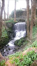 view gallery view gallerySE2.3 km |  The Weir - Lindale The Weir - Lindale
in Man-made Waterfalls The Weir is the local name for the obstruction in Lindale Beck to feed the mill pond, now gone. posted by: flipflopnick location: North West England, United Kingdom date approved: 04/05/2016 last visited: never |
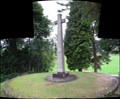 view gallery view gallerySE2.3 km |  Lindale World War Memorial Cumbria Lindale World War Memorial Cumbria
in World War I Memorials and Monuments Lindale's memorial is near the new (2006) bowling green next to church yard. Visible from road B5271 through top of Lindale village. On a mound, set in own fenced area, which is a well maintained. Views East are very good. posted by: flipflopnick location: North West England, United Kingdom date approved: 08/18/2006 last visited: 02/17/2008 |
 view gallery view gallery N2.3 km N2.3 km
|  Height Quaker Burial Ground, Cartmel Fell, Cumbria Height Quaker Burial Ground, Cartmel Fell, Cumbria
in Worldwide Cemeteries The Quaker burial ground is a short distance up the road from Height Meeting House, on the other side of the road. Sheltered by trees and a high wall. Entrance through stone covered lych type gate way. A scenic small graveyard. Still maintained. posted by: flipflopnick location: North West England, United Kingdom date approved: 07/05/2007 last visited: never |
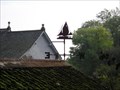 view gallery view galleryS2.3 km |  Two Masted Yacht Vane, Hampsfell, Cumbria Two Masted Yacht Vane, Hampsfell, Cumbria
in Unique Weathervanes A rusty vane of a two masted yacht on a garage next to a public footpath on the way up to Hampsfell. posted by: flipflopnick location: North West England, United Kingdom date approved: 10/17/2006 last visited: 10/17/2006 |
|