 view gallery view gallery SE13.5 km SE13.5 km
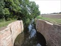
|   Former Ticklepenny's Lock On Louth Navigation - Keddington, UK Former Ticklepenny's Lock On Louth Navigation - Keddington, UK
in Waterway Locks, Planes and Lifts This lock was the third lock on the Louth Navigation. posted by:  dtrebilc dtrebilc location: Eastern England, United Kingdom date approved: 09/24/2021 last visited: never |
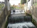
 view gallery view gallerySE13.7 km | Former Keddington Church Lock On Louth Navigation - Keddington, UK in Waterway Locks, Planes and Lifts This lock was the second lock on the Louth Navigation posted by: dtrebilc location: Eastern England, United Kingdom date approved: 09/24/2021 last visited: never |
 view gallery view gallerySE13.7 km | Former Town Lock On The Louth Navigation - Louth, UK in Waterway Locks, Planes and Lifts This lock was the first lock on the Louth Navigation in the town of Louth. posted by: dtrebilc location: Yorkshire, United Kingdom date approved: 09/24/2021 last visited: never |
 view gallery view gallery S14 km S14 km
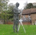
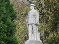
|  Searching - Louth, UK Searching - Louth, UK
in Figurative Public Sculpture This sculpture is one of three similar statues in Louth erected to mark the Greenwich Meridian that passes through the town of Louth. posted by: dtrebilc location: Eastern England, United Kingdom date approved: 02/07/2019 last visited: never |
 view gallery view galleryS14 km |  Louth Public Library - Louth, UK Louth Public Library - Louth, UK
in Libraries This library is run by Lincolnshire County council. posted by: dtrebilc location: Eastern England, United Kingdom date approved: 02/10/2019 last visited: never |
 view gallery view galleryS14 km | Mapping - Louth, UK in Figurative Public Sculpture This sculpture is one of three similar statues in Louth erected to mark the Greenwich Meridian that passes through the town of Louth. posted by: dtrebilc location: Eastern England, United Kingdom date approved: 02/07/2019 last visited: never |
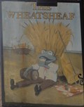 view gallery view galleryS14 km |  The Wheatsheaf, 62 Westgate - Louth, UK The Wheatsheaf, 62 Westgate - Louth, UK
in Pictorial Pub Signs The wheatsheaf is a common pub name especially in arable farming areas. posted by: dtrebilc location: Eastern England, United Kingdom date approved: 02/07/2019 last visited: never |
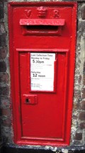 view gallery view galleryS14 km |  Wall mounted Box Eastgate Louth Linc's Wall mounted Box Eastgate Louth Linc's
in Victorian Post Boxes Wall mounted V.R Box in town use. posted by: ebbandflo location: East Midlands, United Kingdom date approved: 08/08/2009 last visited: 10/20/2016 |
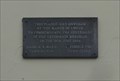 view gallery view galleryS14 km |  Greenwich Meridian - 100 Years - Louth, UK Greenwich Meridian - 100 Years - Louth, UK
in Commercial Commemorations This modest plaque celebrates the centenary of the recommendation of the Greenwich Meridian as the international standard for zero degrees longitude. posted by: dtrebilc location: Eastern England, United Kingdom date approved: 02/09/2019 last visited: never |
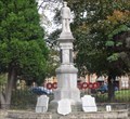 view gallery view galleryS14 km |  Louth War Memorial - Louth, UK Louth War Memorial - Louth, UK
in World War I Memorials and Monuments This war memorial was erected in 1921 to commemorate the men or Louth who fell during the First World War. posted by: dtrebilc location: Eastern England, United Kingdom date approved: 02/15/2019 last visited: never |
 view gallery view galleryS14 km | Louth War Memorial Soldier - Louth, UK in Figurative Public Sculpture This sculpture of a WWI soldier stands on a war memorial erected in 1921 to commemorate the men or Louth who fell during the First World War. posted by: dtrebilc location: Eastern England, United Kingdom date approved: 02/07/2019 last visited: never |
 view gallery view gallery NE15 km NE15 km
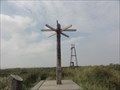
|  Direction Arrows - Spurn Point, UK Direction Arrows - Spurn Point, UK
in Direction and Distance Arrows The direction arrows are at Spurn Point posted by: dtrebilc location: Yorkshire, United Kingdom date approved: 09/21/2021 last visited: never |
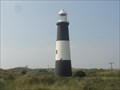 view gallery view galleryNE15.9 km |  Spurn Lighthouse - Spurn Head, UK Spurn Lighthouse - Spurn Head, UK
in Coastal Lighthouses This lighthouse was built in 1895 and replaced two earlier ones. posted by: dtrebilc location: Yorkshire, United Kingdom date approved: 09/21/2021 last visited: never |
 view gallery view galleryNE16.1 km |  Port War Signal Station - Spurn , UK Port War Signal Station - Spurn , UK
in World War I Sites This small fortiefied military base controlled the shipping lanes off the Humber Estuary at the entrance to the North Sea. posted by: dtrebilc location: Yorkshire, United Kingdom date approved: 11/17/2021 last visited: never |
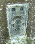 view gallery view gallery W16.7 km W16.7 km
|  Flush Bracket , Acre UK Flush Bracket , Acre UK
in U.K. and Ireland Trigpoints This flush bracket is located near Acre, UK. posted by: InGodsHands location: North East England, United Kingdom date approved: 10/01/2012 last visited: 09/01/2010 |
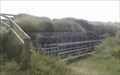
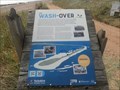 view gallery view galleryNE19.5 km |  The Wash-Over - Spurn Head, UK The Wash-Over - Spurn Head, UK
in UK Historical Markers Spurn Head is a narrow spit of land with the Humber estuary on one side and the North Sea on the over that is susceptible to storm damage. posted by: dtrebilc location: Yorkshire, United Kingdom date approved: 09/23/2021 last visited: never |
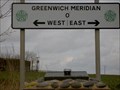 view gallery view gallery N21.7 km N21.7 km
|  Patrington, Humberside Meridian Marker Patrington, Humberside Meridian Marker
in Greenwich Meridian Markers On The B1445 to the east of Patrington, Humberside on the road to Spurn Head. posted by: splowe location: Yorkshire, United Kingdom date approved: 02/17/2007 last visited: 12/29/2015 |
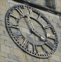 view gallery view galleryN22 km |  St Patrick's Church Clock - Patrington, UK St Patrick's Church Clock - Patrington, UK
in Town Clocks The square tower on this church has a clock face on three sides of the tower. posted by: dtrebilc location: Yorkshire, United Kingdom date approved: 11/19/2021 last visited: never |
 view gallery view gallery SW27.4 km SW27.4 km
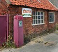
|  Sad old pump in rural Lincolnshire UK Sad old pump in rural Lincolnshire UK
in Vintage Gasoline Pumps A sad old pump outside a village petrol station in Rural Lincolnshire posted by: V70PDB location: East Midlands, United Kingdom date approved: 08/21/2007 last visited: never |
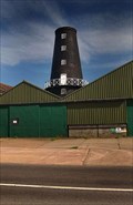 view gallery view gallerySW27.5 km |  Wragby Mill Wragby Mill
in Windmills Wragby Mill posted by: V70PDB location: United Kingdom date approved: 05/11/2007 last visited: never |
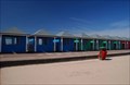 view gallery view gallerySE27.5 km |  Mablethorpe in Lincolnshire UK Mablethorpe in Lincolnshire UK
in Beach Huts Beach huts in Mablethorpe posted by: V70PDB location: East Midlands, United Kingdom date approved: 04/14/2007 last visited: 03/09/2008 |
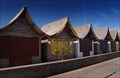 view gallery view gallerySE28 km | Beach Huts at Trusthorpe Lincolnshire UK in Beach Huts Beach Huts at Trusthorpe in Lincolnshire posted by: V70PDB location: East Midlands, United Kingdom date approved: 05/11/2007 last visited: 10/22/2011 |
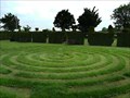 view gallery view gallerySW28.2 km |  Turf labyrinth at Wragby, Lincolnshire. Turf labyrinth at Wragby, Lincolnshire.
in Labyrinths A turf labyrinth at a garden centre in Lincolnshire UK posted by: V70PDB location: East Midlands, United Kingdom date approved: 06/10/2007 last visited: never |
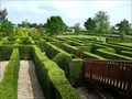 view gallery view gallerySW28.2 km | Maze at Wragby in Lincolnshire UK in Outdoor Mazes A Maze at a garden centre in Wragby Lincolnshire UK posted by: V70PDB location: United Kingdom date approved: 06/10/2007 last visited: never |
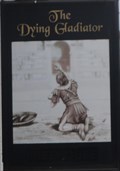 view gallery view galleryW29 km | The Dying Gladiator - Brigg, UK in Pictorial Pub Signs This pub sign shows a Roman gladiator dying in an arena with his shield next to him. posted by: dtrebilc location: Yorkshire, United Kingdom date approved: 09/08/2021 last visited: never |
|