 view gallery view gallery N1 km N1 km
|   Walberswick, Suffolk Walberswick, Suffolk
in Pictorial Village Signs Walberswick village sign - stolen in the 1980s amidst mysterious circumstances, but uncovered and returned some 30 years later. posted by:  SMacB SMacB location: Eastern England, United Kingdom date approved: 06/09/2014 last visited: 08/05/2015 |
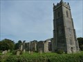 view gallery view galleryN1 km |  St Andrew - Walberswick, Suffolk St Andrew - Walberswick, Suffolk
in Medieval Churches St Andrew's Church, Walberswick is a Grade I listed parish church in the Church of England in Walberswick. posted by: SMacB location: Eastern England, United Kingdom date approved: 06/08/2014 last visited: 08/05/2015 |
 view gallery view galleryN1 km |  St Andrew's Church - Walberswick, Suffolk, England St Andrew's Church - Walberswick, Suffolk, England
in Wikipedia Entries St Andrew's Church, Walberswick is a Grade I listed parish church in the Church of England in Walberswick. posted by: SMacB location: Eastern England, United Kingdom date approved: 06/10/2014 last visited: 08/05/2015 |
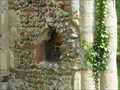
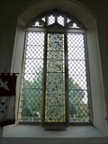 view gallery view galleryN1 km |  Stained Glass Windows, St Andrew's Church - Walberswick, Suffolk Stained Glass Windows, St Andrew's Church - Walberswick, Suffolk
in Stained Glass Windows When the surrounding ruins of the church were excavated in 1930 a quantity of 14th and 15th century stained glass, all in fragments, was found and many of these fragments were assembled into one light of a window on the south wall posted by: SMacB location: Eastern England, United Kingdom date approved: 06/11/2014 last visited: 08/05/2015 |
 view gallery view galleryN1 km |  Cut benchmark and bolt, St Andrew - Walberswick, Suffolk Cut benchmark and bolt, St Andrew - Walberswick, Suffolk
in European Historic Survey Stones, Monuments and Benchmarks Cut benchmark and bolt on south west angle of church tower, south east face of buttress. posted by: SMacB location: Eastern England, United Kingdom date approved: 06/10/2014 last visited: 08/05/2015 |
 view gallery view galleryN1 km |  Cut benchmark and bolt, St Andrew - Walberswick, Suffolk Cut benchmark and bolt, St Andrew - Walberswick, Suffolk
in U.K. and Ireland Trigpoints Cut benchmark and bolt on south west angle of church tower, south east face of buttress. posted by: SMacB location: Eastern England, United Kingdom date approved: 06/09/2014 last visited: 08/05/2015 |
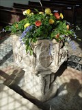 view gallery view galleryN1 km |  Baptism Font, St Andrew's Church - Walberswick, Suffolk Baptism Font, St Andrew's Church - Walberswick, Suffolk
in Stone Church Artefacts A grand font, surviving from the original 15th century building. posted by: SMacB location: Eastern England, United Kingdom date approved: 06/12/2014 last visited: 08/05/2015 |
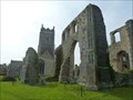
 view gallery view galleryN1 km | Piscinas, St Andrew's Church - Walberswick, Suffolk in Stone Church Artefacts 3 piscinas in the ruins of the old 15th century St Andrew's church, Walberswick posted by: SMacB location: Eastern England, United Kingdom date approved: 06/12/2014 last visited: 08/05/2015 |
 view gallery view gallery NE1.8 km NE1.8 km
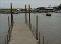
|  Southwold to Walberswick Ferry - Ferry Road, Southwold, Suffolk, UK. Southwold to Walberswick Ferry - Ferry Road, Southwold, Suffolk, UK.
in Ferries and Ferry Landings This must be one of the world's shorter ferry crossings. posted by:  HitchinLookers HitchinLookers location: Eastern England, United Kingdom date approved: 06/28/2011 last visited: 08/05/2015 |
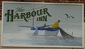 view gallery view galleryNE2.1 km |  Harbour Inn - Black Shore, Southwold, Suffolk, UK. Harbour Inn - Black Shore, Southwold, Suffolk, UK.
in Pictorial Pub Signs What else could a pub located here possibly have been called? posted by: HitchinLookers location: Eastern England, United Kingdom date approved: 06/28/2011 last visited: 09/21/2018 |
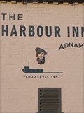 view gallery view galleryNE2.1 km |  Flood level - The Harbour Inn, Blackshore Quay, Southwold, Suffolk. IP18 6TA. Flood level - The Harbour Inn, Blackshore Quay, Southwold, Suffolk. IP18 6TA.
in High Level Marks Recording the infamous flood of 1953 which did massive damage all along the North Sea coastline. In England 307 people were killed in the counties of Lincolnshire, Norfolk, Suffolk and Essex. posted by: greysman location: Eastern England, United Kingdom date approved: 09/30/2018 last visited: 10/18/2018 |
 view gallery view galleryN2.3 km | Blackshore Mill, Reydon - Walberswick, Suffolk, England in Wikipedia Entries Blackshore Mill is a Grade II listed tower mill at Reydon, Suffolk, England which has been conserved. posted by: SMacB location: Eastern England, United Kingdom date approved: 06/19/2014 last visited: 08/05/2015 |
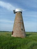 view gallery view galleryN2.3 km |  Blackshore Mill, Reydon - Walberswick, Suffolk Blackshore Mill, Reydon - Walberswick, Suffolk
in Windmills Blackshore Mill is a Grade II listed tower mill at Reydon, Suffolk, England which has been conserved. posted by: SMacB location: Eastern England, United Kingdom date approved: 06/17/2014 last visited: 08/05/2015 |
 view gallery view galleryNE2.9 km |  "The Casino", Gun Hill - Southwold, Suffolk "The Casino", Gun Hill - Southwold, Suffolk
in Octagon Buildings Octagonal building on Gun Hill, Southwold, known locally as the Casino. posted by: SMacB location: Eastern England, United Kingdom date approved: 06/15/2014 last visited: 09/22/2018 |
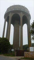 view gallery view galleryNE2.9 km |  Water Tower - Southwold, Suffolk, UK. Water Tower - Southwold, Suffolk, UK.
in Water Towers This water tower is one of a pair standing side by side here. This one is the current supplier of water to the town of Southwold and the small communities in the immediate vicinity. posted by: HitchinLookers location: Eastern England, United Kingdom date approved: 06/28/2011 last visited: 09/22/2018 |
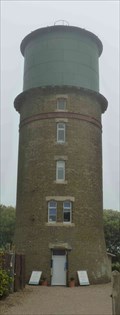 view gallery view galleryNE2.9 km | Water Tower (disused) - Southwold, Suffolk, UK. in Water Towers This one of a pair of water towers is now no longer used for it's original purpose, but has an interesting history. posted by: HitchinLookers location: Eastern England, United Kingdom date approved: 06/28/2011 last visited: 06/23/2022 |
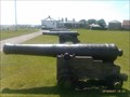 view gallery view galleryNE2.9 km |  Cannons - Gun Hill, Southwold, Suffolk, England Cannons - Gun Hill, Southwold, Suffolk, England
in Static Artillery Displays On Gun Hill, overlooking the sea a collection of 6 eighteen pound cannon. posted by: SMacB location: Eastern England, United Kingdom date approved: 06/21/2014 last visited: 09/22/2018 |
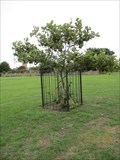 view gallery view galleryNE3.1 km |  The Queen Mother's Oak - The Common, Southwold, Suffolk. The Queen Mother's Oak - The Common, Southwold, Suffolk.
in Dedicated Trees An Oak tree, planted to commemorate the Queen Mum's 80th Birthday.
52°19.56366', 001°40.54774' posted by: greysman location: Eastern England, United Kingdom date approved: 10/02/2018 last visited: 10/18/2018 |
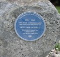 view gallery view galleryNE3.1 km |  William Godell, Nursemaid's Park, Southwold, Suffolk. William Godell, Nursemaid's Park, Southwold, Suffolk.
in Blue Plaques A large limestone boulder commemorates the gift of land to the town by a local entrepreneur. posted by: greysman location: United Kingdom date approved: 10/07/2018 last visited: 06/23/2022 |
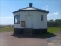
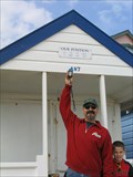
 view gallery view galleryNE3.1 km |  N 52° 19.442 E 001° 40.852, Southwold, Suffolk, England N 52° 19.442 E 001° 40.852, Southwold, Suffolk, England
in Permanent Geographic Coordinates "Our Position", a beach hut, in Southwold with name plaque that reads N 52 19 26.5, E 001 40 51.1 posted by: bluelamb03 location: Eastern England, United Kingdom date approved: 04/28/2011 last visited: 08/06/2015 |
 view gallery view galleryNE3.1 km |  Beach Huts, Southwold, Suffolk, England Beach Huts, Southwold, Suffolk, England
in Beach Huts This is the location of "Our Position", a beach hut, in Southwold with name plaque that reads N 52 19 26.5, E 001 40 51.1 posted by: bluelamb03 location: Eastern England, United Kingdom date approved: 08/09/2011 last visited: 08/06/2015 |
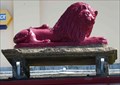 view gallery view galleryNE3.1 km | Red Lion - South Green, Southwold, Suffolk, UK. in Pictorial Pub Signs The Red Lion is the most common pub name in the UK. posted by: HitchinLookers location: Eastern England, United Kingdom date approved: 06/28/2011 last visited: 06/23/2022 |
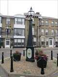 view gallery view galleryNE3.2 km |  Town Pump - Market Place, Southwold, Suffolk. Town Pump - Market Place, Southwold, Suffolk.
in Hand Operated Water Pumps A cast iron pump in an unusual triangular plan. posted by: greysman location: Eastern England, United Kingdom date approved: 11/03/2018 last visited: 06/23/2022 |
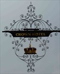 view gallery view galleryNE3.2 km | Crown - High Street, Southwold, Suffolk, UK. in Pictorial Pub Signs A crown is a common subject for a pub sign, since it was easy to paint and recognise. posted by: HitchinLookers location: Eastern England, United Kingdom date approved: 06/28/2011 last visited: 10/18/2018 |
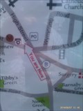 view gallery view galleryNE3.2 km |  High Street - Southwold, Suffolk High Street - Southwold, Suffolk
in 'You Are Here' Maps You are here sign at the junction of Victoria Street and High Street, Southwold, Suffolk. posted by: SMacB location: Eastern England, United Kingdom date approved: 06/09/2014 last visited: 09/22/2018 |
|