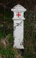
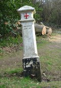
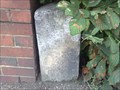
 view gallery view gallery W0.3 km W0.3 km
|   Coal Tax Post 160 - Chiptead, Surrey Coal Tax Post 160 - Chiptead, Surrey
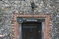
in London Coal Tax Posts This post is located near Chipstead rail station adjacent to a bridge. posted by:  halthornhill halthornhill location: South East England, United Kingdom date approved: 06/07/2011 last visited: never |
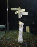 view gallery view gallery E0.6 km E0.6 km
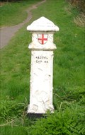
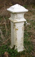
| Coal Tax Post 162, nr Chipstead, Surrey in London Coal Tax Posts A coal tax post at a 5-way road junction in Surrey posted by:  Team Sieni Team Sieni location: South East England, United Kingdom date approved: 11/29/2012 last visited: 05/27/2014 |
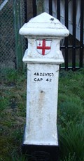 view gallery view gallery SE1.4 km SE1.4 km
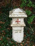
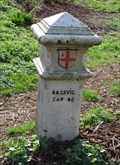
| Coal Post 164 - Netherne-on-the-Hill in London Coal Tax Posts Located on the A23 close to the entrance to a new housing development. posted by: Merstham Mafia location: South East England, United Kingdom date approved: 03/30/2009 last visited: 04/23/2011 |
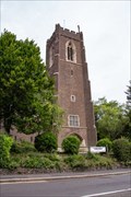
 view gallery view gallery NE2.7 km NE2.7 km
|  St Andrew's Church Tower - Woodmansterne Road, Coulsdon, UK St Andrew's Church Tower - Woodmansterne Road, Coulsdon, UK
in Bell Towers The tower of St Andrew's church, in Coulsdon, houses one bell that is rung before services and on other special occasions. posted by: Master Mariner location: South East England, United Kingdom date approved: 06/19/2019 last visited: never |
 view gallery view galleryNE2.7 km |  St Andrew's Church - Woodmansterne Road, Coulsdon, UK St Andrew's Church - Woodmansterne Road, Coulsdon, UK
in This Old Church St Andrew's church is an Anglian church located in an elevated position overlooking Coulsdon. The current building was constructed between 1911 and 1914 and continues to serve the local community. posted by: Master Mariner location: South East England, United Kingdom date approved: 06/20/2019 last visited: never |
 view gallery view galleryNE2.7 km |  St Andrew's Church - Woodmansterne Road, Coulsdon, UK St Andrew's Church - Woodmansterne Road, Coulsdon, UK
in Anglican and Episcopal Churches St Andrew's church is an Anglian church located in an elevated position overlooking Coulsdon. The current building was constructed between 1911 and 1914 and continues to serve the local community. posted by: Master Mariner location: South East England, United Kingdom date approved: 06/19/2019 last visited: never |
 view gallery view gallerySE2.7 km | Coal Post 166 - Coulsdon in London Coal Tax Posts Nice Coal Tax Post close to Happy Valley and Farthing Down. posted by: Merstham Mafia location: South East England, United Kingdom date approved: 04/05/2009 last visited: 04/23/2011 |
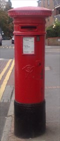
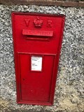 view gallery view galleryNE2.7 km |  Victorian Wall Post Box - Coulsdon, Surrey, UK Victorian Wall Post Box - Coulsdon, Surrey, UK
in Victorian Post Boxes A Victorian wall post box on the A327 in Coulsdon, Surrey, UK posted by: ntpayne location: Southern England, United Kingdom date approved: 01/18/2019 last visited: 06/18/2019 |
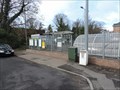
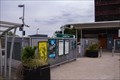 view gallery view galleryNE2.9 km |  Coulsdon Town Railway Station - Leaden Hill, Coulsdon, UK Coulsdon Town Railway Station - Leaden Hill, Coulsdon, UK
in Wikipedia Entries Coulsdon Town railway station serves trains operated by the Southern franchise. Originally, the station was called Smitham and opened in 1904 with the name change coming in 2011. The entrance and ticket office are to the south of the tracks. posted by: Master Mariner location: South East England, United Kingdom date approved: 06/19/2019 last visited: never |
 view gallery view galleryNE2.9 km |  Coulsdon Town Railway Station - Leaden Hill, Coulsdon, UK Coulsdon Town Railway Station - Leaden Hill, Coulsdon, UK
in Train Stations/Depots Coulsdon Town railway station serves trains operated by the Southern franchise. Originally, the station was called Smitham and opened in 1904 with the name change coming in 2011. The entrance and ticket office are to the south of the tracks. posted by: Master Mariner location: South East England, United Kingdom date approved: 06/21/2019 last visited: never |
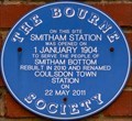 view gallery view galleryNE2.9 km |  Smitham (Coulsdon Town) Railway Station - Leaden Hill, Coulsdon, UK Smitham (Coulsdon Town) Railway Station - Leaden Hill, Coulsdon, UK
in UK Historical Markers Originally, the station was called Smitham when opened in 1904 with the name being changed to Coulsdon Town in 2011. A plaque, close to the station's entrance,gives a brief history. posted by: Master Mariner location: South East England, United Kingdom date approved: 06/30/2019 last visited: never |
 view gallery view gallery SW3.4 km SW3.4 km
|  Parsons Cottage, Chipstead, Surrey UK Parsons Cottage, Chipstead, Surrey UK
in Pre-Victorian Historic Homes Surrey County Council Building of Historic Interest 188
Parsons Cottage, Chipstead, Surrey. posted by: halthornhill location: South East England, United Kingdom date approved: 07/03/2011 last visited: never |
 view gallery view gallerySW4.3 km | Coal Post 155 - Kingswood in London Coal Tax Posts Located on the A23 at a bus stop in Kingswood. posted by: Merstham Mafia location: South East England, United Kingdom date approved: 03/30/2009 last visited: 02/06/2019 |
 view gallery view galleryE4.3 km | Coal Post 167 - Coulsdon in London Coal Tax Posts Nice Coal Tax post close to the road in Coulsdon. posted by: Merstham Mafia location: South East England, United Kingdom date approved: 04/05/2009 last visited: 04/23/2011 |
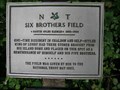 view gallery view gallerySE4.5 km |  Six Brothers Field, Chaldon, Surrey Six Brothers Field, Chaldon, Surrey
in National Trust U.K. Six Brothers Field is Chaldon's main recreational area. It was donated by Martin Coles Harman in memory of himself and his brothers. posted by: Team Sieni location: South East England, United Kingdom date approved: 08/19/2007 last visited: never |
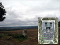 view gallery view gallerySE4.7 km |  Ockley Hill Trigpoint Ockley Hill Trigpoint
in U.K. and Ireland Trigpoints Trig Point on North Downs Way, near to village of Chaldon, Surrey. posted by: Team Sieni location: United Kingdom date approved: 08/19/2007 last visited: 07/21/2013 |
 view gallery view gallerySW4.7 km | Coal Post 154 - Banstead Heath in London Coal Tax Posts Located close to one of the entrances to Banstead Heath, this Coal Tax Post is all painted in white and needs some attention. posted by: Merstham Mafia location: South East England, United Kingdom date approved: 03/30/2009 last visited: 02/06/2019 |
 view gallery view galleryE4.7 km | Coal Post 168 - Coulsdon in London Coal Tax Posts Another nice Coal Tax post. posted by: Merstham Mafia location: South East England, United Kingdom date approved: 04/05/2009 last visited: 04/23/2011 |
 view gallery view gallery NW4.8 km NW4.8 km
|  Belmont Boundary Marker, B2230, Belmont, Surrey, UK Belmont Boundary Marker, B2230, Belmont, Surrey, UK
in Public Land Survey Marks A rather grubby looking boundary marker showing where Sutton & Cheam ended and Banstead began. posted by: AngelPick location: South East England, United Kingdom date approved: 08/12/2011 last visited: 03/23/2014 |
 view gallery view galleryNW4.8 km |  B2230 Milestone, Belmont, Surrey UK B2230 Milestone, Belmont, Surrey UK
in Milestones This little example is half buried and is hiding beside a dwarf brick wall with a tree behind it. Not easy to spot, keep your eyes peeled here. The co-ords are very good though. posted by: AngelPick location: South East England, United Kingdom date approved: 08/07/2011 last visited: 03/23/2014 |
 view gallery view galleryNW4.8 km | Belmont Station - Station Approach, Belmont, London, UK in Wikipedia Entries Belmont station has a single track passing through it. The station is located to the south of Sutton and north of Banstead Downs in Surrey. posted by: Master Mariner location: London, United Kingdom date approved: 08/25/2014 last visited: never |
 view gallery view galleryNW4.8 km | Belmont Station - Station Approach, Belmont, London, UK in Train Stations/Depots Belmont station has a single track passing through it. The station is located to the south of Sutton and north of Banstead Downs in Surrey. posted by: Master Mariner location: London, United Kingdom date approved: 08/25/2014 last visited: never |
 view gallery view galleryNW5 km | Victorian Postbox, Station Road, Belmont, Surrey UK in Victorian Post Boxes Post Box in pretty good nick on Station Road. SM2 35 posted by: AngelPick location: South East England, United Kingdom date approved: 09/30/2011 last visited: 03/23/2014 |
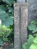
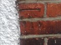
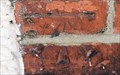 view gallery view galleryNW5 km |  Cut Bench Mark - King's Road, Belmont, Surrey, UK Cut Bench Mark - King's Road, Belmont, Surrey, UK
in European Historic Survey Stones, Monuments and Benchmarks This mark is cut into the brickwork of a building on the east side of King's Road at the junction with Station Road in Belmont. posted by: Master Mariner location: London, United Kingdom date approved: 03/26/2014 last visited: 04/09/2014 |
 view gallery view galleryNW5 km | CBM, Station Road/Kings Road, Belmont, Surrey UK in U.K. and Ireland Trigpoints Cut Benchmark on the corner of Station Road and Kings Road in Belmont. posted by: AngelPick location: South East England, United Kingdom date approved: 09/28/2011 last visited: 03/23/2014 |
|