 view gallery view gallery N4.7 km N4.7 km
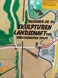
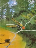
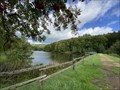
|   Eifel-Ardennen Radweg, Niederprum, Germany Eifel-Ardennen Radweg, Niederprum, Germany
in 'You Are Here' Maps Eifel-Ardennen Radweg/ Sculpturenpark, Niedeprum posted by:  TeamYakara TeamYakara location: Rheinland-Pfalz, Germany date approved: 09/29/2019 last visited: 03/12/2022 |
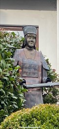 view gallery view galleryN5.8 km |  Bertrada von Mürlenbach - Prüm, RLP Bertrada von Mürlenbach - Prüm, RLP
in Statues of Historic Figures Bertrada von Mürlenbach posted by:  Tillba Tillba location: Rheinland-Pfalz, Germany date approved: 11/06/2021 last visited: never |
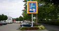 view gallery view galleryN5.8 km |  Aldi Süd - Prüm - Germany Aldi Süd - Prüm - Germany
in ALDI Stores One of the 1.886 Aldi Supermarkets of Aldi Süd in Germany is this one in Prüm. posted by: eilers1 location: Rheinland-Pfalz, Germany date approved: 04/04/2019 last visited: 04/04/2019 |
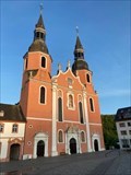 view gallery view galleryN5.8 km |  St. Salvator Basilika, Prüm, Rheinland-Pfalz, Deutschland St. Salvator Basilika, Prüm, Rheinland-Pfalz, Deutschland
in Roman Catholic Churches Basilika in Prüm posted by: Tillba location: Rheinland-Pfalz, Germany date approved: 11/05/2021 last visited: never |
 view gallery view gallery W6 km W6 km
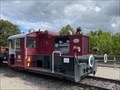
|  Eisenbahnmuseum Pronsfeld - Pronsfeld, RLP, Germany Eisenbahnmuseum Pronsfeld - Pronsfeld, RLP, Germany
in Railroad Museums Kleines Eisenbahn-Freilichtmuseum am ehemaligen Bahnhof in Pronsfeld -
Small open-air museum at the former train station in Pronsfeld posted by: Tillba location: Rheinland-Pfalz, Germany date approved: 09/17/2022 last visited: 06/18/2023 |
 view gallery view gallery SE6 km SE6 km
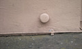
|  TP-Bolzen - Kirche St. Helena - Lasel - Rheinland-Pfalz - Germany TP-Bolzen - Kirche St. Helena - Lasel - Rheinland-Pfalz - Germany
in German Trigonometric Points TP-bolt fastened at St. Helena church in Lasel, a small village in Germany. posted by: eilers1 location: Rheinland-Pfalz, Germany date approved: 10/04/2018 last visited: 10/05/2018 |
 view gallery view galleryN6.6 km | Waldpfad Tettenbusch, Prüm, RLP, Germany in 'You Are Here' Maps Infotafel am Beginn des Waldpfads
Information board at the beginning of the forest trail posted by: Tillba location: Rheinland-Pfalz, Germany date approved: 09/26/2022 last visited: never |
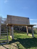 view gallery view galleryW7.1 km |  XXL-Bank, Pronsfeld, RLP, Germany XXL-Bank, Pronsfeld, RLP, Germany
in Artistic Seating XXL-Bank bei Pronsfeld
XXL-bench near Pronsfeld posted by: Tillba location: Rheinland-Pfalz, Germany date approved: 10/18/2022 last visited: never |
 view gallery view gallery SW7.4 km SW7.4 km
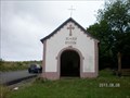
|  Stations of the Cross XI - XIV, Waxweiler - Germany Stations of the Cross XI - XIV, Waxweiler - Germany
in Outdoor Stations of the Cross Way of the Cross - 11th - 14th Station, placed in a small chapel next to the road.
Waxweiler, Pintesfelder Straße posted by: eilers1 location: Rheinland-Pfalz, Germany date approved: 03/29/2019 last visited: 03/29/2019 |
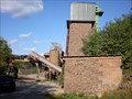 view gallery view gallerySW7.6 km |  Schotterwerk und Edelsplittanlage Waxweiler - Eifel - Germany Schotterwerk und Edelsplittanlage Waxweiler - Eifel - Germany
in Active Quarries One of the two quarries from the company Köppen-Bitburg in the Eifel area in Germany.
No entrance for visitors. posted by: eilers1 location: Rheinland-Pfalz, Germany date approved: 08/19/2013 last visited: 08/19/2013 |
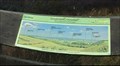 view gallery view galleryN7.6 km |  Eifel-Blick Gondenbrett Katzenkopf, Gondenbrett, RLP, Germany Eifel-Blick Gondenbrett Katzenkopf, Gondenbrett, RLP, Germany
in Orientation Tables Aussichtsplattform mit schönen Rund- und Weitblick
Viewing platform with beautiful panoramic and far-reaching views posted by: Tillba location: Rheinland-Pfalz, Germany date approved: 10/15/2022 last visited: never |
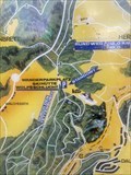 view gallery view galleryN8.4 km | Wanderparkplatz Nr. 15, Wolfsschlucht, Prüm, RLP, Germany in 'You Are Here' Maps Wanderkarte am Wanderparkplatz an der Wolfsschlucht
Hiking map at the hiking car park Wolfsschlucht posted by: Tillba location: Rheinland-Pfalz, Germany date approved: 11/03/2023 last visited: never |
 view gallery view galleryN8.9 km | St. Dionysius, Gondenbrett, RLP, Germany in Roman Catholic Churches Kirche in Gondenbrett
Church in Gondenbrett posted by: Tillba location: Rheinland-Pfalz, Germany date approved: 10/24/2022 last visited: never |
 view gallery view gallery S10.6 km S10.6 km
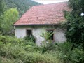
|  Staudenhof - Mauel - Eifel - Germany Staudenhof - Mauel - Eifel - Germany
in Unoccupied Buildings, Shacks, and Cabins A hard to find ghosttown in the Eifelregion in Germany. In former times about 100 citizens. Last citizens left the village in 1990. posted by: eilers1 location: Rheinland-Pfalz, Germany date approved: 07/24/2015 last visited: 07/24/2015 |
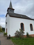
 view gallery view galleryN10.9 km | St. Jesu Namen, Wascheid, RLP, Germany in Roman Catholic Churches Kapelle in Wascheid
Chapel in Wascheid posted by: Tillba location: Rheinland-Pfalz, Germany date approved: 10/21/2022 last visited: never |
 view gallery view galleryN10.9 km |  St. Jesu Namen, Gondenbrett-Wascheid, RLP, Germany St. Jesu Namen, Gondenbrett-Wascheid, RLP, Germany
in Deutsche Denkmallisten - German Monument Registers Kapelle in Wascheid Chapel in Wascheid posted by: Tillba location: Rheinland-Pfalz, Germany date approved: 10/17/2022 last visited: never |
 view gallery view galleryN11.3 km |  UTM 313656 / 5570228, Gondenbrett, Germany UTM 313656 / 5570228, Gondenbrett, Germany
in Permanent Geographic Coordinates Wegweiser im Wandergebiet Schwarzer Mann
Signposts in the Schwarzer Mann hiking area posted by: Tillba location: Rheinland-Pfalz, Germany date approved: 10/19/2022 last visited: never |
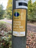
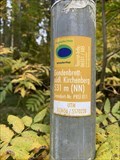 view gallery view galleryN11.3 km |  Gondenbrett: südl. Kirchenberg, Gondenbrett, Germany - 531m (NN) Gondenbrett: südl. Kirchenberg, Gondenbrett, Germany - 531m (NN)
in Elevation Signs Höhenangabe Schwarzer Mann
Height indication Schwarzer Mann posted by: Tillba location: Rheinland-Pfalz, Germany date approved: 10/18/2022 last visited: never |
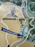 view gallery view galleryN11.6 km | Wandern und erholen (Wanderkarte), Wascheid, RLP, Germany in 'You Are Here' Maps Wanderkarte am Wascheider Stausee
Hiking map at the Wascheider Reservoir posted by: Tillba location: Rheinland-Pfalz, Germany date approved: 10/01/2022 last visited: never |
 view gallery view galleryN11.6 km |  Stausee Wascheid, Gondenbrett-Wascheid, RLP, Germany Stausee Wascheid, Gondenbrett-Wascheid, RLP, Germany
in Water Dams Kleiner Stausee am Fuß der Schneifel
Small reservoir at the foot of the Schneifel posted by: Tillba location: Rheinland-Pfalz, Germany date approved: 10/05/2022 last visited: never |
 view gallery view galleryN11.7 km | Schwarzer Mann, Schneifel/ Wascheid, Germany - 550m (NN) in Elevation Signs Höhenangabe Schwarzer Mann
Height indication Schwarzer Mann posted by: Tillba location: Rheinland-Pfalz, Germany date approved: 10/14/2022 last visited: never |
 view gallery view galleryN11.7 km | UTM 313847/ 5570744, Wascheid, Germany in Permanent Geographic Coordinates Wegweiser im Wandergebiet Schwarzer Mann
Signposts in the Schwarzer Mann hiking area posted by: Tillba location: Rheinland-Pfalz, Germany date approved: 10/14/2022 last visited: never |
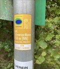
 view gallery view galleryN12.1 km | Abzweig Sellerich, Gondenbrett, Germany - 601m (NN) in Elevation Signs Höhenangabe Abzweig Sellerich
Height indication Abzweig Sellerich posted by: Tillba location: Rheinland-Pfalz, Germany date approved: 10/18/2022 last visited: never |
 view gallery view galleryN12.1 km | UTM 313244 / 5570835, Gondenbrett, Germany in Permanent Geographic Coordinates Wegweiser im Wandergebiet Schwarzer Mann
Signposts in the Schwarzer Mann hiking area posted by: Tillba location: Rheinland-Pfalz, Germany date approved: 10/19/2022 last visited: never |
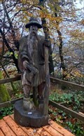 view gallery view galleryN12.1 km |  Schwarzer Mann, Schneifel, Sellerich, RLP, Germany Schwarzer Mann, Schneifel, Sellerich, RLP, Germany
in Outside Wooden Display Carvings Holzfigur auf einer der höchsten Erhebungen in der Eifel / Wooden figure on one of the highest elevations in the Eifel (698 m). posted by: Tillba location: Rheinland-Pfalz, Germany date approved: 09/19/2022 last visited: never |
|