 view gallery view gallery E2.7 km E2.7 km
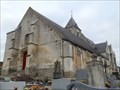
|   Eglise cimetière de Naours, Naours, Somme, France Eglise cimetière de Naours, Naours, Somme, France
in Worldwide Cemeteries rue de Fossé de l'Église posted by:  elyob elyob location: Hauts-de-France, France date approved: 11/05/2016 last visited: never |
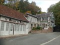 view gallery view galleryE3.2 km | ") Cité souterraine de Naours, Somme, France Cité souterraine de Naours, Somme, France
in Cave Entrances (Artificial) 5 Rue des Carrières, 80260 Naours posted by: elyob location: Hauts-de-France, France date approved: 12/19/2016 last visited: 07/12/2020 |
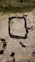 view gallery view galleryE3.2 km |  La Cité Souterraine de Naours - Naours, France La Cité Souterraine de Naours - Naours, France
in Paleontology and Fossils [FR] La cité souterraine est creusée dans la craie du Crétacé supérieur, riche en fossiles d'oursins, de bivalves et d'ammonites. [EN] The underground city is dug into Upper Cretaceouse limestone rich in urchins, bi-valves and ammonites. posted by: RakeInTheCache location: Hauts-de-France, France date approved: 08/08/2020 last visited: never |
 view gallery view galleryE3.2 km |  La Cité Souterraine de Naours - Naours, France La Cité Souterraine de Naours - Naours, France
in Official Local Tourism Attractions [FR] La cité souterraine de Naours est un ancien habitat souterrain développant plus de 2 000 mètres de galeries. [EN] It is literally an ancient underground city whose entrance was "closed" and was restored by the parish priest in 1887. posted by: RakeInTheCache location: Hauts-de-France, France date approved: 08/07/2020 last visited: never |
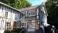
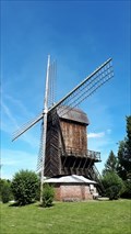 view gallery view galleryE3.4 km |  Moulin du Belcan - Naours, France Moulin du Belcan - Naours, France
in Windmills [FR] Le moulin du Belcan était un moulin à huile qui existait avant la Révolution française. [EN] The Belcan windmill produced oil and dates before the French Revovlution. posted by: RakeInTheCache location: Hauts-de-France, France date approved: 07/19/2020 last visited: never |
 view gallery view gallery SE4 km SE4 km
|  Le blason de pierre de la commune - Flesselles, France Le blason de pierre de la commune - Flesselles, France
in Coats of Arms Le blason, installé sur la façade de la mairie annexe située derrière l'église, a été sculpté en 1997 par A. PETIT. posted by: esslpt02100 location: Hauts-de-France, France date approved: 08/24/2018 last visited: never |
 view gallery view gallery NE5.3 km NE5.3 km
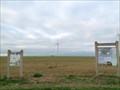
| Parc Eolien du Magremont - Naours, Somme, France in Windmills Départementale route D117 posted by: elyob location: Hauts-de-France, France date approved: 11/18/2016 last visited: never |
 view gallery view gallery W11.3 km W11.3 km
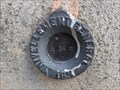
|  Repère de Nivellement - Église Saint-Léger - Flixecourt, France Repère de Nivellement - Église Saint-Léger - Flixecourt, France
in French Benchmarks Le Repère Cylindrique du Nivellement Général se situe sur le contrefort est du mur de façade nord de la nef, sur la face est. posted by: pmaupin location: Hauts-de-France, France date approved: 02/14/2023 last visited: 02/14/2023 |
 view gallery view galleryW11.3 km |  Église Saint-Léger - Flixecourt, France Église Saint-Léger - Flixecourt, France
in Wikipedia Entries [EN] The Saint-Léger church is oriented north-south; the main entrance to the north, facing the village.
[FR] L'église Saint-Léger est orientée nord-sud ; l'entrée principale au nord, tournée vers le village. posted by: pmaupin location: Hauts-de-France, France date approved: 02/14/2023 last visited: 02/14/2023 |
 view gallery view galleryW11.3 km |  Église Saint-Léger - Flixecourt, France Église Saint-Léger - Flixecourt, France
in This Old Church [EN] The Saint-Léger church is oriented north-south; the main entrance to the north, facing the village. [FR] L'église Saint-Léger est orientée nord-sud ; l'entrée principale au nord, tournée vers le village. posted by: pmaupin location: Hauts-de-France, France date approved: 02/15/2023 last visited: 02/14/2023 |
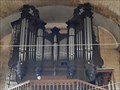 view gallery view galleryW11.3 km |  L'Orgue de l'Église Saint-Léger - Flixecourt, France L'Orgue de l'Église Saint-Léger - Flixecourt, France
in Musical Instruments [EN] The church received important old furniture such as the organ case of the abbey of Berteaucourt-les-Dames.
[FR] L'église a reçu un important mobilier ancien comme le buffet d'orgue de l'abbaye de Berteaucourt-les-Dames. posted by: pmaupin location: Hauts-de-France, France date approved: 02/16/2023 last visited: 02/16/2023 |
 view gallery view galleryW11.3 km | Église Saint-Léger - Flixecourt, France in Roman Catholic Churches [EN] The Saint-Léger church is oriented north-south; the main entrance to the north, facing the village. [FR] L'église Saint-Léger est orientée nord-sud ; l'entrée principale au nord, tournée vers le village. posted by: pmaupin location: Hauts-de-France, France date approved: 02/15/2023 last visited: 02/14/2023 |
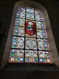 view gallery view galleryW11.3 km |  Les Vitraux de l'Église Saint-Léger - Flixecourt, France Les Vitraux de l'Église Saint-Léger - Flixecourt, France
in Stained Glass Windows [EN] The Saint-Léger church is oriented north-south; the main entrance to the north, facing the village. [FR] L'église Saint-Léger est orientée nord-sud ; l'entrée principale au nord, tournée vers le village. posted by: pmaupin location: Hauts-de-France, France date approved: 02/17/2023 last visited: 02/17/2023 |
 view gallery view galleryW11.3 km |  Le Clocher de l'Église Saint-Léger - Flixecourt, France Le Clocher de l'Église Saint-Léger - Flixecourt, France
in Bell Towers [EN] The Saint-Léger church is oriented north-south; the main entrance to the north, facing the village. [FR] L'église Saint-Léger est orientée nord-sud ; l'entrée principale au nord, tournée vers le village. posted by: pmaupin location: Hauts-de-France, France date approved: 02/14/2023 last visited: 02/14/2023 |
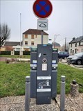 view gallery view galleryW11.3 km |  Station de rechargement électrique, Rue de Strasbourg- Flixecourt, France Station de rechargement électrique, Rue de Strasbourg- Flixecourt, France
in Electric Car Charging Stations [EN] Charging station for electric vehicles in the parking lot of the war memorial, rue de strasbourg.
[FR] Borne de recharge pour véhicule électrique sur le parking du monument aux Morts, rue de strasbourg. posted by: pmaupin location: Hauts-de-France, France date approved: 02/17/2023 last visited: 02/17/2023 |
 view gallery view galleryW11.4 km |  Usine Saint-Frères - Flixecourt, France Usine Saint-Frères - Flixecourt, France
in Monuments Historiques Français [FR] Saint Frères est le nom d'une entreprise textile spécialisée dans le tissage de la toile de jute.
[EN] Saint Frères is the name of a textile company specializing in the weaving of hessian. posted by: pmaupin location: Hauts-de-France, France date approved: 02/14/2023 last visited: 02/14/2023 |
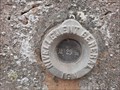 view gallery view galleryW11.9 km | Repère de Nivellement - Château de la Navette - Flixecourt, France in French Benchmarks Le Repère Cylindrique du Nivellement Général se situe sur le soubassement du pilier sud-ouest, face sud-est, face à la route, à l'axe. posted by: pmaupin location: Hauts-de-France, France date approved: 02/13/2023 last visited: 02/13/2023 |
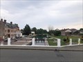
 view gallery view galleryW11.9 km |  Château de la Navette - Flixecourt, France Château de la Navette - Flixecourt, France
in Castles [EN]The residence occupies a steeply sloping site bordering the Route de L'Étoile, at the western exit of the town of Flixecourt
[FR]La demeure occupe un site en forte déclivité bordant la route de L'Étoile, à la sortie ouest du bourg de Flixecourt posted by: pmaupin location: Hauts-de-France, France date approved: 02/13/2023 last visited: 02/13/2023 |
 view gallery view galleryW11.9 km | Chateau de la Navette - Flixecourt, France in Wikipedia Entries FR- Le château de la Navette est un château situé sur le territoire de la commune de Flixecourt. Propriété d'une personne privée.
EN- The Navette castle is a castle located on the territory of the town of Flixecourt. Property of a private person. posted by: geotrouvtou59 location: Hauts-de-France, France date approved: 02/18/2020 last visited: 02/13/2023 |
 view gallery view galleryW11.9 km | Château de la Navette - Flixecourt, France in Monuments Historiques Français Le château de la Navette est un château situé sur le territoire de la commune de Flixecourt.
Propriété d'une personne privée posted by: geotrouvtou59 location: Hauts-de-France, France date approved: 08/15/2018 last visited: 02/13/2023 |
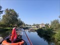
 view gallery view gallery SW12.1 km SW12.1 km
|  Écluse 20 Picquigny - Canal de la Somme - Picquigny - Somme 80 - France Écluse 20 Picquigny - Canal de la Somme - Picquigny - Somme 80 - France
in Waterway Locks, Planes and Lifts This is lock number 20 on the Canal de la Somme and is known as Picquigny. posted by: ntpayne location: Hauts-de-France, France date approved: 11/25/2020 last visited: never |
 view gallery view gallery S12.1 km S12.1 km
| Écluse 19 Ailly - Canal de la Somme - Ailly-sur-Somme - Somme 80 - France in Waterway Locks, Planes and Lifts This is lock number 19 on the Canal de la Somme and is known as Ailly. posted by: ntpayne location: Hauts-de-France, France date approved: 11/25/2020 last visited: never |
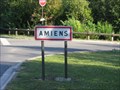 view gallery view galleryS12.7 km |  Amiens (Somme) - France Amiens (Somme) - France
in In Search of the Celts [FR] Amiens est issu du nom du peuple gaulois local, les Ambiani. [EN] Amiens was the central settlement of the Ambiani, one of the principal tribes of Gaul. posted by: RakeInTheCache location: Hauts-de-France, France date approved: 08/06/2011 last visited: 01/26/2016 |
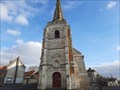 view gallery view gallerySW12.7 km | Église Saint-Martin - Bourdon, France in Wikipedia Entries [EN] At the crossroads, it captivates the eye with each new passage.
[FR] À la croisée des routes, elle captive le regard à chaque nouveau passage. posted by: pmaupin location: Hauts-de-France, France date approved: 02/11/2023 last visited: 02/11/2023 |
 view gallery view gallerySW12.7 km | Église Saint-Martin - Bourdon, France in This Old Church [EN] At the crossroads, it captivates the eye with each new passage.
[FR] À la croisée des routes, elle captive le regard à chaque nouveau passage. posted by: pmaupin location: Hauts-de-France, France date approved: 02/11/2023 last visited: 02/11/2023 |
|