 view gallery view gallery SW3.2 km SW3.2 km
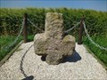
|   Croix de Chemin - Capval, France Croix de Chemin - Capval, France
in Christian Crosses Cross @ the crossing between Wanchy-Capval and Les Vieux Ifs. posted by:  GEOrgCACHING GEOrgCACHING location: Normandie, France date approved: 06/16/2023 last visited: never |
 view gallery view gallery NE8.5 km NE8.5 km
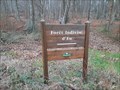
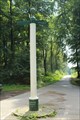
|  Site V1 Poteau de Montauban Site V1 Poteau de Montauban
in World War II Sites From here (together with the Mt Gournoy site at Aubermesnil-aux-Érables and Rétonval) the first V1 rockets were fired in Seine-Maritime during June 1944. posted by: GEOrgCACHING location: Normandie, France date approved: 06/05/2023 last visited: never |
 view gallery view gallery N8.9 km N8.9 km
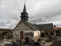
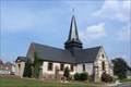
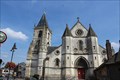
|  Église Notre-Dame - Cuverville-sur-Yères, France Église Notre-Dame - Cuverville-sur-Yères, France
in Medieval Churches [EN] Belonging to an old barony dating from the 11th century, the Notre-Dame church has been a very important place of pilgrimage since the plague epidemic in 1636.
[FR] Appartenant à une ancienne baronnie datant du XIe siècle, l’église Notre-Dame est un lieu de pèlerinage très important depuis l’épidémie de peste en 1636. posted by: pmaupin location: Normandie, France date approved: 12/22/2020 last visited: 10/22/2020 |
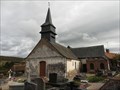
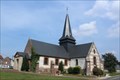
 view gallery view galleryN8.9 km |  Église Notre-Dame - Cuverville-sur-Yères, France Église Notre-Dame - Cuverville-sur-Yères, France
in This Old Church [EN] Belonging to an old barony dating from the 11th century, the Notre-Dame church has been a very important place of pilgrimage since the plague epidemic in 1636. [FR] Appartenant à une ancienne baronnie datant du XIe siècle, l’église Notre-Dame est un lieu de pèlerinage très important depuis l’épidémie de peste en 1636. posted by: pmaupin location: Normandie, France date approved: 12/22/2020 last visited: 10/22/2020 |
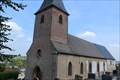
 view gallery view galleryN8.9 km | Église Notre-Dame - Cuverville-sur-Yères, France in Roman Catholic Churches [EN] Belonging to an old barony dating from the 11th century, the Notre-Dame church has been a very important place of pilgrimage since the plague epidemic in 1636. [FR] Appartenant à une ancienne baronnie datant du XIe siècle, l’église Notre-Dame est un lieu de pèlerinage très important depuis l’épidémie de peste en 1636. posted by: pmaupin location: Normandie, France date approved: 12/22/2020 last visited: 10/22/2020 |
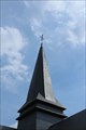
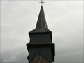 view gallery view galleryN8.9 km |  Le Clocher de l'Église Notre-Dame - Cuverville-sur-Yères, France Le Clocher de l'Église Notre-Dame - Cuverville-sur-Yères, France
in Bell Towers [EN] Belonging to an old barony dating from the 11th century, the Notre-Dame church has been a very important place of pilgrimage since the plague epidemic in 1636. [FR] Appartenant à une ancienne baronnie datant du XIe siècle, l’église Notre-Dame est un lieu de pèlerinage très important depuis l’épidémie de peste en 1636. posted by: pmaupin location: Normandie, France date approved: 12/24/2020 last visited: 10/22/2020 |
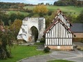 view gallery view galleryN8.9 km |  Vestiges des remparts d'un Château - Cuverville-sur-Yères, France Vestiges des remparts d'un Château - Cuverville-sur-Yères, France
in Preserved Architectural Remnants and Ruins [EN] In Cuverville-sur-Yères, there are the ruins of a fortified castle.
[FR] À Cuverville-sur-Yères, on trouve les ruines d'un château-fort. posted by: pmaupin location: Normandie, France date approved: 01/15/2021 last visited: 10/22/2020 |
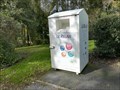
 view gallery view galleryN9 km |  DO -- Rue de la Motte Féodale - Cuverville-sur-Yères, France DO -- Rue de la Motte Féodale - Cuverville-sur-Yères, France
in Places for Recycling [EN] Recycling point for glass. [FR] Point de recyclage pour le verre. posted by: pmaupin location: Normandie, France date approved: 12/25/2020 last visited: 10/22/2020 |
 view gallery view galleryN9 km |  Box de collecte de vêtements "Le Relais" - Cuverville-sur-Yères, France Box de collecte de vêtements "Le Relais" - Cuverville-sur-Yères, France
in Permanent Charity Donation Locations [EN] Box of clothing collection, shoes, linen, small leather goods, in good condition.
[FR] Box de collecte de vêtements, chaussures, linge de maison, petite maroquinerie, en bon état. posted by: pmaupin location: Normandie, France date approved: 12/24/2020 last visited: 10/22/2020 |
 view gallery view gallery E12.2 km E12.2 km
|  Le Poteau du Carrefour Maître Jean dans la forêt d'Eu - 1876-1998 - Monchy-sur-Eu, France Le Poteau du Carrefour Maître Jean dans la forêt d'Eu - 1876-1998 - Monchy-sur-Eu, France
in Dated Architectural Structures Multifarious [EN] This post located in the forest of Eu at the crossroads Master Jean dates from 1876.
[FR] Ce poteau situé en foret d'Eu au niveau du carrefour Maître Jean date de 1876. posted by: pmaupin location: Normandie, France date approved: 05/14/2018 last visited: 05/12/2018 |
 view gallery view galleryE12.2 km |  Forêt d'Eu - Blangy-sur-Bresle, France Forêt d'Eu - Blangy-sur-Bresle, France
in Wikipedia Entries [EN] The Eu forest is one of the great forests of Seine-Maritime, in Normandy.
[FR] La forêt d'Eu est une des grandes forêts de Seine-Maritime, en Normandie. posted by: pmaupin location: Normandie, France date approved: 01/27/2023 last visited: 01/27/2023 |
 view gallery view galleryE12.2 km |  Forêt d'Eu - Blangy-sur-Bresle, France Forêt d'Eu - Blangy-sur-Bresle, France
in Official Local Tourism Attractions [EN] The Eu forest is one of the great forests of Seine-Maritime, in Normandy. [FR] La forêt d'Eu est une des grandes forêts de Seine-Maritime, en Normandie. posted by: pmaupin location: Normandie, France date approved: 01/29/2023 last visited: 01/29/2023 |
 view gallery view galleryE12.2 km |  Forêt d'Eu - Blangy-sur-Bresle, France Forêt d'Eu - Blangy-sur-Bresle, France
in Public Access Lands [EN] The Eu forest is one of the great forests of Seine-Maritime, in Normandy. [FR] La forêt d'Eu est une des grandes forêts de Seine-Maritime, en Normandie. posted by: pmaupin location: Normandie, France date approved: 01/29/2023 last visited: 01/29/2023 |
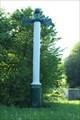
 view gallery view galleryN12.4 km |  Benchmark - Eglise Saint-Riquier - Monchy-sur-Eu, France Benchmark - Eglise Saint-Riquier - Monchy-sur-Eu, France
in French Benchmarks Le Repère Cylindrique du Nivellement Général se situe sur le soubassement du mur de façade Sud de la nef de l'église, face à la route. posted by: pmaupin location: Normandie, France date approved: 08/31/2017 last visited: 08/28/2017 |
 view gallery view galleryN12.4 km | L'Eglise Saint-Riquier - Monchy sur Eu, France in Roman Catholic Churches [EN] The St Riquier church of the XVIIth in a small village, in Normandy, of 592 inhabitants. [FR] L'église St Riquier du XVIIème dans un petit village, en Normandie, de 592 habitants. posted by: pmaupin location: Normandie, France date approved: 05/06/2018 last visited: 08/28/2017 |
 view gallery view galleryN12.4 km | Le Clocher de l'Eglise Saint-Riquier - Monchy sur Eu, France in Bell Towers [EN] The St Riquier church of the XVIIth in a small village, in Normandy, of 592 inhabitants.
[FR] L'église St Riquier du XVIIème dans un petit village, en Normandie, de 592 habitants. posted by: pmaupin location: Normandie, France date approved: 09/03/2017 last visited: 08/28/2017 |
 view gallery view galleryN12.4 km | L'Eglise Saint-Riquier - Monchy sur Eu, France in This Old Church [EN] The St Riquier church of the XVIIth in a small village, in Normandy, of 592 inhabitants.
[FR] L'église St Riquier du XVIIème dans un petit village, en Normandie, de 592 habitants. posted by: pmaupin location: Normandie, France date approved: 09/03/2017 last visited: 08/28/2017 |
 view gallery view galleryNE13.8 km | Eglise Saint-Clément - Longroy, France in This Old Church [EN] The church of the small village of Longroy, 640 inhabitants, is placed on the slope of a hill. [FR] L'église du petit village de Longroy, 640 habitants, est placée sur le penchant d'une colline posted by: pmaupin location: Normandie, France date approved: 05/05/2018 last visited: 08/28/2017 |
 view gallery view galleryNE13.8 km | Eglise Saint-Clément - Longroy, France in Roman Catholic Churches [EN] The church of the small village of Longroy, 640 inhabitants, is placed on the slope of a hill.
[FR] L'église du petit village de Longroy, 640 habitants, est placée sur le penchant d'une colline posted by: pmaupin location: Normandie, France date approved: 05/06/2018 last visited: 08/28/2017 |
 view gallery view galleryN13.8 km | Le Poteau du Carrefour Isabelle dans la forêt d'Eu - 1897 - Monchy-sur-Eu, France in Dated Architectural Structures Multifarious [EN] This post located in the forest of Eu at the crossroads Isabelle dates from 1897.
[FR] Ce poteau situé en foret d'Eu au niveau du carrefour Isabelle date de 1897. posted by: pmaupin location: Normandie, France date approved: 09/03/2017 last visited: 08/30/2017 |
 view gallery view galleryN13.8 km |  Le Poteau Isabelle dans la forêt d'Eu - Monchy-sur-Eu, France Le Poteau Isabelle dans la forêt d'Eu - Monchy-sur-Eu, France
in Direction and Distance Arrows [EN] This post located in the forest of Eu at the crossroads Isabelle dates from 1897.
[FR] Ce poteau situé en foret d'Eu au niveau du carrefour Isabelle date de 1897. posted by: pmaupin location: Normandie, France date approved: 09/11/2017 last visited: 09/16/2017 |
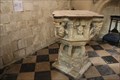 view gallery view galleryNE14.3 km |  Les Fonts Baptismaux - Église Saint-Pierre-et-Saint-Paul - Gamaches, France Les Fonts Baptismaux - Église Saint-Pierre-et-Saint-Paul - Gamaches, France
in Stone Church Artefacts [EN] The Baptismal Fonts are located in a small chapel on the left entering the Church of St. Peter and St. Paul of Gamaches.
[FR] Les Fonts baptismaux sont situés dans une petite chapelle à gauche en entrant dans l'Église Saint-Pierre-et-Saint-Paul de Gamaches. posted by: pmaupin location: Hauts-de-France, France date approved: 05/06/2018 last visited: 08/29/2017 |
 view gallery view galleryNE14.3 km | Église Saint-Pierre-et-Saint-Paul - Gamaches, France in This Old Church [EN] The church of Gamaches was built in the thirteenth century, devastated by the troops of the Duke of Burgundy Charles the Bold [FR]L'église de Gamaches fut édifiée au XIIIe siècle, dévastée par les troupes du duc de Bourgogne Charles le Téméraire posted by: pmaupin location: Hauts-de-France, France date approved: 08/30/2017 last visited: 08/29/2017 |
 view gallery view galleryNE14.3 km | Église Saint-Pierre-et-Saint-Paul - Gamaches, France in Medieval Churches [EN] The church of Gamaches was built in the thirteenth century, devastated by the troops of the Duke of Burgundy Charles the Bold [FR]L'église de Gamaches fut édifiée au XIIIe siècle, dévastée par les troupes du duc de Bourgogne Charles le Téméraire posted by: pmaupin location: Hauts-de-France, France date approved: 09/01/2017 last visited: 08/29/2017 |
 view gallery view galleryNE14.3 km | Église Saint-Pierre-et-Saint-Paul - Gamaches, France in Wikipedia Entries {EN] The church of Gamaches was built in the thirteenth century, devastated by the troops of the Duke of Burgundy Charles the Bold
[FR]L'église de Gamaches fut édifiée au XIIIe siècle, dévastée par les troupes du duc de Bourgogne Charles le Téméraire posted by: pmaupin location: Hauts-de-France, France date approved: 08/30/2017 last visited: 08/29/2017 |
|