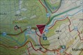
 view gallery view gallery E4.8 km E4.8 km
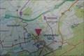
|   Ihr Standort - Mühlental Hütte - Mandern, Germany Ihr Standort - Mühlental Hütte - Mandern, Germany
in 'You Are Here' Maps Ihr Standort marker on a map in front of the Mühlental Hütte located at Mühlenweg in Mandern, Germany. posted by:  dreamhummie dreamhummie location: Rheinland-Pfalz, Germany date approved: 09/13/2023 last visited: never |
 view gallery view gallery W4.8 km W4.8 km
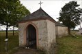
|  Das Speiner Bildchen - Irsch, Germany Das Speiner Bildchen - Irsch, Germany
in Waychapels A chapel called "Das Speiner Bildchen" along the B407 between Zerf and Irsch, Germany. posted by: dreamhummie location: Rheinland-Pfalz, Germany date approved: 01/08/2023 last visited: never |
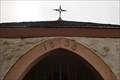 view gallery view galleryW4.8 km |  1838 - Das Speiner Bildchen - Irsch, Germany 1838 - Das Speiner Bildchen - Irsch, Germany
in Dated Buildings and Cornerstones A chapel called "Das Speiner Bildchen" along the B407 between Zerf and Irsch, Germany. posted by: dreamhummie location: Rheinland-Pfalz, Germany date approved: 01/18/2023 last visited: never |
 view gallery view galleryW4.8 km |  Das Speiner Bildchen - Irsch, Deutschland Das Speiner Bildchen - Irsch, Deutschland
in Deutsche Denkmallisten - German Monument Registers Das Speiner Bildchen, ein Kapelle an der B407 zwischen Zerf und Irsch, Deutschland. posted by: dreamhummie location: Rheinland-Pfalz, Germany date approved: 09/15/2022 last visited: never |
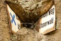
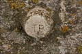 view gallery view galleryW4.8 km |  TP - Das Speiner Bildchen - Irsch, Germany TP - Das Speiner Bildchen - Irsch, Germany
in German Trigonometric Points TP Bolt on the Marian chapel "Das Speiner Bildchen" located along the B407 between Zerf and Irsch, Germany. posted by: dreamhummie location: Rheinland-Pfalz, Germany date approved: 09/15/2022 last visited: never |
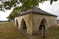 view gallery view galleryW4.8 km | Der Stall - Irsch, Deutschland in Deutsche Denkmallisten - German Monument Registers Der Stall, ein Viehunterstand neben der Kapelle an der B407 zwischen Zerf und Irsch, Deutschland. posted by: dreamhummie location: Rheinland-Pfalz, Germany date approved: 09/15/2022 last visited: never |
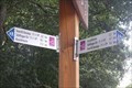 view gallery view galleryE5.1 km |  Direction and Distance Arrows - Schillingen, Germany Direction and Distance Arrows - Schillingen, Germany
in Direction and Distance Arrows Direction and Distance Arrows at the entreance of Freizeitanlage Schillinger See in the outskirts of Schillingen, Germany. posted by: dreamhummie location: Rheinland-Pfalz, Germany date approved: 09/18/2023 last visited: never |
 view gallery view galleryE5.1 km | Ihr Standort - Freizeitanlage Schillinger See - Schillingen, Germany in 'You Are Here' Maps Ihr Standort marker on a map at a parking lot at Freizeitanlage Schillinger See near Schillingen, Germany. posted by: dreamhummie location: Rheinland-Pfalz, Germany date approved: 09/12/2023 last visited: never |
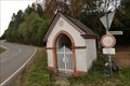
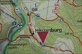 view gallery view gallery NE5.6 km NE5.6 km
| Ihr Standort - Hinzenburg, Germany in 'You Are Here' Maps Ihr Standort marker on a map at a parking lot along the Kellerstraße in Hinzenburg, Germany. posted by: dreamhummie location: Rheinland-Pfalz, Germany date approved: 09/12/2023 last visited: never |
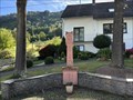
 view gallery view galleryE5.8 km |  Brunnen - Schillingen, Germany Brunnen - Schillingen, Germany
in Fountains Fountain (Brunnen), west of the village on the road leading to Fatima Chapel, Schillingen, Germany. posted by: dreamhummie location: Rheinland-Pfalz, Germany date approved: 09/13/2023 last visited: never |
 view gallery view galleryE7.6 km | Ihr Standort - Kirche - Waldweiler, Germany in 'You Are Here' Maps Ihr Standort marker on a map behind the Church located at Hauptstraße in Waldweiler, Germany. posted by: dreamhummie location: Rheinland-Pfalz, Germany date approved: 09/13/2023 last visited: never |
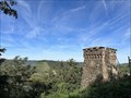
 view gallery view gallery SW7.7 km SW7.7 km
|  Roman Forest ? - Serrig, Germany Roman Forest ? - Serrig, Germany
in Omnivorous Trees Eaten up information sign at a viewpoint over the Saar near Serrig, Germany. posted by: dreamhummie location: Rheinland-Pfalz, Germany date approved: 08/06/2022 last visited: never |
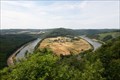 view gallery view gallerySW7.7 km |  Overview Saar Valley - Serrig, Germany Overview Saar Valley - Serrig, Germany
in Scenic Roadside Look-Outs Scenic overview over the Saar River along the K139 near Serrig, Germany. posted by: dreamhummie location: Rheinland-Pfalz, Germany date approved: 08/08/2022 last visited: never |
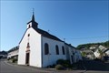
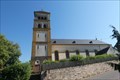 view gallery view galleryNE7.7 km |  Katholische Pfarrkirche St. Andreas - Schöndorf, Germany Katholische Pfarrkirche St. Andreas - Schöndorf, Germany
in This Old Church Katholische Pfarrkirche St. Andreas located at Hauptstraße in Schöndorf, Germany. posted by: dreamhummie location: Rheinland-Pfalz, Germany date approved: 06/18/2023 last visited: never |
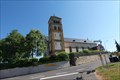 view gallery view galleryNE7.7 km | Katholische Pfarrkirche St. Andreas - Schöndorf, Deutschland in Deutsche Denkmallisten - German Monument Registers Katholische Pfarrkirche St. Andreas am Hauptstraße in Schöndorf, Deutschland. posted by: dreamhummie location: Rheinland-Pfalz, Germany date approved: 06/15/2023 last visited: never |
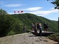 view gallery view gallerySW7.7 km |  Schoene Aussicht (Hang glider launching platform) - Serrig, Germany Schoene Aussicht (Hang glider launching platform) - Serrig, Germany
in Web Cameras A webcam at a famous view and the hang glider launching platform in Serrig, Germany.
Eine Webcam an einer berühmten Aussicht und einem Drachenflieger-Startpunkt bei Serrig. posted by: kukus location: Rheinland-Pfalz, Germany date approved: 07/11/2017 last visited: 06/22/2022 |
 view gallery view galleryW8.2 km |  Maria Johannes - Schoden, Germany Maria Johannes - Schoden, Germany
in Wayside shrines Historic Wayside Shrine. posted by: flyingmoose location: Rheinland-Pfalz, Germany date approved: 01/30/2024 last visited: never |
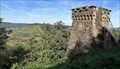 view gallery view galleryW8.4 km |  Bismarck Tower - Rheinland-Pfalz, Germany Bismarck Tower - Rheinland-Pfalz, Germany
in Bismarck Towers Bismarck tower overlooking the Saar Valley. posted by: flyingmoose location: Rheinland-Pfalz, Germany date approved: 10/22/2023 last visited: never |
 view gallery view galleryW8.4 km |  Bismarck Tower - Rheinland-Pfalz, Germany Bismarck Tower - Rheinland-Pfalz, Germany
in Look-Out Towers Bismarck tower overlooking the Saar Valley. posted by: flyingmoose location: Rheinland-Pfalz, Germany date approved: 01/27/2024 last visited: never |
 view gallery view galleryE8.5 km | Flurkapelle Mühlscheid - Waldweiler, Germany in Waychapels A chapel called "Flurkapelle Mühlscheid" along the B407, at the exit Mühlscheiderhof, near Waldweiler, Germany. posted by: dreamhummie location: Rheinland-Pfalz, Germany date approved: 01/14/2023 last visited: never |
 view gallery view galleryE8.5 km | Flurkapelle Mühlscheid - Waldweiler, Deutschland in Deutsche Denkmallisten - German Monument Registers Flurkapelle an der Abzweigung der Bundesstraße 407 zum nahegelegenen Mühlscheiderhof in die nahe von Waldweiler, Deutschland. posted by: dreamhummie location: Rheinland-Pfalz, Germany date approved: 01/14/2023 last visited: never |
 view gallery view galleryNE8.5 km | Katholische Filialkirche St. Helena - Holzerath, Germany in This Old Church Katholische Filialkirche St. Helena located at Römerstraße 15 in Holzerath, Germany. posted by: dreamhummie location: Rheinland-Pfalz, Germany date approved: 06/18/2023 last visited: never |
 view gallery view galleryNE8.5 km | Katholische Filialkirche St. Helena - Holzerath, Deutschland in Deutsche Denkmallisten - German Monument Registers Katholische Filialkirche St. Helena am Römerstraße 15 in Holzerath, Deutschland. posted by: dreamhummie location: Rheinland-Pfalz, Germany date approved: 06/15/2023 last visited: never |
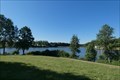 view gallery view galleryE8.7 km |  Keller Stausee - Kell am See, Germany Keller Stausee - Kell am See, Germany
in Wikipedia Entries Keller Stausee, a lake near Kell am See, Germany. posted by: dreamhummie location: Rheinland-Pfalz, Germany date approved: 06/18/2023 last visited: never |
 view gallery view galleryE8.7 km | Direction and Distance Arrows # Saar-Hunsrück Steig - Kell am See, Germany in Direction and Distance Arrows Direction and distance arrows of the Saar-Hunsrück Steig at Ferienpark Hochwald in Kell am See, Germany. posted by: dreamhummie location: Rheinland-Pfalz, Germany date approved: 06/27/2023 last visited: never |
|