 view gallery view gallery NW4 km NW4 km
|   Porteau Cove Provincial Park — Porteau Cove, BC Porteau Cove Provincial Park — Porteau Cove, BC
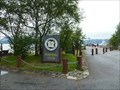
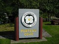
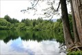
in Grand Opening Porteau Cove Provincial Park is sliver of land between the Canadian National Railway and the shores of Howe Sound. In this small area is a campground and a world famous scuba diving park. It was opened on July 28, 1981. posted by:  Dunbar Loop Dunbar Loop location: British Columbia, Canada date approved: 06/25/2016 last visited: never |
 view gallery view galleryNW4.2 km |  Porteau Cove Provincial Park Campground, BC Porteau Cove Provincial Park Campground, BC
in Campgrounds Small but close to Vancouver. posted by:  gypsie2 gypsie2 location: British Columbia, Canada date approved: 10/17/2012 last visited: never |
 view gallery view galleryNW4.2 km |  Porteau Cove Pier, Porteau Cove BC Porteau Cove Pier, Porteau Cove BC
in Piers Pier at Porteau Cove Provincial Park, north of Vancouver, BC. posted by: gypsie2 location: British Columbia, Canada date approved: 10/15/2012 last visited: 08/19/2010 |
 view gallery view galleryNW4.2 km |  Porteau Cove Provincial Park - British Columbia Porteau Cove Provincial Park - British Columbia
in State/Provincial Parks Small provincial park on the Sea to Sky Highway between Vancouver and Whistler, BC. posted by: gypsie2 location: British Columbia, Canada date approved: 10/22/2012 last visited: 06/04/2002 |
 view gallery view galleryNW4.2 km |  Porteau Cove, B.C., Canada Porteau Cove, B.C., Canada
in Dive Sites Porteau Cove is one of the best dives within a half hour of Vancouver, and is also one of the popular British Columbia artificial reefs. posted by: grafinator location: British Columbia, Canada date approved: 08/23/2012 last visited: 09/25/2012 |
 view gallery view gallery N6.8 km N6.8 km
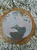
|  British Columbia Legal Survey - 2000 WT R R/W 661 British Columbia Legal Survey - 2000 WT R R/W 661
in Canadian Benchmarks Located on top of a boulder on the beach. Nice view of Howe Sound at this location. posted by: grafinator location: British Columbia, Canada date approved: 04/22/2013 last visited: 11/02/2013 |
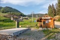
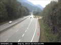 view gallery view galleryN7.4 km |  Hwy 99 at Furry Creek Webcam - Squamish, BC Hwy 99 at Furry Creek Webcam - Squamish, BC
in Web Cameras Out of the city, out into the country and up the Sea to Sky Highway we go. Our first webcam is about 12 km. south of Squamish. Furry Creek - one wonders how it could have gotten its name. posted by: T0SHEA location: British Columbia, Canada date approved: 09/30/2013 last visited: 01/14/2014 |
 view gallery view galleryN10.8 km |  CNHS - Britannia Mines Concentrator - Concentrateur-des-Mines-Britannia CNHS - Britannia Mines Concentrator - Concentrateur-des-Mines-Britannia
in Canadian National Historic Sites The plaque related to this National Historic Site is located along the Sea to Sky Highway in Britannia Beach. La plaque reliée à ce Lieu historique national est située le long de la route Sea to Sky à Britannia Beach. posted by: Weathervane location: British Columbia, Canada date approved: 06/17/2012 last visited: 11/06/2016 |
 view gallery view galleryN11.9 km |  Highway 99 'Britannia Beach' View-Point ~ B.C. Highway 99 'Britannia Beach' View-Point ~ B.C.
in Scenic Roadside Look-Outs One of many Roadside stops along the "Sea to Sky" highway from Vancouver to north of Whistler. posted by: Jake39 location: British Columbia, Canada date approved: 10/02/2013 last visited: 08/20/2014 |
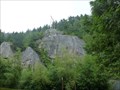 view gallery view galleryN13.2 km |  Murrin Park, Squamish, BC Murrin Park, Squamish, BC
in Established Rock Climbing Areas Number of climbing areas in this small provincial park. posted by: gypsie2 location: British Columbia, Canada date approved: 10/28/2012 last visited: 04/12/2014 |
 view gallery view galleryN13.2 km | Murrin Provincial Park - Squamish, BC in State/Provincial Parks This small wayside park along Highway 99 - The Sea to Sky Highway - has about ten rock faces that a popular rock climbing destinations. For those who do not clambering there are plenty of picnic tables along the shore of Browning Lake. posted by: Dunbar Loop location: British Columbia, Canada date approved: 06/11/2010 last visited: 04/12/2014 |
 view gallery view gallery S14.5 km S14.5 km
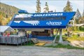
|  Eagle Express Quad Chair - Cypress Mountain - West Vancouver, British Columbia, Canada Eagle Express Quad Chair - Cypress Mountain - West Vancouver, British Columbia, Canada
in Aerial Lifts The Eagle Express Quad is one of several chair lifts at the Cypress Mountain ski area in West Vancouver, British Columbia, Canada. posted by: The A-Team location: British Columbia, Canada date approved: 07/14/2023 last visited: never |
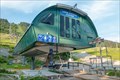 view gallery view galleryS14.5 km | Lions Express Quad Chair - Cypress Mountain - West Vancouver, British Columbia, Canada in Aerial Lifts The Lions Express Quad is one of several chair lifts at the Cypress Mountain ski area in West Vancouver, British Columbia, Canada. posted by: The A-Team location: British Columbia, Canada date approved: 07/16/2023 last visited: never |
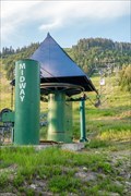 view gallery view galleryS14.6 km | Midway Chair - Cypress Mountain - West Vancouver, British Columbia, Canada in Aerial Lifts The Midway Chair is one of several chair lifts at the Cypress Mountain ski area in West Vancouver, British Columbia, Canada. posted by: The A-Team location: British Columbia, Canada date approved: 07/16/2023 last visited: never |
 view gallery view galleryS14.6 km | Cypress Mountain Olympic Plaza Cam - West Vancouver, British Columbia, Canada in Web Cameras This webcam points toward the Olympic Plaza at Cypress Mountain ski area in West Vancouver, British Columbia, Canada. posted by: The A-Team location: British Columbia, Canada date approved: 07/15/2023 last visited: never |
 view gallery view galleryS14.6 km | Easy Rider Quad Chair - Cypress Mountain - West Vancouver, British Columbia, Canada in Aerial Lifts The Easy Rider Quad is one of several chair lifts at the Cypress Mountain ski area in West Vancouver, British Columbia, Canada. posted by: The A-Team location: British Columbia, Canada date approved: 07/16/2023 last visited: never |
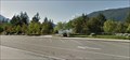
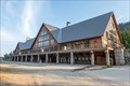 view gallery view galleryS14.6 km |  Cypress Creek Lodge - West Vancouver, British Columbia, Canada Cypress Creek Lodge - West Vancouver, British Columbia, Canada
in Ski Lodges Cypress Creek Lodge is the main lodge for the downhill portion of the Cypress Mountain ski area in West Vancouver, British Columbia, Canada. posted by: The A-Team location: British Columbia, Canada date approved: 07/30/2023 last visited: never |
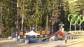
 view gallery view galleryS14.6 km |  Vancouver 2010 - Cypress Mountain Vancouver 2010 - Cypress Mountain
in Modern Olympic Venues This venue held the Freestyle skiing and Snowboard events. It was the most problematic of all the sites for the Vancouver Olympic Committee because of a lack of snow but all events were eventually staged after much work and snow being trucked here. posted by: bcrockcrawler, xstitcher, & BMXer location: British Columbia, Canada date approved: 06/25/2010 last visited: never |
 view gallery view galleryS14.6 km |  Cypress Mountain - West Vancouver, BC Cypress Mountain - West Vancouver, BC
in Winter Sports Locations One of three ski areas within the Metro Vancouver area and the official venue for the Vancouver 2010 Freestyle skiing and Snowboarding events. posted by: bcrockcrawler, xstitcher, & BMXer location: British Columbia, Canada date approved: 06/30/2010 last visited: never |
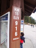 view gallery view galleryS14.6 km |  916 Metres — West Vancouver, BC 916 Metres — West Vancouver, BC
in Elevation Signs Along the Cypress Bowl Road every kilometre is signed with an elevation marker. This one at KM 15 marks the summit of the road at the Cypress Bowl Skiing Complex. posted by: Dunbar Loop location: British Columbia, Canada date approved: 05/02/2010 last visited: never |
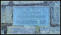
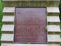
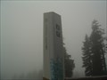
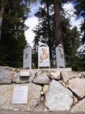 view gallery view galleryS14.6 km |  Cypress Mountain — West Vancouver, BC Cypress Mountain — West Vancouver, BC
in Citizen Memorials In preparation for the 2010 Winter Olympics the Canadian prime minister and the British Columbia premier honoured those people - past, present, and future - who helped developed this winter sports centre on Cypress Mountain. posted by: Dunbar Loop location: British Columbia, Canada date approved: 05/02/2010 last visited: 09/23/2009 |
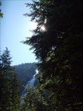
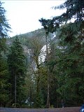 view gallery view galleryN16.3 km |  Shannon Falls, Squamish, B.C. Shannon Falls, Squamish, B.C.
in Waterfalls Shannon Falls is located with easy highway access off of the Sea to Sky Highway (99) near Squamish, B.C.. posted by: Phoneguy Canuck location: British Columbia, Canada date approved: 11/11/2008 last visited: 05/19/2015 |
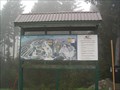
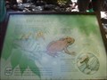 view gallery view galleryN16.3 km |  Tailed Frogs - Shannon Falls, BC Tailed Frogs - Shannon Falls, BC
in Flora and Fauna Information Signs This sign has been slightly vandalized, but is still interesting. posted by: gypsie2 location: British Columbia, Canada date approved: 08/10/2010 last visited: never |
 view gallery view galleryN16.3 km | Shannon Falls Provincial Park - British Columbia in State/Provincial Parks Day use park near Squamish, BC posted by: gypsie2 location: British Columbia, Canada date approved: 08/06/2010 last visited: 08/27/2008 |
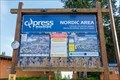 view gallery view galleryS16.6 km |  Cypress Mountain Nordic Area - West Vancouver, British Columbia, Canada Cypress Mountain Nordic Area - West Vancouver, British Columbia, Canada
in Cross Country Ski Trailheads A network of cross country ski trails extends throughout the Nordic area from this point at the Cypress Mountain ski area in West Vancouver, British Columbia, Canada. posted by: The A-Team location: British Columbia, Canada date approved: 07/13/2023 last visited: never |
|