 view gallery view gallery SW3.9 km SW3.9 km
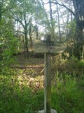
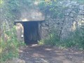
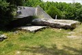
|   Dolmen sous tumulus de Kermarker - Trinité-sur-Mer, France Dolmen sous tumulus de Kermarker - Trinité-sur-Mer, France
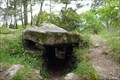
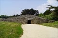
in Megalithic Monuments FR - L'édifice est un dolmen a entrée latérale. Il est composé de deux chambres funéraires.
EN - The building is a dolmen with a side entrance. It is composed of two burial chambers. posted by:  geotrouvtou59 geotrouvtou59 location: Bretagne, France date approved: 05/21/2023 last visited: 05/26/2023 |
 view gallery view gallerySW3.9 km |  Dolmen sous tumulus de Kermarker - Trinité-sur-Mer, France Dolmen sous tumulus de Kermarker - Trinité-sur-Mer, France
in Monuments Historiques Français FR - L'édifice est un dolmen a entrée latérale. Il est composé de deux chambres funéraires.
EN - The building is a dolmen with a side entrance. It is composed of two burial chambers. posted by: geotrouvtou59 location: Bretagne, France date approved: 05/11/2023 last visited: 05/12/2023 |
 view gallery view gallerySW3.9 km |  Dolmen de Kermarquer - La Trinité-sur-Mer, France Dolmen de Kermarquer - La Trinité-sur-Mer, France
in Wikipedia Entries FR - L'édifice est un dolmen a entrée latérale. Il est composé de deux chambres funéraires.
EN - The building is a dolmen with a side entrance. It is composed of two burial chambers. posted by: geotrouvtou59 location: Bretagne, France date approved: 05/11/2023 last visited: 05/12/2023 |
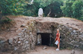
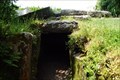
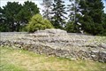
 view gallery view gallerySW3.9 km | Allée couverte dite Er-Roh, La Trinité sur Mer, Bretagne - France in Megalithic Monuments L'allée couverte d'Er-Roh est un dolmen situé à La Trinité-sur-Mer, classée monument historique depuis 1929 / The covered walkway of Er-Roh is a dolmen located in the town of La Trinité-sur-Mer, listed as a historical monument since 1929. posted by: GwenanDu location: Bretagne, France date approved: 07/10/2023 last visited: 07/29/2023 |
 view gallery view gallerySW3.9 km | Allée couverte dite Er-Roh, La Trinité sur Mer, Bretagne - France in Monuments Historiques Français L'allée couverte d'Er-Roh est un dolmen situé à La Trinité-sur-Mer, classée monument historique depuis 1929 / The covered walkway of Er-Roh is a dolmen located in the town of La Trinité-sur-Mer, listed as a historical monument since 1929. posted by: GwenanDu location: Bretagne, France date approved: 07/07/2023 last visited: 07/29/2023 |
 view gallery view gallerySW4 km |  Port de la Trinité sur Mer - Bretagne - France Port de la Trinité sur Mer - Bretagne - France
in Flags of Organizations La drapeau du port de la Trinité sur Mer, dans le Morbihan / The flag of the port of La Trinité sur Mer, in Morbihan posted by: GwenanDu location: Bretagne, France date approved: 07/30/2023 last visited: 03/28/2024 |
 view gallery view gallerySW4 km |  Société Nationale de Sauvetage en Mer, La Trinité sur Mer, France Société Nationale de Sauvetage en Mer, La Trinité sur Mer, France
in Lifeboats and Rescue Stations La SNSM a pour vocation de secourir bénévolement et gratuitement les vies humaines en danger, en mer et sur les côtes / SNSM aims to help voluntary and free human lives in danger at sea and on the coast posted by: GwenanDu location: Bretagne, France date approved: 07/30/2016 last visited: 06/19/2019 |
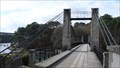 view gallery view gallery NE4.3 km NE4.3 km
|  Le Bono - Pont Suspendu Le Bono - Pont Suspendu
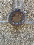
in French Benchmarks Le vieux pont du Bono. posted by:  snoopy_22gl snoopy_22gl location: France date approved: 12/09/2008 last visited: 07/14/2015 |
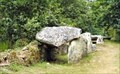
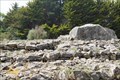
 view gallery view gallerySW4.8 km | Cairn de Kercado - Kerrous, France in Megalithic Monuments One of the oldest dolmens in the region of Carnac is located on a hill posted by: Becktracker location: Bretagne, France date approved: 10/17/2021 last visited: 05/11/2023 |
 view gallery view gallerySW4.8 km | Tumulus-dolmen de Kercado - Carnac, France in Monuments Historiques Français FR - Le cairn de Kercado est un monument mégalithique se trouvant au sud de l'alignement de Kermario.
EN - The cairn of Kercado is a megalithic monument located south of the alignment of Kermario. posted by: geotrouvtou59 location: Bretagne, France date approved: 05/11/2023 last visited: 05/12/2023 |
 view gallery view gallerySW4.8 km | Cairn de Kercado - Carnac, France in Wikipedia Entries FR - Le cairn de Kercado est un monument mégalithique se trouvant au sud de l'alignement de Kermario.
EN - The cairn of Kercado is a megalithic monument located south of the alignment of Kermario. posted by: geotrouvtou59 location: Bretagne, France date approved: 05/11/2023 last visited: 05/12/2023 |
 view gallery view gallery N5.3 km N5.3 km
|  La barque à livres - Port de St Goustan, Auray, France La barque à livres - Port de St Goustan, Auray, France
in Free Community Book Exchanges Boîte à livre en libre service posted by: BCLV4 location: Bretagne, France date approved: 05/17/2019 last visited: 04/16/2019 |
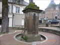
 view gallery view galleryN5.5 km |  Le veilleur de nuit, Auvray, Bretagne, France Le veilleur de nuit, Auvray, Bretagne, France
in Sundials Le veilleur de nuit posted by: BCLV4 location: Nouvelle-Aquitaine, France date approved: 07/17/2019 last visited: 04/16/2019 |
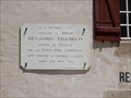 view gallery view galleryN5.5 km |  plaque Benjamin Franklin - Auray,France plaque Benjamin Franklin - Auray,France
in Benjamin Franklin une plaque sur le mur du relais Franklin posted by: sara et gege location: Bretagne, France date approved: 07/28/2016 last visited: 04/16/2019 |
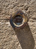 view gallery view galleryN5.5 km | Repère de Nivellement - Hôtel de Ville - Auray, France in French Benchmarks Ce repère cylindrique se trouve sur le soubassement du mur de façade Sud-Est de l'hôtel de ville posted by: LeBourguignon location: Bretagne, France date approved: 06/27/2020 last visited: never |
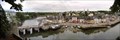 view gallery view galleryN5.6 km |  Saint Goustan - Auray, FRANCE Saint Goustan - Auray, FRANCE
in Stone Bridges Bien qu'existant sûrement déjà auparavant, puisque le pont actuel sur la rivière du Loch date de 1464, c'est vers 1615 que la construction des quais lui donne son aspect actuel.
Although existing surely already before, since the current bridge posted by: bob29 location: France date approved: 06/20/2007 last visited: 06/26/2020 |
 view gallery view galleryN5.6 km | Repère de Nivellement - Chapelle Sainte-Hélène - Auray, France in French Benchmarks Ce repère cylindrique se trouve sur le mur de façade Sud-Ouest du clocher, au Sud-Est de la porte d'entrée de la Chapelle de l'Hôpital posted by: LeBourguignon location: Bretagne, France date approved: 06/27/2020 last visited: never |
 view gallery view gallery NW5.8 km NW5.8 km
|  Pompe à eau- St-Fargeau, Yonne, France Pompe à eau- St-Fargeau, Yonne, France
in Hand Operated Water Pumps Une fontaine à pompe manuelle. Hand Operated Water Pump fountain posted by: gemeloj location: Grand-Est, France date approved: 03/08/2023 last visited: 03/31/2024 |
 view gallery view gallery E6.1 km E6.1 km
| Dolmen de Toulvern in Megalithic Monuments Les dolmens de Toulvern sont situés sur la commune de Baden, Bretagne, France posted by: celene37 location: Bretagne, France date approved: 02/10/2015 last visited: 02/10/2015 |
 view gallery view gallery SE6.1 km SE6.1 km
| Tumulus du Mané-Lud - Locmariaquer, Morbihan, FRA in Megalithic Monuments The Mané-Lud tumulus (or Mane-Lud dolmen) located in the town of Locmariaquer, in the Gulf of Morbihan. posted by: André de Montbard location: Bretagne, France date approved: 11/23/2020 last visited: 09/19/2021 |
 view gallery view gallerySE6.1 km | Tumulus du Mané-Lud - Locmariaquer, France in Monuments Historiques Français Le tumulus du Mané-Lud (ou dolmen de Mane-Lud) situé sur la commune de Locmariaquer, dans le golfe du Morbihan.
-
The Mané-Lud tumulus (or Mane-Lud dolmen) located in the town of Locmariaquer, in the Gulf of Morbihan. posted by: André de Montbard location: Bretagne, France date approved: 11/22/2020 last visited: 09/19/2021 |
 view gallery view gallerySE6.3 km | Tumulus d'Er Grah - Locmariaquer, France in Monuments Historiques Français Le Tumulus d'Er grah est un mégalithe datant du Néolithique, situé sur la commune de Locmariaquer.
-
The Er grah Tumulus is a megalith dating from the Neolithic period, located in the town of Locmariaquer. posted by: André de Montbard location: Bretagne, France date approved: 11/22/2020 last visited: never |
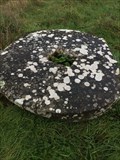 view gallery view galleryNE6.3 km |  Meule de moulin ,Kervilio Bretagne France Meule de moulin ,Kervilio Bretagne France
in Millstones mill wheel posted by: keillec location: Bretagne, France date approved: 03/04/2021 last visited: never |
 view gallery view gallerySE6.3 km | Tumulus d'Er Grah - Locmariaquer, Morbihan, FRA in Megalithic Monuments The Er grah Tumulus is a megalith dating from the Neolithic period, located in the town of Locmariaquer, in the Gulf of Morbihan. posted by: André de Montbard location: Bretagne, France date approved: 11/23/2020 last visited: never |
 view gallery view gallerySE6.4 km | Table des Marchand, Locmariaquer, France in Monuments Historiques Français La Table des Marchand (An Daol Varchant en breton) est un vaste dolmen situé sur le site mégalithique de Locmariaquer.
-
La Table des Marchand (An Daol Varchant in Breton) is a large dolmen located on the megalithic site of Locmariaquer. posted by: André de Montbard location: Bretagne, France date approved: 11/21/2020 last visited: 09/19/2021 |
|