 view gallery view gallery NE3.4 km NE3.4 km
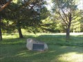
|   Winston-Cadotte Site – La Pointe, WI Winston-Cadotte Site – La Pointe, WI
in U.S. National Register of Historic Places An historical marker is fixed on a rock to mark the site where the Ojibway traded with other natives in the 1600’s. posted by:  wildernessmama wildernessmama location: Wisconsin date approved: 10/17/2013 last visited: never |
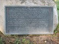 view gallery view galleryNE3.4 km |  Michel Cadotte Marker – La Pointe, WI Michel Cadotte Marker – La Pointe, WI
in Signs of History This historical marker is fixed to a rock at the site of the French trading post on Madeline Island. posted by: wildernessmama location: Wisconsin date approved: 10/16/2013 last visited: never |
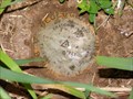
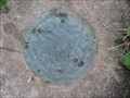 view gallery view gallery W4.5 km W4.5 km
|  NGS Benchmark - Sioux 1978 - Bayfield County, Wisconsin NGS Benchmark - Sioux 1978 - Bayfield County, Wisconsin
in U.S. Benchmarks A NGS horizontal control mark located near historical marker on Highway 13 north of Washburn, Wisconsin. posted by: geegis location: Wisconsin date approved: 06/23/2008 last visited: 10/12/2013 |
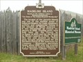
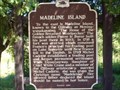 view gallery view galleryW4.5 km |  Madeline Island Madeline Island
in Wisconsin Historical Markers Located at wayside on Hwy 13 north of Washburn. posted by:  Team LightningBugs Team LightningBugs location: Wisconsin date approved: 08/28/2008 last visited: 08/04/2003 |
 view gallery view gallery SW4.7 km SW4.7 km
| Bayfield County, WI - TT 164L in U.S. Benchmarks This benchmark is located off the west side of Highway 13 as you head north of Washburn, Wisconsin. posted by: geegis location: Wisconsin date approved: 07/05/2008 last visited: never |
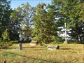 view gallery view galleryNE5 km | La Pointe Indian Cemetery – La Pointe, WI in U.S. National Register of Historic Places An historical sign tells about the La Point Indian Cemetery and the burial traditions of these early natives. posted by: wildernessmama location: Wisconsin date approved: 10/16/2013 last visited: 02/21/2015 |
 view gallery view galleryNE5 km | Marina Site – La Pointe, WI in U.S. National Register of Historic Places The Madeline Island Marina is located at the site of the Ojibway village and cemetery that dates back to the fur trade era of the 18th and 19th centuries. posted by: wildernessmama location: Wisconsin date approved: 10/17/2013 last visited: never |
 view gallery view galleryNE5 km | Site of First Catholic Church – La Pointe, WI in Signs of History This historical plaque marks the spot where the first Catholic church was built on Madeline Island. posted by: wildernessmama location: Wisconsin date approved: 10/16/2013 last visited: 07/19/2014 |
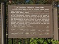 view gallery view galleryNE5 km | La Pointe Indian Cemetery – La Pointe, WI in Signs of History This historical sign tells about the La Point Indian Cemetery and the burial traditions of these early natives. posted by: wildernessmama location: Wisconsin date approved: 10/16/2013 last visited: never |
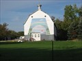 view gallery view gallerySW5.3 km |  Rainbow Barn – rural Washburn, WI Rainbow Barn – rural Washburn, WI
in Murals On one of the most photographed barns in the area, this mural depicts beautiful wonders in the sky. posted by: wildernessmama location: Wisconsin date approved: 10/16/2013 last visited: never |
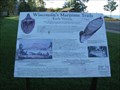 view gallery view galleryNE5.3 km | Early Vessels: Wisconsin's Maritime Trails - La Point, WI in Signs of History This historical marker tells about the history of the birch bark canoe and is located in the city park just south of the downtown area. posted by: wildernessmama location: Wisconsin date approved: 10/14/2013 last visited: never |
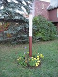 view gallery view galleryNE5.3 km |  St. John’s Church Peace Pole – La Pointe, WI St. John’s Church Peace Pole – La Pointe, WI
in Peace Poles This peace pole stands outside St. John’s Church on Main Street. posted by: wildernessmama location: Wisconsin date approved: 10/14/2013 last visited: never |
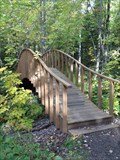 view gallery view gallerySW5.3 km |  Houghton Falls Trail Bridge – Washburn, WI Houghton Falls Trail Bridge – Washburn, WI
in Hiking Path Footbridges This pretty arched bridge is located on the Houghton Trail between the falls and the Lake Superior shoreline posted by: wildernessmama location: Wisconsin date approved: 10/15/2013 last visited: never |
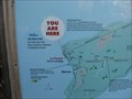 view gallery view galleryNE5.6 km |  You Are Here: Madeline Island - La Pointe, WI You Are Here: Madeline Island - La Pointe, WI
in 'You Are Here' Maps This map shows indicates the roads, bicycle trails, and hiking paths throughout Madeline Island. posted by: wildernessmama location: Wisconsin date approved: 10/14/2013 last visited: never |
 view gallery view gallery N5.6 km N5.6 km
| Madeline Island in Wisconsin Historical Markers At the Madeline Island Historical Museum in La Pointe, WI. posted by: Team LightningBugs location: Wisconsin date approved: 08/28/2008 last visited: 07/19/2022 |
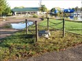
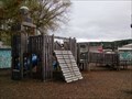 view gallery view galleryN8.4 km |  Playground at East Dock Park - Bayfield WI USA Playground at East Dock Park - Bayfield WI USA
in Public Playgrounds A mostly wooden (old style) playground at a touristy town in Wisconsin posted by: MountainWoods location: Wisconsin date approved: 09/30/2018 last visited: 05/24/2021 |
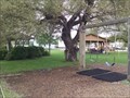 view gallery view galleryN8.4 km |  East Dock Park - Bayfield, WI USA East Dock Park - Bayfield, WI USA
in Municipal Parks and Plazas A small park in a touristy area of Wisconsin posted by: MountainWoods location: Wisconsin date approved: 10/01/2018 last visited: 05/24/2021 |
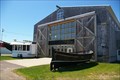 view gallery view galleryN8.4 km |  Bayfield Maritime Museum - Bayfield WI Bayfield Maritime Museum - Bayfield WI
in Maritime Museums Bayfield Maritime Museum - Bayfield WI posted by: kJfishman location: Wisconsin date approved: 03/31/2014 last visited: 05/24/2021 |
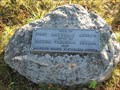
 view gallery view gallerySW8.5 km | Bayfield County Courthouse – Washburn, WI in U.S. National Register of Historic Places A marker is located on the front lawn of the Bayfield Country Courthouse to tell more about the history of this building. posted by: wildernessmama location: Wisconsin date approved: 10/15/2013 last visited: never |
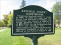 view gallery view gallerySW8.5 km | Bayfield County Courthouse – Washburn, WI in Signs of History This historical marker is located on the front lawn of the Bayfield Country Courthouse. posted by: wildernessmama location: Wisconsin date approved: 10/15/2013 last visited: never |
 SW8.7 km | Wash No 1 - 1953 near Washburn, Wisconsin in U.S. Benchmarks The "Wash No 1 1953" reference mark located on the west side of a cemetery located on the north end of Washburn, Wisconsin. posted by: geegis location: Wisconsin date approved: 07/16/2008 last visited: never |
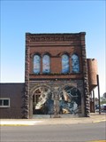 view gallery view gallerySW8.7 km | Vulcan’s Forge – Washburn, WI in Murals This extensive mural is painted on the brick Iron Works building and on the arched window spaces on the second floor. posted by: wildernessmama location: Wisconsin date approved: 10/14/2013 last visited: never |
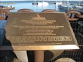 view gallery view galleryN8.7 km |  Memorial to Commercial Fishermen of Bayfield - Bayfield, WI Memorial to Commercial Fishermen of Bayfield - Bayfield, WI
in Maritime Monuments and Memorials This memorial is dedicated to the commercial fisherman of the Bayfield area. posted by: wildernessmama location: Wisconsin date approved: 10/15/2013 last visited: 05/24/2021 |
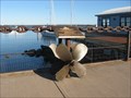 view gallery view galleryN8.7 km |  Outer Island Propeller - Bayfield, WI Outer Island Propeller - Bayfield, WI
in Ship Screws and Aircraft Props Standing at the base of the Commercial Fishermen Memorial plaque are two ship propellers. posted by: wildernessmama location: Wisconsin date approved: 10/15/2013 last visited: 05/24/2021 |
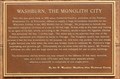 view gallery view gallerySW8.9 km | Washburn, The Monolith City – Washburn, WI in Signs of History This brownstone monolith stands to the right of the historical bank building in downtown Washburn. posted by: wildernessmama location: Wisconsin date approved: 10/13/2013 last visited: 05/21/2021 |
|