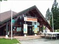
![Image for [EsC] Les marches du Tremplin de Chaux-Neuve](https://img.geocaching.com/waymarking/small/f6fe6a7a-860c-4b40-b818-30c96c33cea7.jpg) view gallery view gallery SE7.1 km SE7.1 km
|   [EsC] Les marches du Tremplin de Chaux-Neuve [EsC] Les marches du Tremplin de Chaux-Neuve
in Outdoor Stairways Si vous souhaitez grimper au sommet de ce tremplin, il vous faudra gravir 698 marches sur un dénivelé de 118 mètres...
Bonne chance à tous ! posted by:  # Wolverine # # Wolverine # location: Bourgogne-Franche-Comté, France date approved: 08/20/2014 last visited: 08/09/2020 |
![Image for [SpT] Le tremplin de Chaux-Neuve](https://img.geocaching.com/waymarking/small/944157e6-70a4-4ed9-b4c0-6ac478d1b05c.jpg) view gallery view gallerySE7.1 km |  [SpT] Le tremplin de Chaux-Neuve [SpT] Le tremplin de Chaux-Neuve
in Ski Jumps La piste de saut à skis de Chaux-Neuve est un magnifique tremplin...
Pour atteindre son sommet, il vous faudra gravir 698 marches !!!
Bonne chance à tous. posted by: # Wolverine # location: Bourgogne-Franche-Comté, France date approved: 02/03/2015 last visited: 08/09/2020 |
 view gallery view gallery E9.8 km E9.8 km
|  ORIGIN - Doubs ORIGIN - Doubs
in River Origins, Destinations and Confluences [FR] Le Doubs est le principal affluent de la Saône et par conséquent un sous-affluent du Rhône. [EN] The Doubs is a 453-kilometre (281 mi) river in far eastern France which strays into western Switzerland. It is a left-bank tributary of the Saône. posted by: RakeInTheCache location: Bourgogne-Franche-Comté, France date approved: 10/08/2021 last visited: never |
 view gallery view gallery W14.5 km W14.5 km
|  Empreintes de dinos- Loulle, Jura, France Empreintes de dinos- Loulle, Jura, France
in Paleontology and Fossils Plusieurs pistes de dinosaures.several dinosaur tracks posted by: gemeloj location: Bourgogne-Franche-Comté, France date approved: 07/28/2019 last visited: 12/08/2019 |
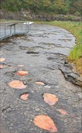 view gallery view galleryW14.5 km |  Empreintes de dinosaures,Loulle, Jura France Empreintes de dinosaures,Loulle, Jura France
in Petrosomatoglyphs Plusieurs pistes de dinosaures.Several dinosaur tracks posted by: gemeloj location: Bourgogne-Franche-Comté, France date approved: 08/15/2019 last visited: 12/08/2019 |
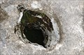 view gallery view galleryW14.6 km |  Lapiaz à Loulle-Jura, France Lapiaz à Loulle-Jura, France
in Natural Sinkholes Belles crevasses naturelles. Beautiful natural sinkholes posted by: gemeloj location: Bourgogne-Franche-Comté, France date approved: 08/05/2019 last visited: 12/09/2019 |
 view gallery view gallery N15 km N15 km
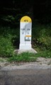
|  Borne séparation département. Boujailles - France Borne séparation département. Boujailles - France
in Milestones [EN]Ancient landmark separation of the departments of Doubs et Jura
[FR]Ancienne borne de séparation des départements du Doubs et du Jura posted by: pmaupin location: Bourgogne-Franche-Comté, France date approved: 08/07/2016 last visited: 07/24/2016 |
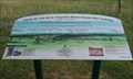 view gallery view galleryN19.3 km |  Table d'orientation de La Chapelle Notre-Dame des Champs - Boujailles - France Table d'orientation de La Chapelle Notre-Dame des Champs - Boujailles - France
in Orientation Tables [EN] Orientation table on the hill overlooking Boujailles before a small chapel.
[FR] Table d'orientation sur la colline qui domine Boujailles, devant une petite chapelle. posted by: pmaupin location: Bourgogne-Franche-Comté, France date approved: 08/29/2016 last visited: 07/26/2016 |
 view gallery view galleryE20.3 km | ") Grottes de Vallorbe - Vallorbe, Jura-Nord vaudois, Waadt, CH Grottes de Vallorbe - Vallorbe, Jura-Nord vaudois, Waadt, CH
in Cave Entrances (Natural) Les Grottes de Vallorbe - Die Grotten von Vallorbe. posted by:  Tharandter Tharandter location: Vaud, Switzerland date approved: 02/14/2013 last visited: never |
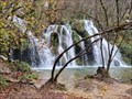
 view gallery view gallery SW21.1 km SW21.1 km
|  Hérisson (rivière) - Menetrux en Joux, France Hérisson (rivière) - Menetrux en Joux, France
in Wikipedia Entries FR - Le Hérisson (le torrent aux trente et une cascades)
EN - The Hedgehog (the torrent with thirty-one waterfalls) posted by: geotrouvtou59 location: Bourgogne-Franche-Comté, France date approved: 04/17/2021 last visited: 04/24/2008 |
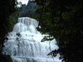 view gallery view gallerySW21.1 km |  Cascade Hérisson - Menetrux en Joux, France Cascade Hérisson - Menetrux en Joux, France
in Waterfalls FR - Le Hérisson (le torrent aux trente et une cascades)
EN - The Hedgehog (the torrent with thirty-one waterfalls) posted by: geotrouvtou59 location: Bourgogne-Franche-Comté, France date approved: 04/17/2021 last visited: 04/17/2008 |
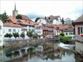 view gallery view galleryE22.7 km |  Tourist Information Vallorbe, Switzerland Tourist Information Vallorbe, Switzerland
in Tourist Information Centers - Visitor Centers Official tourist office for the city of Vallorbe. posted by: tijgetje location: Vaud, Switzerland date approved: 08/31/2009 last visited: never |
 view gallery view gallery S26.7 km S26.7 km
| Tourist Information Les Rousses, France in Tourist Information Centers - Visitor Centers Official Information point for the region around Les Rousses.
Famous in Winter posted by: tijgetje location: Bourgogne-Franche-Comté, France date approved: 08/31/2009 last visited: 10/02/2020 |
 view gallery view gallery NW26.9 km NW26.9 km
| Cascade des Tufs - Les Planches-près-Arbois (Jura), France in Waterfalls [FR] La cascade des Tufs est une chute d'eau de la Cuisance située au fond de la réculée des Planches, près d'Arbois. [EN] The "Cascade des Tufs" is a waterfall formed by the river Cuisance at the bottom of the "reculée des Planches" near Arbois. posted by: Delgrafo location: Bourgogne-Franche-Comté, France date approved: 01/24/2023 last visited: 01/24/2023 |
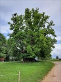 view gallery view galleryNW27.2 km |  Le tilleul de Grange Sauvaget - Bracon (Jura), France Le tilleul de Grange Sauvaget - Bracon (Jura), France
in Exceptional Trees [FR] Ce Tilia platyphyllos aurait été planté en 1477 en commémoration du mariage de la fille de Charles le Téméraire. [EN] This linden tree is said to have been planted in 1477 commemorating the mariage of the daughter of Charles the Bold. posted by: RakeInTheCache location: Bourgogne-Franche-Comté, France date approved: 10/02/2021 last visited: never |
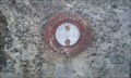 view gallery view galleryNW27.4 km |  Benchmark - Pont des Carmes à Bracon Benchmark - Pont des Carmes à Bracon
in French Benchmarks Repère Cylindrique du Nivellement Général posted by: pmaupin location: Bourgogne-Franche-Comté, France date approved: 08/02/2016 last visited: 07/29/2016 |
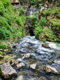
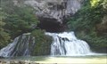 view gallery view galleryN27.5 km | ORIGIN - Le Lison - Nans sous Sainte-Anne, France in River Origins, Destinations and Confluences [EN] The source site of the Lison consists of three geological curiosities: the source, the pit of the Creux-Billard and the cave Sarrasine.
[FR] Le site de la source du Lison se compose de trois curiosités géologiques. posted by: pmaupin location: Bourgogne-Franche-Comté, France date approved: 06/28/2017 last visited: 01/23/2023 |
 view gallery view galleryN27.5 km | Source du Lison - Nans sous Sainte-Anne, France in Waterfalls [EN] The source site of the Lison consists of three geological curiosities: the source, the pit of the Creux-Billard and the cave Sarrasine.
[FR] Le site de la source du Lison se compose de trois curiosités géologiques. posted by: pmaupin location: Bourgogne-Franche-Comté, France date approved: 03/18/2017 last visited: 01/23/2023 |
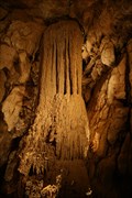
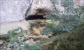 view gallery view galleryN27.7 km | La grotte Sarrazine - Nans-sous-Saint-Anne, France in Cave Entrances (Natural) [EN] The Sarrazine cave, also known as "Saint-Christophe's mantle", is located near Nans-sous-Saint-Anne in the Doubs.
[FR] La grotte Sarrazine, appelée aussi « manteau de Saint-Christophe » se situe près de Nans-sous-Saint-Anne dans le Doubs. posted by: pmaupin location: Bourgogne-Franche-Comté, France date approved: 03/18/2017 last visited: 01/23/2023 |
![Image for [ChX] Le château de Joux](https://img.geocaching.com/waymarking/small/923fe2bb-3491-4300-ae78-2c6c6d06386f.jpg) view gallery view gallery NE27.8 km NE27.8 km
|  [ChX] Le château de Joux [ChX] Le château de Joux
in Castles Le château de Joux, situé en plein coeur du Haut-Jura, surplombe toute la vallée...
Entièrement restauré, il a été la prison du célèbre Mirabeau mais aussi de Toussaint Louverture, figure noire à l'origine de la lutte contre l'esclavage... posted by: # Wolverine # location: Bourgogne-Franche-Comté, France date approved: 02/03/2015 last visited: 09/01/2022 |
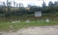 view gallery view galleryNW27.8 km |  Etang des chevres - Clucy - Jura, France Etang des chevres - Clucy - Jura, France
in Fishing Holes [EN] Small farming village, Clucy shelters the pond of the goats, small corner of paradise, in peace.
[FR] Petit village agricole, Clucy abrite l'étang des chêvres, petit coin de paradis, au calme. posted by: pmaupin location: Bourgogne-Franche-Comté, France date approved: 01/25/2017 last visited: 01/25/2017 |
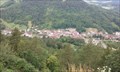 view gallery view galleryNW28.2 km |  Panorama de Fort-Belin - Salins-les-bains - Jura, France Panorama de Fort-Belin - Salins-les-bains - Jura, France
in Scenic Overlooks [EN] This panoramic view is located on the heights of Fort-Belin which overlooks the valley of Salins-les-Bains.
[FR] Cette vue panoramique est située sur les hauteurs du Fort-Belin qui domine la vallée de Salins-les-bains. posted by: pmaupin location: Bourgogne-Franche-Comté, France date approved: 01/25/2017 last visited: 08/14/2022 |
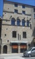 view gallery view galleryNW28.3 km |  Maison-Forte - Salins-les-bains - Jura - France Maison-Forte - Salins-les-bains - Jura - France
in Monuments Historiques Français [FR] Maison Forte du XIIIème siècle, construite par la Famille De Chalon.
[EN] House Forte of the XIIIth century, built by the Family of Chalon. posted by: pmaupin location: Bourgogne-Franche-Comté, France date approved: 12/24/2016 last visited: 07/29/2016 |
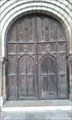 view gallery view galleryNW28.3 km |  Collégiale Saint-Anatoile, Salins les Bains, Jura, France Collégiale Saint-Anatoile, Salins les Bains, Jura, France
in Doorways of the World [EN] Gateway to the Collegiate Saint Anatoile on the heights of the city of Salins-les-Bains
[FR]Porte d'entrée de la Collégiale Saint Anatoile, sur les hauteurs de la Ville de Salins les Bains posted by: pmaupin location: Bourgogne-Franche-Comté, France date approved: 08/21/2016 last visited: 08/14/2022 |
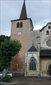 view gallery view galleryNW28.3 km |  L'Église Saint-Anatoile - Salins-les-Bains, France L'Église Saint-Anatoile - Salins-les-Bains, France
in Roman Catholic Churches [EN] The church Saint-Anatoile is a Catholic church of the XIIIth century of Gothic style Burgundy FR] L'église Saint-Anatoile est une église catholique du XIIIe siècle de style gothique bourguignon. posted by: pmaupin location: Bourgogne-Franche-Comté, France date approved: 11/08/2017 last visited: 08/14/2022 |
|