 view gallery view gallery NW21.9 km NW21.9 km
|   McDonald's MABLY on N7 McDonald's MABLY on N7
in McDonald's Restaurants on the N7, at the entrance of agglomeration of Roannes posted by:  JMRetSB JMRetSB location: Auvergne-Rhône-Alpes, France date approved: 08/24/2012 last visited: 08/19/2012 |
 view gallery view gallery N25.7 km N25.7 km
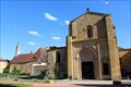
|  Abbaye de Charlieu - Charlieu, France Abbaye de Charlieu - Charlieu, France
in Abbeys, Convents and Monasteries [EN] The Abbey of Charlieu is located 20 km from Roanne, on the border of Burgundy, its name comes from "Cher Lieu". [FR] L'Abbaye de Charlieu est située à 20 km de Roanne, à la limite de la Bourgogne, son nom vient de "Cher Lieu". posted by: pmaupin location: Auvergne-Rhône-Alpes, France date approved: 08/05/2017 last visited: 07/10/2017 |
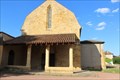
 view gallery view galleryN25.7 km |  Abbaye Saint-Fortuné - Charlieu, France Abbaye Saint-Fortuné - Charlieu, France
in Wikipedia Entries [EN] The Abbey of Charlieu is located 20 km from Roanne, on the border of Burgundy, its name comes from "Cher Lieu".
[FR] L'Abbaye de Charlieu est située à 20 km de Roanne, à la limite de la Bourgogne, son nom vient de "Cher Lieu". posted by: pmaupin location: Auvergne-Rhône-Alpes, France date approved: 07/07/2017 last visited: 07/05/2017 |
 view gallery view galleryN25.7 km |  Abbaye Saint-Fortuné - Charlieu, France Abbaye Saint-Fortuné - Charlieu, France
in Monuments Historiques Français [FR] L'Abbaye de Charlieu est située à 20 km de Roanne, à la limite de la Bourgogne, son nom vient de "Cher Lieu".
[EN] The Abbey of Charlieu is located 20 km from Roanne, on the border of Burgundy, its name comes from "Cher Lieu". posted by: pmaupin location: Auvergne-Rhône-Alpes, France date approved: 08/05/2017 last visited: 07/10/2017 |
 view gallery view galleryN25.9 km | Couvent des Cordeliers - Saint-Nizier-sous-Charlieu, France in Monuments Historiques Français [FR] Fondé vers 1280 par une communauté de frères franciscains, le couvent connaît une histoire mouvementée.
[EN] Founded around 1280 by a community of Franciscan friars, the convent has a turbulent history. posted by: pmaupin location: Auvergne-Rhône-Alpes, France date approved: 07/11/2017 last visited: 07/05/2017 |
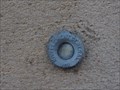 view gallery view galleryNW26.1 km |  Benchmark - Church of Pouilly sous Charlieu Benchmark - Church of Pouilly sous Charlieu
in French Benchmarks Benchmark at the church of Pouilly sous Charlieu - Höhenfestpunkt an der Kirche von Pouilly sous Charlieu posted by: Windego1 location: Auvergne-Rhône-Alpes, France date approved: 06/22/2014 last visited: 07/09/2017 |
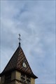 view gallery view galleryNW27.4 km | Benchmark - Point Géodésique - Église Saint-Irénée - Briennon, France in French Benchmarks Repère géodésique du point 1, au sommet du clocher, sur l'axe et au centre de la croix, avec un Azimut de la prise de vue égal à 150 gr. posted by: pmaupin location: Auvergne-Rhône-Alpes, France date approved: 08/05/2017 last visited: 07/10/2017 |
 view gallery view galleryNW27.4 km | Benchmark - Église Saint Irénée - Briennon, France in French Benchmarks Le Repère Cylindrique du Nivellement Général se situe sur le soubassement de l'about du contrefort de l'église côté "St Germain, face à la route. posted by: pmaupin location: Auvergne-Rhône-Alpes, France date approved: 08/05/2017 last visited: 07/10/2017 |
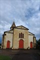
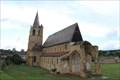
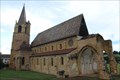
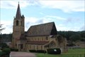
 view gallery view galleryNW27.4 km | Église Saint Irénée - Briennon, France in Monuments Historiques Français [FR] L'église comporte un vaisseau moderne et un chœur ancien, daté de la fin du XIe ou du début du XIIe siècle.
[EN] The church contains a modern vessel and an ancient choir, dating from the end of the 11th or the beginning of the 12th century. posted by: pmaupin location: Auvergne-Rhône-Alpes, France date approved: 08/05/2017 last visited: 07/10/2017 |
 view gallery view galleryNW27.4 km |  Église Saint Irénée - Briennon, France Église Saint Irénée - Briennon, France
in Roman Catholic Churches [EN] The church contains a modern vessel and an ancient choir, dating from the end of the 11th or the beginning of the 12th century.
[FR] L'église comporte un vaisseau moderne et un chœur ancien, daté de la fin du XIe ou du début du XIIe siècle. posted by: pmaupin location: Auvergne-Rhône-Alpes, France date approved: 01/23/2018 last visited: 07/10/2017 |
 view gallery view galleryNW27.4 km |  Église Saint Irénée - Briennon, France Église Saint Irénée - Briennon, France
in Medieval Churches [EN] The church contains a modern vessel and an ancient choir, dating from the end of the 11th or the beginning of the 12th century. [FR] L'église comporte un vaisseau moderne et un chœur ancien, daté de la fin du XIe ou du début du XIIe siècle. posted by: pmaupin location: Centre-Val-de-Loire, France date approved: 01/23/2018 last visited: 07/10/2017 |
 view gallery view galleryNW27.4 km | Église Saint Irénée - Briennon, France in This Old Church [EN] The church contains a modern vessel and an ancient choir, dating from the end of the 11th or the beginning of the 12th century. [FR] L'église comporte un vaisseau moderne et un chœur ancien, daté de la fin du XIe ou du début du XIIe siècle. posted by: pmaupin location: Auvergne-Rhône-Alpes, France date approved: 01/23/2018 last visited: 07/10/2017 |
 view gallery view gallery E27.8 km E27.8 km
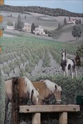
|  Les chevaux - Chessy les mines - Rhône Les chevaux - Chessy les mines - Rhône
in Murals mural in the land of golden stone
fresque murale au pays des pierres dorées posted by: JMRetSB location: Auvergne-Rhône-Alpes, France date approved: 10/15/2013 last visited: 10/05/2013 |
 view gallery view galleryNW29.5 km |  Le Chemin de Cluny - De Charlieu à Montbrison - La Bénisson-Dieu, France Le Chemin de Cluny - De Charlieu à Montbrison - La Bénisson-Dieu, France
in Way of St. James [EN] The former abbey of Notre-Dame-de-la-Blessing-of-God on the way to Cluny, part of the road to Saint-Jacques.
[FR] L’ancienne abbaye de Notre-Dame-de-la-Bénédiction-de-Dieu sur le chemin de Cluny, partie du chemin de Saint-Jacques. posted by: pmaupin location: Auvergne-Rhône-Alpes, France date approved: 01/24/2018 last visited: 01/23/2018 |
 view gallery view galleryNW29.5 km | Abbaye de la Bénisson-Dieu - La Bénisson-Dieu, France in Abbeys, Convents and Monasteries [EN] The former abbey of Notre-Dame-de-la-Bénédiction-de-Dieu was a Cistercian settlement in Benedictine land.
[FR] L’ancienne abbaye de Notre-Dame-de-la-Bénédiction-de-Dieu était une implantation cistercienne en terre bénédictine. posted by: pmaupin location: Auvergne-Rhône-Alpes, France date approved: 07/18/2017 last visited: 07/10/2017 |
 view gallery view galleryNW29.5 km | Eglise Notre-Dame-et-Saint-Bernard - La Bénisson-Dieu, France in Medieval Churches [EN] Church of the former abbey of Our Lady of the Blessing of God, Cistercian settlement in Benedictine land. [FR] Eglise de l’ancienne abbaye de Notre-Dame-de-la-Bénédiction-de-Dieu, implantation cistercienne en terre bénédictine. posted by: pmaupin location: Auvergne-Rhône-Alpes, France date approved: 01/23/2018 last visited: 07/10/2017 |
 view gallery view galleryNW29.5 km | Abbaye de la Bénisson-Dieu - La Bénisson-Dieu, France in Wikipedia Entries [EN] The former abbey of Notre-Dame-de-la-Bénédiction-de-Dieu was a Cistercian settlement in Benedictine land.
[FR] L’ancienne abbaye de Notre-Dame-de-la-Bénédiction-de-Dieu était une implantation cistercienne en terre bénédictine. posted by: pmaupin location: Auvergne-Rhône-Alpes, France date approved: 07/10/2017 last visited: 07/10/2017 |
 view gallery view galleryNW29.5 km | Eglise Notre-Dame-et-Saint-Bernard - La Bénisson-Dieu, France in This Old Church [EN] Church of the former abbey of Our Lady of the Blessing of God, Cistercian settlement in Benedictine land.
[FR] Eglise de l’ancienne abbaye de Notre-Dame-de-la-Bénédiction-de-Dieu, implantation cistercienne en terre bénédictine. posted by: pmaupin location: Auvergne-Rhône-Alpes, France date approved: 01/23/2018 last visited: 07/10/2017 |
 view gallery view galleryNW29.5 km | Eglise Notre-Dame-et-Saint-Bernard - La Bénisson-Dieu, France in Roman Catholic Churches [EN] Church of the former abbey of Our Lady of the Blessing of God, Cistercian settlement in Benedictine land. [FR] Eglise de l’ancienne abbaye de Notre-Dame-de-la-Bénédiction-de-Dieu, implantation cistercienne en terre bénédictine. posted by: pmaupin location: Auvergne-Rhône-Alpes, France date approved: 01/23/2018 last visited: 07/10/2017 |
 view gallery view galleryNW29.5 km | Abbaye de la Bénisson-Dieu - La Bénisson-Dieu, France in Monuments Historiques Français [FR] L’ancienne abbaye de Notre-Dame-de-la-Bénédiction-de-Dieu était une implantation cistercienne en terre bénédictine.
[EN] The former abbey of Notre-Dame-de-la-Bénédiction-de-Dieu was a Cistercian settlement in Benedictine land. posted by: pmaupin location: Auvergne-Rhône-Alpes, France date approved: 07/13/2017 last visited: 07/11/2017 |
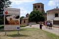
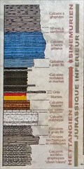 view gallery view galleryE32 km |  Pierres folles - 201Ma to 190Ma - Saint-Jean-des-Vignes - France Pierres folles - 201Ma to 190Ma - Saint-Jean-des-Vignes - France
in Timelines 10 Ma reveal themselves. The fault of crazy stones is the result of a field movement due to the formation of the Alps /\ 10 Ma se révèlent. La faille de pierres-folles est le resultat d'un mouvement de terrain du à la formation des Alpes. posted by: JMRetSB location: Bourgogne-Franche-Comté, France date approved: 05/23/2017 last visited: 02/13/2020 |
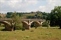 view gallery view galleryNW33.2 km |  Le Pont d'Iguerande, Bourgogne du Sud, France Le Pont d'Iguerande, Bourgogne du Sud, France
in Arch Bridges A stone brigde across the River Loire, at Iguerande, Brionnais, Département Saône-et-Loire (71), Bourgogne du Sud, France. posted by:  Dirkjogt Dirkjogt location: Bourgogne-Franche-Comté, France date approved: 07/10/2011 last visited: 06/09/2014 |
 view gallery view galleryNW33.2 km |  Le Pont d'Iguerande, Bourgogne du Sud, France Le Pont d'Iguerande, Bourgogne du Sud, France
in Stone Bridges A stone bridge across the River Loire, at Iguerande, Brionnais, Département Saône-et-Loire (71), Bourgogne du Sud, France. posted by: Dirkjogt location: Bourgogne-Franche-Comté, France date approved: 07/08/2011 last visited: 06/09/2014 |
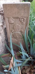 view gallery view galleryE33.2 km |  Borne de la Dîmerie - Limas , France Borne de la Dîmerie - Limas , France
in European Historic Survey Stones, Monuments and Benchmarks Cette borne se situe dans la commune de Limas. Elle représente un témoin de l'Histoire.
This terminal is located in the municipality of Limas. It represents a witness of history. posted by: Georgioturino location: Auvergne-Rhône-Alpes, France date approved: 03/16/2023 last visited: never |
 view gallery view galleryNW33.6 km | Iguerande, Bourgogne, France in Wikipedia Entries Village in the South of the Bourgogne region, France posted by: Dirkjogt location: Bourgogne-Franche-Comté, France date approved: 07/09/2011 last visited: 06/08/2014 |
|