 view gallery view gallery SE34.3 km SE34.3 km
|   Challis, Idaho 83226 Challis, Idaho 83226
in U.S. Post Offices The Challis, Idaho Post Office. posted by:  Volcanoguy Volcanoguy location: Idaho date approved: 11/21/2010 last visited: 09/11/2016 |
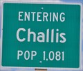 view gallery view gallerySE35.6 km |  Challis, Idaho ~ Population 1081 Challis, Idaho ~ Population 1081
in Population Signs This Population Sign is on the east side of US Highway 93 at the southern city limits of Challis, Idaho. posted by: brwhiz location: Idaho date approved: 12/22/2012 last visited: 06/02/2016 |
 view gallery view gallery S36.4 km S36.4 km
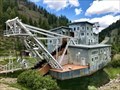
|  Yankee Fork Gold Dredge - Bonanza, Idaho, USA Yankee Fork Gold Dredge - Bonanza, Idaho, USA
in Preserved Machines on Public Display The Yankee Fork Gold Dredge is a well-preserved gold dredge in Central Idaho that is open to the public for tours (admission price for the tour is $5 per person) from the Saturday before Memorial Day to Labor Day. posted by: Tom.dog location: Idaho date approved: 07/31/2022 last visited: never |
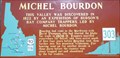 view gallery view gallerySE36.5 km |  #303 - Michel Bourdon #303 - Michel Bourdon
in Idaho Historical Markers Idaho History Sign #303 about Michel Bourdon. posted by: Volcanoguy location: Idaho date approved: 08/06/2011 last visited: 09/14/2016 |
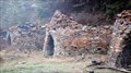 view gallery view gallerySE38.6 km |  Ramshorn Mine charcoal kilns Ramshorn Mine charcoal kilns
in Ovens and Kilns Kilns used by the Ramshorn Mine. posted by: muddawber location: Idaho date approved: 09/05/2008 last visited: never |
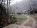
 view gallery view gallerySE38.6 km |  Ramshorn Mine Ramshorn Mine
in Mines An abandoned mine where you can still view most of the still standing buildings of the town of Bayhorse. posted by: muddawber location: Idaho date approved: 09/05/2008 last visited: 06/02/2016 |
 view gallery view gallerySE38.8 km |  Bayhorse, Idaho Bayhorse, Idaho
in Ghost Towns A town that peaked at 300 people. posted by: muddawber location: Idaho date approved: 09/05/2008 last visited: never |
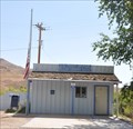 view gallery view gallery E42.2 km E42.2 km
| Ellis, Idaho 83235 in U.S. Post Offices This Post Office is located at 26375 Highway 93 in Ellis, Idaho. posted by: brwhiz location: Idaho date approved: 01/29/2013 last visited: 09/11/2016 |
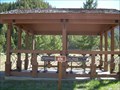 view gallery view galleryS48.1 km | Sunbeam Dam #656 in Idaho Historical Markers Although no familiar Historical sign is at this location, the shelter protects several interpretive signs describing the small earthen dam that is still partially visible below the overlook. posted by: Touchstone location: Idaho date approved: 06/25/2007 last visited: 06/03/2016 |
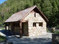 view gallery view galleryS48.4 km |  Sunbeam Bath House - Sunbeam Idaho Sunbeam Bath House - Sunbeam Idaho
in Civilian Conservation Corps The 1937 stonework building at this site, remains as a tribute to the Civilian Conservation Corp craftsmanship. CCC workers from Camp Clayton built this structure. It was originally used as a bathhouse, but is now an historic site. posted by: Touchstone location: Idaho date approved: 06/25/2007 last visited: 08/28/2016 |
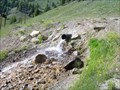 view gallery view galleryS48.8 km |  Sunbeam Hot Springs Sunbeam Hot Springs
in Hot Springs Adjacent to the highway, perhaps not the most scenic hot springs, but access is easy and there is ample parking at the nearby historical CCC bath house. posted by: Touchstone location: Idaho date approved: 06/25/2007 last visited: 09/03/2016 |
 view gallery view gallery SW57.5 km SW57.5 km
|  Population Center of Idaho Witness Monument Population Center of Idaho Witness Monument
in U.S. Historic Survey Stones and Monuments Located a few miles from the town of Stanley, Idaho, this Monument offers a nice view of the nearby Sawtooth Mountains and a break for the weary driver. posted by: Touchstone location: Idaho date approved: 06/26/2007 last visited: never |
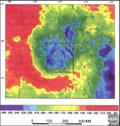 view gallery view gallerySE57.5 km |  Beaverhead Crater, Idaho Beaverhead Crater, Idaho
in Impact Craters Beaverhead Crater is an impact structure located in central Idaho around the Challis area. posted by: Rose Red location: Idaho date approved: 07/21/2007 last visited: never |
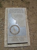
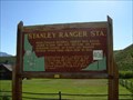 view gallery view gallerySW58.4 km | Stanley Ranger Station #406 in Idaho Historical Markers When Challis National Forest was established in 1908, the site near this marker became an administrative center. An early Log Ranger Station stood at this site from 1909 to 1932. posted by: Touchstone location: Idaho date approved: 06/25/2007 last visited: 06/03/2016 |
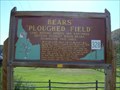 view gallery view gallerySW58.4 km | Bears' Ploughed Field #328 in Idaho Historical Markers Long before miners and ranchers settled Stanley Basin, bears dominated this area. posted by: Touchstone location: Idaho date approved: 06/25/2007 last visited: 06/03/2016 |
 view gallery view gallery NE60.8 km NE60.8 km
|  45th Parallel Sign ~ Salmon, Idaho 45th Parallel Sign ~ Salmon, Idaho
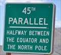
in Great Lines of Earth This sign marks the 45th Parallel, halfway between the Equator and the North Pole. It is about 12 miles south of Salmon, Idaho on US Highway 93. posted by: brwhiz location: Idaho date approved: 12/21/2012 last visited: never |
 view gallery view gallerySW61.6 km |  Stanley Lake - Custer County, ID Stanley Lake - Custer County, ID
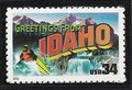
in Philatelic Photographs Beautiful Stanley Lake forms the backdrop of this 2002 U.S. postage stamp meant to resemble a vintage postcard. posted by: hykesj location: Idaho date approved: 11/05/2022 last visited: never |
 view gallery view gallerySW63.2 km | McGowan Peak - Custer County, ID in Philatelic Photographs A mountain bluebird and McGowan Peak in the Sawtooth Range adorn this 1990 U.S. postage stamp commemorating Idaho’s 100th anniversary. posted by: hykesj location: Idaho date approved: 10/01/2022 last visited: never |
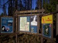 view gallery view gallerySW65.8 km |  Redfish Lake Trailhead Redfish Lake Trailhead
in Trail Registers This is the trailhead at redfish lake about a .25 mile form the Redfish Lodge. posted by: AA&C location: Idaho date approved: 10/13/2007 last visited: 06/03/2016 |
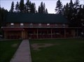 view gallery view gallerySW66.5 km |  Redfish Lodge Idaho Redfish Lodge Idaho
in Lodge-Style Accommodations Redfish Lodge on the shore of Redfish lake in Idaho posted by: AA&C location: Idaho date approved: 08/27/2007 last visited: 02/16/2021 |
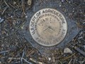 view gallery view gallerySW66.9 km |  U.S. Dept of Agriculture Forest Service Point U.S. Dept of Agriculture Forest Service Point
in U.S. Benchmarks Found on a short path between the Point Camp Ground and the coast of Redfish Lake. posted by:  Cache Comandos Cache Comandos location: Idaho date approved: 08/17/2008 last visited: never |
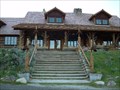 view gallery view galleryS68.4 km |  Idaho Rocky Mountain Club - Stanley, ID Idaho Rocky Mountain Club - Stanley, ID
in U.S. National Register of Historic Places This is one of those historic locations that I love: not a dusty old building that has some remote relevance to the present, but a piece of living history that has relevance to present day travelers as it did nearly 80 years ago. posted by: Touchstone location: Idaho date approved: 06/24/2007 last visited: never |
 view gallery view galleryS68.7 km | Idaho Rocky Mountain Ranch Hot Springs in Hot Springs A private hot spring fed pool associated with the nearby Idaho Rocky Mountain Ranch. posted by: Touchstone location: Idaho date approved: 06/25/2007 last visited: never |
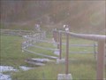
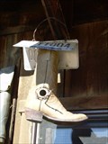 view gallery view galleryS68.7 km |  The Boot-house The Boot-house
in Unique Bird Houses Located near the barn of the Idaho Rocky Mountain Ranch, this cowboy boot appears to have found a second life after, what I can imagine, a life full of adventure on some wranglers foot. posted by: Touchstone location: Idaho date approved: 06/25/2007 last visited: never |
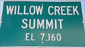 view gallery view gallerySE70.2 km |  7160 Ft - Willow Creek Summit - Idaho 7160 Ft - Willow Creek Summit - Idaho
in Elevation Signs Elevation sign at Willow Creek Summit. posted by: Volcanoguy location: Idaho date approved: 07/26/2011 last visited: 09/24/2010 |
|