 view gallery view gallery SE4.2 km SE4.2 km
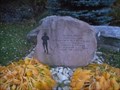
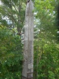
|   Terry Fox - Kaladar, ON Terry Fox - Kaladar, ON
in Citizen Memorials Simple monument to Terry Fox, whose Marathon of Hope in 1980 inspired a country. posted by:  jiggs11 jiggs11 location: Ontario, Canada date approved: 05/29/2016 last visited: 05/30/2016 |
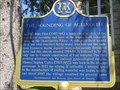
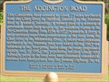 view gallery view gallerySE4.2 km |  "THE ADDINGTON ROAD" -- Kaladar "THE ADDINGTON ROAD" -- Kaladar
in Ontario Provincial Plaques Found in Kaladar Picnic Park, on the south side of Highway 7. posted by:  Timo Explorer Timo Explorer location: Ontario, Canada date approved: 05/31/2010 last visited: 08/12/2020 |
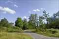 view gallery view gallery E8.5 km E8.5 km
|  Camp K12R - Arden, Ontario Camp K12R - Arden, Ontario
in Free Campsites This is a free campsite in Arden, Ontario. posted by: InGodsHands location: Ontario, Canada date approved: 04/24/2012 last visited: 08/31/2021 |
 view gallery view gallery NW9 km NW9 km
|  Elzevir Peatlands Conservation Reserve - Addington Highlands, Ontario Elzevir Peatlands Conservation Reserve - Addington Highlands, Ontario
in Public Access Lands One of the largest mostly continuous peatlands in southern Ontario, this area has a collection of low ridges that poke through a flat wetland system along the Canadian Shield. posted by: Trail Blaisers location: Ontario, Canada date approved: 03/15/2018 last visited: never |
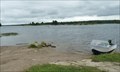
 view gallery view galleryNW9.2 km |  Deerrock Lake - Addington Highlands, Ontario Deerrock Lake - Addington Highlands, Ontario
in Natural Lakes Deerrock Lake is a semi-remote lake in Ontario's Canadian Shield. It is about 6 km east-west and 1.5 km north-south. posted by: Trail Blaisers location: Ontario, Canada date approved: 03/16/2018 last visited: never |
 view gallery view gallery S12.4 km S12.4 km
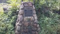
|  Sheffield Conservation Area Cairn, Ontario, Canada Sheffield Conservation Area Cairn, Ontario, Canada
in Cairns A Cairn commemorating the establishment of the Sheffield Conservation Area. posted by: The Burrow location: Ontario, Canada date approved: 09/03/2017 last visited: 10/13/2015 |
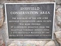 view gallery view galleryS12.4 km |  Sheffield Conservation Area - Kaladar, ON Sheffield Conservation Area - Kaladar, ON
in Community Commemoration Marker affixed to a cairn at the entrance to Sheffield Conservation area commemorating the donation of the land for the Conservation Area in 1975. posted by: jiggs11 location: Ontario, Canada date approved: 07/22/2018 last visited: never |
 view gallery view galleryS12.4 km | Sheffield Conservation Area - Erinsville, Ontario in Public Access Lands A beautifully rugged place to hike through the southern reaches of the Canadian Shield. Many small lakes also make it a nice spot for a paddle with kayak or canoe. It's also a designated dark sky reserve for astronomers. posted by: Trail Blaisers location: Ontario, Canada date approved: 09/22/2016 last visited: never |
 view gallery view galleryS12.6 km |  Mellon House Chimney - Erinsville, Ontario Mellon House Chimney - Erinsville, Ontario
in Lonely Chimneys Lonely chimney located just west of County Road 41 north of Erinsville, Ontario. posted by: mTn_biKer65 location: Ontario, Canada date approved: 11/20/2012 last visited: 08/20/2023 |
 view gallery view galleryS12.6 km |  Guest Book - L&A Dark Skies Viewing Area - Erinsville, ON Guest Book - L&A Dark Skies Viewing Area - Erinsville, ON
in Guest Books New Guest Book for the Lennox and Addington County Dark Skies Viewing Area near Erinsville, ON.l posted by: jiggs11 location: Ontario, Canada date approved: 06/13/2023 last visited: never |
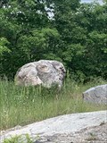 view gallery view galleryS12.6 km |  ET - Sheffield Conservation Area - Erinsville, ON ET - Sheffield Conservation Area - Erinsville, ON
in Simulacra Large erratic that is hiding ET, located in the Sheffield Conservation Area, not far from the Dark Skies Viewing Area. posted by: jiggs11 location: Ontario, Canada date approved: 07/15/2023 last visited: never |
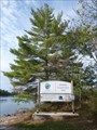
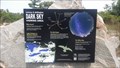 view gallery view galleryS12.6 km |  L&A County Dark Sky Viewing Area - Erinsville, ON L&A County Dark Sky Viewing Area - Erinsville, ON
in Scenic at Night Located just a few kilometres north of Erinsville on County Road 41 near the Sheffield Conservation Area. posted by: mTn_biKer65 location: Ontario, Canada date approved: 09/01/2016 last visited: 08/20/2023 |
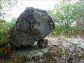 view gallery view galleryS13.4 km |  Balanced Rock - Sheffield Conservation Area, Erinsville, Ontario Balanced Rock - Sheffield Conservation Area, Erinsville, Ontario
in Nature's Balanced Rocks Just off the southern portion of the loop trail in Sheffield Conservation Area is this really interesting piece of geology. How did it happen that this large boulder is balancing on this smaller rock? posted by: Trail Blaisers location: Ontario, Canada date approved: 09/22/2016 last visited: never |
 view gallery view gallery N16.7 km N16.7 km
|  Cloyne Pioneer Cemetery - Cloyne, ON Cloyne Pioneer Cemetery - Cloyne, ON
in Worldwide Cemeteries Long-forgotten pioneer cemetery in Cloyne that has recently undergone preservation efforts. posted by: jiggs11 location: Ontario, Canada date approved: 09/21/2016 last visited: never |
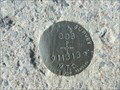 view gallery view galleryN16.7 km |  Ontario Ministry of Transportation Control Survey Disk 008-911313 - Cloyne, ON Ontario Ministry of Transportation Control Survey Disk 008-911313 - Cloyne, ON
in Canadian Benchmarks An Ontario MTO Control Survey Disk set in the sidewalk along Highway 41 in Cloyne. posted by: jiggs11 location: Ontario, Canada date approved: 09/25/2016 last visited: never |
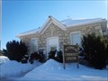
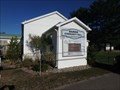 view gallery view galleryN16.9 km |  Barrie Community Hall - Cloyne, ON Barrie Community Hall - Cloyne, ON
in Municipal Community Centers Community Centre in Cloyne, ON. posted by: jiggs11 location: Ontario, Canada date approved: 09/22/2016 last visited: never |
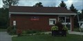 view gallery view galleryN16.9 km |  Cloyne PO K0H 1K0 Cloyne PO K0H 1K0
in Canada Post Offices Post office in rural Cloyne posted by: stinger503 location: Ontario, Canada date approved: 07/13/2022 last visited: never |
 view gallery view gallery SW18.5 km SW18.5 km
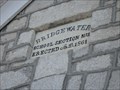
|  1861 - Bridgewater School - Actinolite, ON 1861 - Bridgewater School - Actinolite, ON
in Dated Buildings and Cornerstones Dated marker on the former Bridgewater School in Actinolite, built in 1861. posted by: jiggs11 location: Ontario, Canada date approved: 09/26/2016 last visited: never |
 view gallery view gallerySW18.5 km |  Bridgewater School - Actinolite, Ontario Bridgewater School - Actinolite, Ontario
in One-Room Schoolhouses A former one-room school house made of limestone that can be found in Actinolite, formerly known as Bridgewater. A town that had more people in it in the 1850s than now. posted by: Trail Blaisers location: Ontario, Canada date approved: 02/07/2014 last visited: 09/19/2016 |
 view gallery view gallerySW18.7 km | "THE FOUNDING OF ACTINOLITE" ~ Actinolite in Ontario Provincial Plaques This plaque describes the founding of Actinolite. posted by: Weathervane location: Ontario, Canada date approved: 05/28/2012 last visited: 01/28/2014 |
 view gallery view galleryE20.3 km | Arden United Church Cemetery - Ardendale, ON in Worldwide Cemeteries Small, well-kept cemetery located on Arden Road just south of Highway 7. posted by: jiggs11 location: Ontario, Canada date approved: 09/17/2016 last visited: never |
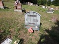 view gallery view galleryE20.3 km |  Hartwick Headstone - Arden Cemetery, Ontario Hartwick Headstone - Arden Cemetery, Ontario
in Homemade Tombstones A homemade headstone constructed with artificial wood 2x6's, greyish blue in color. I mistook it for zinc! posted by: model12 location: Ontario, Canada date approved: 08/23/2011 last visited: 08/24/2011 |
 view gallery view gallerySW20.4 km |  Peace Pole - Pearson Peace Park - Madoc, ON Peace Pole - Pearson Peace Park - Madoc, ON
in Peace Poles Old peace pole located in the Pearson Peace Park near Madoc, ON. posted by: jiggs11 location: Ontario, Canada date approved: 11/02/2015 last visited: 09/28/2016 |
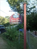
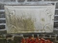 view gallery view gallerySE22 km | 1870 - Church of the Assumption of the Blessed Virgin Mary - Erinsville, ON in Dated Buildings and Cornerstones Cornerstone for the Church of the Assumption of the Bleesed Virgin Mary in Erinsville, ON, laid in 1870. posted by: jiggs11 location: Ontario, Canada date approved: 06/02/2016 last visited: 09/10/2016 |
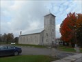 view gallery view gallerySE22 km |  Church of the Assumption of the Blessed Virgin Mary - Erinsville, ON Church of the Assumption of the Blessed Virgin Mary - Erinsville, ON
in Roman Catholic Churches Long-serving parish located on Hwy 41 in Erinsville, ON. posted by: jiggs11 location: Ontario, Canada date approved: 05/29/2016 last visited: 07/24/2022 |
|