 view gallery view gallery SW10.9 km SW10.9 km
|   T50N R75W S9 S10 S15 S16 - Campbell County, Wyoming T50N R75W S9 S10 S15 S16 - Campbell County, Wyoming
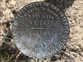
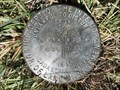
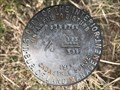
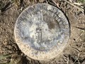
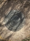
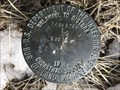
in Public Land Survey Marks This USDI-Bureau of Land Management section corner is located to the southwest of Fortification Creek. posted by:  Tom.dog Tom.dog location: Wyoming date approved: 04/08/2024 last visited: never |
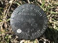
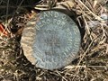
 view gallery view gallerySW11.4 km | T50N R75W S16 S15 N 1/16 - Campbell County, Wyoming in Public Land Survey Marks A sixteenth corner marker located on a ridge crest to the south of Fortification Creek. posted by: Tom.dog location: Wyoming date approved: 04/08/2024 last visited: never |
 view gallery view gallerySW11.6 km | T51N R76W S25 S36 R75W S30 S31 - Campbell County, Wyoming in Public Land Survey Marks A privately monumented section corner marker on the southwest side of the Fortification Creek drainage in far western Campbell County. posted by: Tom.dog location: Wyoming date approved: 05/08/2023 last visited: never |
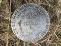
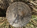
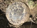
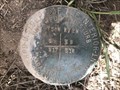
 view gallery view gallerySW11.7 km | T50N R75W S16 S15 1/4 - Campbell County, Wyoming in Public Land Survey Marks A quarter corner marker in the Fortification Creek country. posted by: Tom.dog location: Wyoming date approved: 04/08/2024 last visited: never |
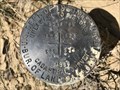
 view gallery view gallerySW11.9 km | T50N R75W S8 S9 S16 S17 - Campbell County, Wyoming in Public Land Survey Marks A section corner mark near Fortification Road, just to the southeast of a substation. posted by: Tom.dog location: Wyoming date approved: 04/08/2024 last visited: never |
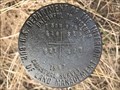
 view gallery view gallerySW11.9 km | T51N R76W S36 R75W S31 1/4 - Campbell County, Wyoming in Public Land Survey Marks A USDI-Bureau of Land Management quarter corner marker on the northeastern slopes of Antelope Draw. posted by: Tom.dog location: Wyoming date approved: 05/08/2023 last visited: never |
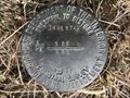
 view gallery view gallerySW12.1 km | T50N R75W S16 S15 S 1/16 - Campbell County, Wyoming in Public Land Survey Marks A USDI-Bureau of Land Management sixteenth corner marker roughly halfway between Fortification Road and Fortification Creek. posted by: Tom.dog location: Wyoming date approved: 04/08/2024 last visited: never |
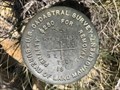 view gallery view gallerySW12.4 km | T51N R76W S36 R75W S31 T50N R76W S1 R75W S6 - Campbell County, Wyoming in Public Land Survey Marks This BLM U.S. Cadastral Survey township corner is located in between Antelope Draw and Carr Draw in far-western Campbell County. posted by: Tom.dog location: Wyoming date approved: 05/08/2023 last visited: never |
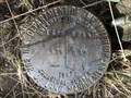
 view gallery view gallerySW12.4 km | T50N R75W S16 S15 S22 S21 - Campbell County, Wyoming in Public Land Survey Marks This section corner marker lies to the north of Fortification Road / Kinney Divide. posted by: Tom.dog location: Wyoming date approved: 04/08/2024 last visited: never |
 view gallery view gallery W12.4 km W12.4 km
| T51N R76W S25 S36 1/4 - Campbell County, Wyoming in Public Land Survey Marks USDI-Bureau of Land Management quarter corner marker on the edge of Carr Draw. posted by: Tom.dog location: Wyoming date approved: 05/08/2023 last visited: never |
 view gallery view gallery S12.6 km S12.6 km
| T50N R74W S19 S30 1/4 - Campbell County, Wyoming in Public Land Survey Marks A USDI-Bureau of Land Management quarter corner marker on the north side of Montgomery Road. posted by: Tom.dog location: Wyoming date approved: 05/08/2023 last visited: never |
 view gallery view gallerySW13 km | T51N R76W S36 T50N S1 1/4 - Campbell County, Wyoming in Public Land Survey Marks This USDI-Bureau of Land Management quarter corner marker is on a steep southern slope of Carr Draw. posted by: Tom.dog location: Wyoming date approved: 05/08/2023 last visited: never |
 view gallery view galleryW13.2 km | T51N R76W S26 S25 S36 S35 - Campbell County, Wyoming in Public Land Survey Marks A USDI-Bureau of Land Management section corner marker in western Campbell County. posted by: Tom.dog location: Wyoming date approved: 05/08/2023 last visited: never |
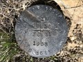
 view gallery view gallerySW13.5 km | T51N R76W S35 S36 1/4 - Campbell County, Wyoming in Public Land Survey Marks A USDI-Bureau of Land Management quarter corner marker in the Kinney Divide region of Campbell County. posted by: Tom.dog location: Wyoming date approved: 05/08/2023 last visited: never |
 view gallery view gallerySW13.8 km | T51N R76W S35 S36 T50N S2 S1 - Campbell County, Wyoming in Public Land Survey Marks This privately monumented section corner marker is located in far-western Campbell County. posted by: Tom.dog location: Wyoming date approved: 05/08/2023 last visited: never |
 view gallery view galleryS20.9 km | T49N R74W S14 S13 1/4 RM - Campbell County, Wyoming in Public Land Survey Marks A reference marker for a quarter corner monumented by the USDI-Bureau of Land Management. posted by: Tom.dog location: Wyoming date approved: 03/27/2023 last visited: never |
 view gallery view gallery E22 km E22 km
|  Gillette-Campbell County Airport Gillette-Campbell County Airport
in Airports Gillette, WY: Campbell County Airport posted by:  The Yoyo Man The Yoyo Man location: Wyoming date approved: 12/07/2008 last visited: 10/10/2022 |
 view gallery view galleryE22.5 km |  PLANE AZ MK (PV0264) - Campbell County, Wyoming PLANE AZ MK (PV0264) - Campbell County, Wyoming
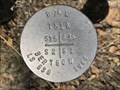
in Azimuth Benchmarks The azimuth mark for triangulation station PLANE, near the entrance to the Northeast Wyoming Regional Airport. posted by: Tom.dog location: Wyoming date approved: 07/02/2023 last visited: never |
 view gallery view galleryE22.5 km |  PLANE AZ MK (PV0264) - Campbell County, Wyoming PLANE AZ MK (PV0264) - Campbell County, Wyoming
in U.S. Benchmarks The azimuth mark for triangulation station PLANE, near the entrance to the Northeast Wyoming Regional Airport. posted by: Tom.dog location: Wyoming date approved: 01/08/2023 last visited: never |
 view gallery view galleryE23.2 km | T50N R72W S8 S9 S16 S17 - Campbell County, Wyoming in Public Land Survey Marks USDI-Bureau of Land Management section corner marker on the south side of Ratcliff Drive to the north of Gillette. posted by: Tom.dog location: Wyoming date approved: 05/08/2023 last visited: never |
 view gallery view gallery SE24 km SE24 km
| T50N R72W S17 S16 S21 S20 - Campbell County, Wyoming in Public Land Survey Marks This GLO section corner marker is located on the east side of US 14-16 on the north side of Gillette. posted by: Tom.dog location: Wyoming date approved: 06/12/2023 last visited: never |
 view gallery view galleryS24.9 km | T49N R74W S25 S36 1/4 - Campbell County, Wyoming in Public Land Survey Marks A USDI-Bureau of Land Management quarter corner marker to the north of North School Section Reservoir. posted by: Tom.dog location: Wyoming date approved: 03/27/2023 last visited: never |
 view gallery view galleryS25.6 km | T49N R74W S35 S36 1/4 - Campbell County, Wyoming in Public Land Survey Marks This USDI-Bureau of Land Management quarter corner marker is located on the northeast side of a slope that leads down to Wild Horse Creek. posted by: Tom.dog location: Wyoming date approved: 03/27/2023 last visited: never |
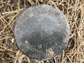
![Image for T49N R74W S35 S36 [T48N R74W S2] SC - Campbell County, Wyoming](https://img.geocaching.com/waymarking/small/ba47a67d-4188-45c6-8eae-bcb7b2836081.jpg) view gallery view galleryS26.4 km | T49N R74W S35 S36 [T48N R74W S2] SC - Campbell County, Wyoming in Public Land Survey Marks A USDI-Bureau of Land Management standard corner marker on the south side of Buffalo Cut Across Road. posted by: Tom.dog location: Wyoming date approved: 03/27/2023 last visited: never |
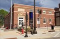 view gallery view gallerySE26.4 km |  Gillette Post Office (Former) - Gillette, WY Gillette Post Office (Former) - Gillette, WY
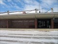
in WPA Projects Now home to the Gillette Brewing Company, the old Gillette Post Office is at 301 S Gillette Ave, Gillette, WY. It was constructed in 1935 using PWA funds. posted by: QuarrellaDeVil location: Wyoming date approved: 09/13/2020 last visited: 10/07/2022 |
|