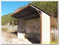
 view gallery view gallery E0.6 km E0.6 km
|   Gare du Poil - Majastres - Senes, Paca, France Gare du Poil - Majastres - Senes, Paca, France
in Wikipedia Entries La très modeste gare de Poil - Majastres posted by:  YvesProvence YvesProvence location: Provence-Alpes-Côte d'Azur, France date approved: 11/12/2017 last visited: never |
 view gallery view galleryE0.6 km |  Gare du Poil - Majastres - Senes, Paca, France Gare du Poil - Majastres - Senes, Paca, France
in Train Stations/Depots La très modeste gare de Poil - Majastres posted by: YvesProvence location: Provence-Alpes-Côte d'Azur, France date approved: 11/16/2017 last visited: never |
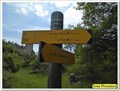
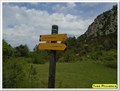
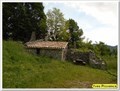 view gallery view gallery NW2.7 km NW2.7 km
|  Cabane de Creisset, Le Haut Villard - Beynes, France Cabane de Creisset, Le Haut Villard - Beynes, France
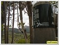
in Remote Backcountry Shelters Une cabane de l'ONF, près d'un village abandonné. / An ONF hut, near an abandoned village. posted by: YvesProvence location: Provence-Alpes-Côte d'Azur, France date approved: 02/28/2021 last visited: 03/02/2021 |
 view gallery view galleryNW2.7 km |  1030 m - Le Haut Village - Beynes, France 1030 m - Le Haut Village - Beynes, France
in Elevation Signs Cette altitude est présente sur un panneau à destination des randonneurs / This altitude is present on a sign intended for hikers posted by: YvesProvence location: Provence-Alpes-Côte d'Azur, France date approved: 02/28/2021 last visited: 03/02/2021 |
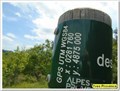
 view gallery view galleryNW2.7 km |  N 43° 58.999 E 006° 17.239 - Le Haut Village - Beynes, France N 43° 58.999 E 006° 17.239 - Le Haut Village - Beynes, France
in Permanent Geographic Coordinates Ces coordonnées sont sur un panneau à destination des randonneurs / These coordinates are on a sign for hikers posted by: YvesProvence location: Provence-Alpes-Côte d'Azur, France date approved: 02/28/2021 last visited: never |
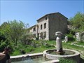
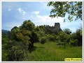 view gallery view galleryNW2.9 km |  Creisset - Beynes, France Creisset - Beynes, France
in Ghost Towns Le village abandonné du Creisset. The abandoned village of Creisset. posted by: YvesProvence location: Provence-Alpes-Côte d'Azur, France date approved: 02/28/2021 last visited: 03/02/2021 |
 view gallery view galleryNW2.9 km | Le village abandonné du Creisset. The abandoned village of Creisset. in Wikipedia Entries Le village abandonné du Creisset. The abandoned village of Creisset. posted by: YvesProvence location: Provence-Alpes-Côte d'Azur, France date approved: 02/28/2021 last visited: 03/02/2021 |
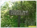 view gallery view galleryNW3.1 km |  Fontaine du Creisset - Creisset, France Fontaine du Creisset - Creisset, France
in Fountains La fontaine du village abandonné du Creisset. / The fountain of the abandoned village of Creisset. posted by: YvesProvence location: Provence-Alpes-Côte d'Azur, France date approved: 02/28/2021 last visited: 03/02/2021 |
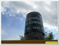 view gallery view galleryNW3.1 km | 1030 m - Carrefour du Creisset - Beynes, France in Elevation Signs Cette altitude est présente sur un panneau à destination des randonneurs / This altitude is present on a sign intended for hikers posted by: YvesProvence location: Provence-Alpes-Côte d'Azur, France date approved: 02/28/2021 last visited: 03/02/2021 |
 view gallery view galleryNW3.1 km | 43°59'07.7"N 6°17'09.7"E - Carrefour du Creisset - Beynes, France in Permanent Geographic Coordinates Ces coordonnées sont sur un panneau à destination des randonneurs / These coordinates are on a sign for hikers posted by: YvesProvence location: Provence-Alpes-Côte d'Azur, France date approved: 02/28/2021 last visited: never |
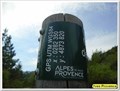
 view gallery view galleryNW3.1 km | 1015 m - Le Creisset - Beynes, France in Elevation Signs Cette altitude est présente sur un panneau à destination des randonneurs / This altitude is present on a sign intended for hikers posted by: YvesProvence location: Provence-Alpes-Côte d'Azur, France date approved: 02/28/2021 last visited: 03/02/2021 |
 view gallery view galleryNW3.1 km | 43°59'09.6"N 6°17'11.9"E - Le Creisset - Beynes, France in Permanent Geographic Coordinates Ces coordonnées sont sur un panneau à destination des randonneurs / These coordinates are on a sign for hikers posted by: YvesProvence location: Provence-Alpes-Côte d'Azur, France date approved: 02/28/2021 last visited: never |
 view gallery view gallery SW3.9 km SW3.9 km
| La fontaine du Poil - Senez, France in Fountains La fontaine du village posted by: YvesProvence location: Provence-Alpes-Côte d'Azur, France date approved: 03/06/2018 last visited: never |
 view gallery view gallerySW3.9 km | ") Le lavoir du Poil - Senez, France Le lavoir du Poil - Senez, France
in Lavoir (wash houses) Le lavoir du village posted by: YvesProvence location: Provence-Alpes-Côte d'Azur, France date approved: 03/06/2018 last visited: 05/11/2019 |
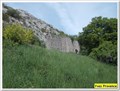 view gallery view gallerySW4 km | Le Poil - Senes, Paca, France in Ghost Towns Le Poil est ancienne commune française, dans les Alpes-de-Haute-Provence en région Provence-Alpes-Côte d'Azur, France posted by: YvesProvence location: Provence-Alpes-Côte d'Azur, France date approved: 08/04/2017 last visited: 05/11/2019 |
 view gallery view gallerySW4 km | 1210 m - Le Poil - Senez, France in Elevation Signs Ces coordonnées sont sur un panneau à destination des randonneurs posted by: YvesProvence location: Provence-Alpes-Côte d'Azur, France date approved: 05/12/2019 last visited: never |
 view gallery view gallerySW4 km | 43°56'13.6"N 6°17'05.6"E - Le Poil - Senez, France in Permanent Geographic Coordinates Ces coordonnées sont sur un panneau à destination des randonneurs posted by: YvesProvence location: Provence-Alpes-Côte d'Azur, France date approved: 05/12/2019 last visited: never |
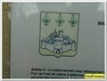
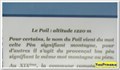 view gallery view gallerySW4 km | 1220 m - Le Poil - Senez, France in Elevation Signs L'altitude présente sur la panneau de présentation du hameau abandonné du Poil posted by: YvesProvence location: Provence-Alpes-Côte d'Azur, France date approved: 05/12/2019 last visited: never |
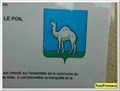
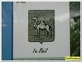 view gallery view gallerySW4 km |  Blason du Poil - Senez, France Blason du Poil - Senez, France
in Coats of Arms Le blason du Poil sur un panneau de présentation du hameau abandonné posted by: YvesProvence location: Provence-Alpes-Côte d'Azur, France date approved: 05/12/2019 last visited: never |
 view gallery view gallerySW4 km | Blason du Poil - Le Poil, Senez, France in Coats of Arms Le blason du hameau abandonné sur un panneau d'affichage municipal posted by: YvesProvence location: Provence-Alpes-Côte d'Azur, France date approved: 05/12/2019 last visited: never |
 view gallery view gallerySW4 km | Blason de Senez - Hameau du Poil, France in Coats of Arms Le blason de Senez, au hameau abandonné du Poil posted by: YvesProvence location: Provence-Alpes-Côte d'Azur, France date approved: 05/12/2019 last visited: never |
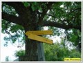
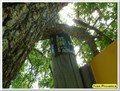
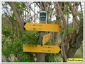
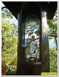 view gallery view galleryNW4.2 km |  Saint-Etienne - Forêt domaniale du Suy - Beynes, France Saint-Etienne - Forêt domaniale du Suy - Beynes, France
in Stained Glass Windows Un vitrail sur un chemin de randonnée / A stained glass window on a hiking trail posted by: YvesProvence location: Provence-Alpes-Côte d'Azur, France date approved: 02/28/2021 last visited: 03/02/2021 |
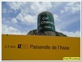 view gallery view galleryNW4.2 km | 1034 m - Le Col des Chandres - Beynes, France in Elevation Signs Cette altitude est présente sur un panneau à destination des randonneurs / This altitude is present on a sign intended for hikers posted by: YvesProvence location: Provence-Alpes-Côte d'Azur, France date approved: 02/28/2021 last visited: never |
 view gallery view galleryNW4.2 km |  Col des Chandres, Beynes, France Col des Chandres, Beynes, France
in Named Mountain Gaps Le Col des Chandres, dans la forêt domaniale du Suy / The Col des Chandres, in the national forest of Suy posted by: YvesProvence location: Provence-Alpes-Côte d'Azur, France date approved: 02/28/2021 last visited: 03/02/2021 |
 view gallery view galleryNW4.2 km | 43°59'43.8"N 6°16'42.7"E - Le Col des Chandres - Beynes, France in Permanent Geographic Coordinates Ces coordonnées sont sur un panneau à destination des randonneurs / These coordinates are on a sign for hikers posted by: YvesProvence location: Provence-Alpes-Côte d'Azur, France date approved: 02/28/2021 last visited: never |
|