 view gallery view gallery SW6.6 km SW6.6 km
|   Heinen (OZ1066) - Boise County, ID Heinen (OZ1066) - Boise County, ID
in U.S. Benchmarks Mt. Heinen USCGS Triangulation station posted by:  BadSquirrel BadSquirrel location: Idaho date approved: 09/28/2020 last visited: never |
 view gallery view gallery N15 km N15 km
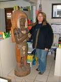
|  Idaho City cigar store Indian Idaho City cigar store Indian
in Cigar Store Indians The local 'cigar store' which also happens to be the Sinclair station. posted by: TeamRoadrunner location: Idaho date approved: 01/13/2008 last visited: 08/17/2010 |
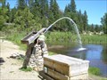 view gallery view galleryN15 km |  The Water Giant Fountain The Water Giant Fountain
in Fountains A converted "Monitor" water cannon that used to be used for the purpose of dredging gold from the nearby hills of the gold rush town of Idaho City. posted by: Touchstone location: Idaho date approved: 06/25/2007 last visited: 04/02/2009 |
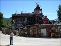 view gallery view galleryN15.6 km |  Idaho City Junk House Idaho City Junk House
in Junk Design Houses Something of a local icon, this house is festooned with discarded antique objects from this former gold rush town. posted by: Touchstone location: Idaho date approved: 06/24/2007 last visited: 04/02/2009 |
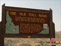 view gallery view gallerySW16.3 km |  The Old Toll Road - #266 The Old Toll Road - #266
in Idaho Historical Markers The Old Toll Road - Idaho Historical Sign# 266 posted by: Chooch72 location: Idaho date approved: 09/21/2007 last visited: 06/22/2012 |
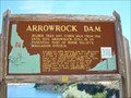 view gallery view gallerySW19.2 km | Arrowrock Dam #376 in Idaho Historical Markers Higher than any dam from 1915 to 1934, Arrowrock Dam is still an essential part of Boise Valley's irrigation system. posted by: Touchstone location: Idaho date approved: 06/24/2007 last visited: 06/22/2012 |
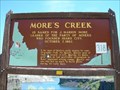 view gallery view gallerySW19.2 km | More's Creek #318 in Idaho Historical Markers More's Creek is named for J. Marion More, leader of the party of miners who found Idaho City, October 7 1862. posted by: Touchstone location: Idaho date approved: 06/24/2007 last visited: 06/22/2012 |
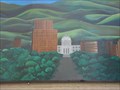 view gallery view gallerySW19.3 km | Seasons of Boise in Murals This mural depicts the different seasons in Idaho’s capital city.Boise City posted by: Rachel83642 location: Idaho date approved: 10/18/2006 last visited: 10/18/2006 |
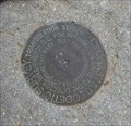 view gallery view gallerySW22.7 km | Shaw Mtn Benchmark - Boise, Idaho in U.S. Benchmarks Shaw Mountain US Coast & Geodetic Triangulation Station posted by: Chooch72 location: Idaho date approved: 06/09/2008 last visited: never |
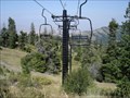 view gallery view gallery W25.1 km W25.1 km
|  Bogus Basin Ski Resort, Boise ID Bogus Basin Ski Resort, Boise ID
in Winter Sports Locations Medium sized resort, but big on runs. posted by:  cachegame cachegame location: Idaho date approved: 10/12/2006 last visited: 06/27/2010 |
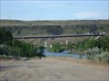
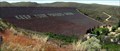 view gallery view gallerySW27 km |  Lucky Peak Dam Lucky Peak Dam
in Water Dams A large earthen embankment dam located 10 miles from Boise on Idaho State Highway 21. posted by: dingo262 location: Idaho date approved: 05/26/2009 last visited: 05/09/2011 |
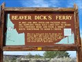 view gallery view gallerySW28.3 km | Beaver Dick's Ferry #359 in Idaho Historical Markers Situated along Highway 21 across the Boise River on the way to Idaho City. posted by: greywolf1242 location: Idaho date approved: 10/19/2007 last visited: 05/21/2018 |
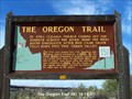 view gallery view gallerySW28.3 km | The Oregon Trail #153 in Idaho Historical Markers The first cart passed here with Spalding and Whitman, pioneer missionaries, in 1836. posted by: greywolf1242 location: Idaho date approved: 10/19/2007 last visited: 10/15/2019 |
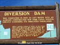 view gallery view gallerySW28.6 km | Diversion Dam #343 in Idaho Historical Markers This waymark is situated along Hwy 21 just north of the Boise River on the way to Idaho City. posted by: greywolf1242 location: Idaho date approved: 10/19/2007 last visited: 11/08/2011 |
 view gallery view gallerySW28.6 km |  The Idaho Shakespeare Festival - Boise, ID The Idaho Shakespeare Festival - Boise, ID
in William Shakespeare A wonderful open-air amphitheater that features some of the best Shakespeare performances anywhere. posted by: cachegame location: Idaho date approved: 11/14/2006 last visited: 10/27/2008 |
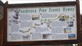 view gallery view gallerySW28.6 km |  Ponderosa Pine Scenic Byway - Boise Diversion Dam - Boise, ID Ponderosa Pine Scenic Byway - Boise Diversion Dam - Boise, ID
in National Scenic Byways Located on E Highway 21 in Boise, Idaho. posted by: lazyCachers location: Idaho date approved: 06/04/2008 last visited: 08/21/2008 |
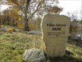 view gallery view gallerySW28.8 km | William Shakespeare Park - Boise, ID in William Shakespeare A nice picnic park located near the Idaho Shakespeare Festival posted by: cachegame location: Idaho date approved: 11/21/2006 last visited: 10/27/2008 |
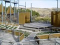
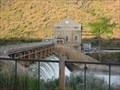 view gallery view gallerySW28.8 km | Boise Diversion Dam - Boise, ID in Water Dams Located on E Highway 21 in Boise, Idaho. posted by: lazyCachers location: Idaho date approved: 06/08/2008 last visited: 11/28/2009 |
 view gallery view gallerySW28.8 km |  Beaver Dick's Ferry Bridge - Boise, ID Beaver Dick's Ferry Bridge - Boise, ID
in Bungee Jump Sites This bungee jump site is located just 15 minutes from downtown, Boise, Idaho, USA. posted by: Marine Biologist location: Idaho date approved: 06/01/2008 last visited: 08/21/2008 |
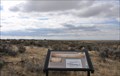
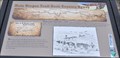
 view gallery view gallerySW29.1 km | Bonneville Point in Idaho Historical Markers This historic marker and monument stands at a historic spot on the Oregon Trail southeast of Boise. It was originally erected by the local Kiwanis Club in 1927. posted by: brwhiz location: Idaho date approved: 12/17/2013 last visited: never |
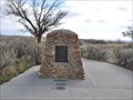 view gallery view gallerySW29.1 km |  Bonneville Point Monument Bonneville Point Monument
in Kiwanis International Markers The Kiwanis Club of Boise erected the Bonneville Point monument in 1927 at this historic spot on the Oregon Trail. posted by: brwhiz location: Idaho date approved: 12/06/2013 last visited: never |
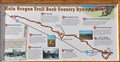 view gallery view gallerySW29.1 km | Main Oregon Trail Back Country Byway ~ Bonneville Point in National Scenic Byways This is the northernmost easily-accessible point on this section of the historic Oregon Trail southeast of Boise. posted by: brwhiz location: Idaho date approved: 12/08/2013 last visited: never |
 view gallery view gallerySW29.8 km | Main Oregon Trail Back Country Byway ~ Blacks Creek Road Crossing in National Scenic Byways At his point, the Oregon Trail crosses modern-day Blacks Road on its way up along the ridge to Bonneville Point. posted by: brwhiz location: Idaho date approved: 12/08/2013 last visited: never |
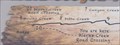 view gallery view gallerySW29.8 km |  Blacks Creek Road Crossing Blacks Creek Road Crossing
in 'You Are Here' Maps You Are Here at the point where the Oregon Trail crosses modern-day Blacks Road on its way up along the ridge to Bonneville Point. posted by: brwhiz location: Idaho date approved: 12/07/2013 last visited: never |
 view gallery view gallerySW29.8 km | Blacks Creek Road Crossing in Idaho Historical Markers This historic marker at the point where the Oregon Trail crosses modern-day Blacks Road on its way up along the ridge to Bonneville Point. posted by: brwhiz location: Idaho date approved: 12/17/2013 last visited: never |
|