 view gallery view gallery E8.2 km E8.2 km
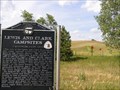
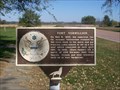
|   LEWIS AND CLARK CAMPSITES: AUGUST 23, 24, AND 25, 1804 LEWIS AND CLARK CAMPSITES: AUGUST 23, 24, AND 25, 1804
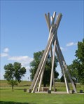
in Nebraska Historical Markers The men of the Lewis and Clark Expedition saw many natural curiosities during their trek to the Pacific Ocean. posted by:  MNSearchers MNSearchers location: Nebraska date approved: 07/25/2006 last visited: 08/01/2017 |
 view gallery view galleryE12.1 km | THE IONIA "VOLCANO" in Nebraska Historical Markers On August 24, 1804, the Lewis and Clark Expedition, traveling up the Missouri River, passed a bluff about 180 to 190 feet high. posted by: MNSearchers location: Nebraska date approved: 07/25/2006 last visited: 07/22/2006 |
 view gallery view gallery NE12.2 km NE12.2 km
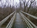
|  Cotton Park Suspension Bridge - Vermillion, SD Cotton Park Suspension Bridge - Vermillion, SD
in Pedestrian Suspension Bridges A suspension bridge in Cotton Park that brings the pedestrian to an island in the middle of the Vermillion River. posted by: beta59 location: South Dakota date approved: 03/28/2011 last visited: 02/18/2012 |
 view gallery view gallery NW12.4 km NW12.4 km
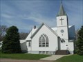
|  Bergen Lutheran - SD Bergen Lutheran - SD
in Country Churches Historic and well-maintained rural church near the Missouri River. posted by: plainsdrifter358 location: South Dakota date approved: 05/12/2008 last visited: 04/23/2008 |
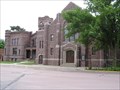
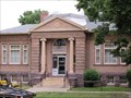 view gallery view galleryNE12.7 km |  Carnegie Library Carnegie Library
in U.S. National Register of Historic Places Carnegie Library now used as a Law Office. posted by: MNSearchers location: South Dakota date approved: 06/24/2006 last visited: 03/26/2011 |
 view gallery view galleryNE12.9 km | The First Baptist Church in U.S. National Register of Historic Places First Baptist Church in Vermillion South Dakota. posted by: MNSearchers location: South Dakota date approved: 06/23/2006 last visited: 12/28/2011 |
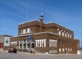
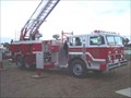 view gallery view galleryNE12.9 km |  Vermillion, SD Vermillion, SD
in Fire Fighting Vehicles A few trucks from the Vermillion, SD volunteer fire department. posted by: TheNinnymuggins location: South Dakota date approved: 11/13/2005 last visited: 03/26/2011 |
 view gallery view galleryNE13 km |  The Missouri River Historic Highway & Vermillion The Missouri River Historic Highway & Vermillion
in South Dakota Historical Markers Vermillion early history and description of the Missouri River historic highway. posted by: plainsdrifter358 location: South Dakota date approved: 05/24/2006 last visited: 08/08/2007 |
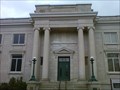 view gallery view galleryNE13.4 km |  National Music Museum - Vermillion, SD National Music Museum - Vermillion, SD
in History Museums The National Music Museum is a one of a kind museum with displays of all types of musical instruments from all cultures and covering the history of instruments. posted by: beta59 location: South Dakota date approved: 03/27/2011 last visited: 12/28/2011 |
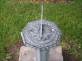 view gallery view galleryNE13.4 km |  University of South Dakota Sun Dial University of South Dakota Sun Dial
in Sundials Sundial located on the grounds of University of South Dakota in Vermillion SD. posted by: MNSearchers location: South Dakota date approved: 07/12/2006 last visited: 03/26/2011 |
 view gallery view galleryE17.5 km | Fort Vermillion in South Dakota Historical Markers An old cavalry fort located on the Vermillion River in Clay County, South Dakota posted by: NGComets location: South Dakota date approved: 11/09/2010 last visited: 01/29/2011 |
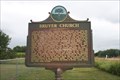 view gallery view galleryNE18.2 km | Bruyer Church -- nr Vermillion SD in South Dakota Historical Markers This roadside marker is located at a small cemetery a few miles east of Vermillion SD on the SD state highway 50 posted by: Benchmark Blasterz location: South Dakota date approved: 01/23/2014 last visited: 08/02/2013 |
 view gallery view galleryNE19.6 km | First Rural Electric Cooperative in South Dakota Historical Markers Site of the first rural electric cooperative in South Dakota. posted by: plainsdrifter358 location: South Dakota date approved: 11/26/2006 last visited: 08/07/2007 |
 view gallery view gallery N20.8 km N20.8 km
| Spirit Mound in U.S. National Register of Historic Places Spirit Mound is located approximately six miles north of Vermillion, South Dakota on Hwy. 19. A state park, Spirit Mound Historic Prairie, was recently established, and the landscape is being restored. An interpretive sign is located at the I-29 Information Center near Junction City, and a small parking lot and day use area will be established by 2004 at the NW corner of the intersection of State Hwy. 19 and 312th St. For more information, visit the Spirit Mound Historic Prairie website or call posted by: MNSearchers location: South Dakota date approved: 06/27/2006 last visited: 07/30/2013 |
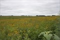 view gallery view galleryN20.8 km |  Spirit Mound -- nr Vermillion SD Spirit Mound -- nr Vermillion SD
in Flower Fields The beautiful and mystical Spirit Mound prairie has been restored and preserved. Many kinds of flowers, grasses, and vines grow here. posted by: Benchmark Blasterz location: South Dakota date approved: 12/18/2013 last visited: 07/31/2013 |
 view gallery view gallery W20.9 km W20.9 km
| City Hall and Auditorium - Hartington, Nebraska in U.S. National Register of Historic Places This Prairie style building was constructed 1n 1922. posted by:  NevaP NevaP location: Nebraska date approved: 05/10/2008 last visited: never |
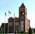 view gallery view galleryW20.9 km | Cedar County Courthouse, Hartington, Nebraska in U.S. National Register of Historic Places This Romanesque style courthouse was built in 1891 posted by: NevaP location: Nebraska date approved: 05/10/2008 last visited: 01/02/2016 |
 view gallery view galleryW20.9 km |  Cedar County Courthouse, Hartington, Nebraska Cedar County Courthouse, Hartington, Nebraska
in Courthouses This beautiful Romanesque style courthouse was constructed in 1891. posted by: NevaP location: Nebraska date approved: 05/08/2008 last visited: 01/02/2016 |
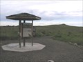
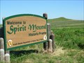 view gallery view galleryN20.9 km |  SPIRIT MOUND A NATIONAL HISTORIC SITE Vermillion, South Dakota SPIRIT MOUND A NATIONAL HISTORIC SITE Vermillion, South Dakota
in Lewis and Clark Trail On August 25, 1804, Lewis and Clark walked to this conical hill which the Indians believed to be the residence of "little people or Spirits." posted by:  RB2 RB2 location: South Dakota date approved: 06/27/2007 last visited: 07/30/2013 |
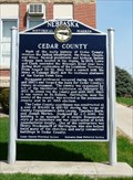 view gallery view galleryW20.9 km | Cedar County in Nebraska Historical Markers This marker, located in front of the Cedar County Nebraska courthouse relates history of the county.
posted by: NevaP location: Nebraska date approved: 05/11/2008 last visited: 01/02/2016 |
 view gallery view galleryW21.1 km | Hartington, Home of two Nebraska Governors in Nebraska Historical Markers The Marker, located by the Cedar County Historical Museum, honors two of Nebraska's governors who came from Hartington. posted by: NevaP location: Nebraska date approved: 05/11/2008 last visited: 04/08/2023 |
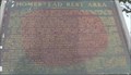 view gallery view galleryNE22.4 km |  Homestead Rest Area - Junction City SD Homestead Rest Area - Junction City SD
in Homesteads An interesting plaque in a rest area just off I-29 (exit 26) at S.D. Hwy 50. posted by: PeterNoG location: South Dakota date approved: 04/18/2008 last visited: 08/10/2017 |
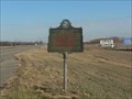
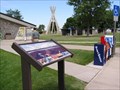
 view gallery view galleryNE22.4 km | The Missouri River was Historic Highway - Junction City in South Dakota Historical Markers Highway 50 meanders through the prairie from just east of Vermillion to Pukwana, South Dakota.
This historical marker is located at one of the few rest stops in South Dakota. posted by: MNSearchers location: South Dakota date approved: 07/10/2006 last visited: 08/07/2007 |
 view gallery view galleryNE22.4 km | The Great Missouri River in South Dakota Historical Markers The Missouri is the continents longest river. posted by: MNSearchers location: South Dakota date approved: 07/10/2006 last visited: 03/26/2011 |
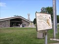
 view gallery view galleryNE22.4 km |  Homestead Rest Area - Junction City SD Homestead Rest Area - Junction City SD
in Highway Rest Areas Homestead Rest Area near Junction City SD posted by: kJfishman location: South Dakota date approved: 08/06/2015 last visited: 08/10/2017 |
|