 view gallery view gallery N1.1 km N1.1 km
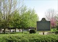
|   “JAMES PARIS LEE 1831 -1904” - Wallaceburg “JAMES PARIS LEE 1831 -1904” - Wallaceburg
in Ontario Provincial Plaques Inventor of the Lee-Enfield rifle - the first prototype was made and tested here. posted by:  Hard Oiler Hard Oiler location: Ontario, Canada date approved: 05/05/2007 last visited: 05/11/2015 |
 view gallery view gallery NW1.3 km NW1.3 km
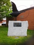
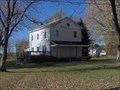
|  The Black Goose - Wallaceburg, Ontario The Black Goose - Wallaceburg, Ontario
in Figurative Public Sculpture This sculpture is of the Black Goose from the original folklore of the Baldoon Mysteries written by Neil T. McDonald in 1871. posted by:  Darlinsue Darlinsue location: Ontario, Canada date approved: 05/12/2015 last visited: never |
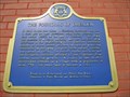
 NW8.9 km |  Baldoon Mystery Baldoon Mystery
in Weird Story Locations The coordinates will take you to plaques marking the site of the Baldoon Mystery, a story of supernatural events which took place between 1830 and 1840. posted by: Hard Oiler location: Ontario, Canada date approved: 08/16/2005 last visited: 05/11/2015 |
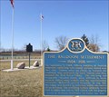 view gallery view galleryNW8.9 km | The Baldoon Settlement in Ontario Provincial Plaques This plaque marks the short-lived Baldoon Settlement established in 1804 by 15 families of Scottish immigrants posted by: Hard Oiler location: Ontario, Canada date approved: 03/19/2006 last visited: 05/11/2015 |
 view gallery view gallery E9.5 km E9.5 km
|  Chatham-Kent Station 5 Chatham-Kent Station 5
in Firehouses Chatham-Kent Fire Station # 5 is located in the Village of Tupperville. posted by:  chartmaker chartmaker location: Ontario, Canada date approved: 01/26/2015 last visited: 06/01/2015 |
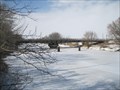 view gallery view galleryE9.5 km |  Tupperville Swing Bridge Tupperville Swing Bridge
in Moving Bridges This is a metal deck girder swing bridge. posted by: Cargoman location: Ontario, Canada date approved: 04/06/2011 last visited: 06/01/2015 |
 view gallery view gallery S11.1 km S11.1 km
|  North Lakeshore Trail North Lakeshore Trail
in Self Guided Walks and Trails A Trailhead sign for the North Lakeshore Trail. It contains information about the trail and a map to direct trail users on their way. posted by: ChathamKentTrails location: Ontario, Canada date approved: 09/03/2015 last visited: 11/07/2020 |
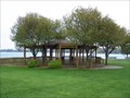 view gallery view gallery W12.7 km W12.7 km
|  June E. Crocker Memorial Gazebo - Algonac, Michigan June E. Crocker Memorial Gazebo - Algonac, Michigan
in Gazebos The June E. Crocker Memorial Gazebo was dedicated on June 27, 1991. It is located at the northeast end of the river front park just north of the Historical Museum. posted by: Leader1 location: Michigan date approved: 06/11/2010 last visited: 03/08/2023 |
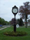 view gallery view galleryW12.7 km |  Algonac Town Clock - Algonac, Michigan Algonac Town Clock - Algonac, Michigan
in Town Clocks Town Clock in Algonac, MI Along St. Clair River Drive. posted by: Leader1 location: Michigan date approved: 06/12/2010 last visited: 03/08/2023 |
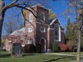 view gallery view galleryW12.7 km |  Saint Andrew's Parish/Saint Andrew's Church Saint Andrew's Parish/Saint Andrew's Church
in Michigan Historical Markers The Church building is now a private residence and the marker was moved to the above location on the southwest side of the Museum of Local History at 1240 St. Clair River Road. The Church building is up the street at 1507 St. Clair River Road. posted by: S5280ft location: Michigan date approved: 11/01/2006 last visited: 03/08/2023 |
 view gallery view galleryW12.7 km | Clay Township Library in Michigan Historical Markers It is now the location of the Algonac-Clay [Township] Historical Society. Located on the river side of St. Clair River Road at the end of Clay Street. Parking available on site. posted by: S5280ft location: Michigan date approved: 11/02/2006 last visited: 03/08/2023 |
 view gallery view galleryW12.9 km | Water Speed Capital in Michigan Historical Markers Located in the City of Algonac Park between St.Clair River Road and the St. Clair River. Parking available in many places along the park. posted by: S5280ft location: Michigan date approved: 11/02/2006 last visited: 01/14/2023 |
 view gallery view galleryW12.9 km |  Old Glory - Algonac, MI Old Glory - Algonac, MI
in Painted Hydrants Painted hydrant located along St. Clair Rive Drive in Algonac, Michigan with a few of the St. Clair River. posted by: bobfrapples8 location: Michigan date approved: 04/13/2023 last visited: never |
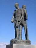
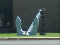 view gallery view galleryW12.9 km |  Seafarer's Anchor Seafarer's Anchor
in Anchors Anchor standing guard at the Seafarer's building in Algonac. posted by: paldog0603 location: Michigan date approved: 08/25/2009 last visited: 06/02/2015 |
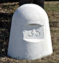 view gallery view galleryNW13.7 km |  24U3270 - MMMCCLXX - IBC Marker 35 24U3270 - MMMCCLXX - IBC Marker 35
in Canadian Benchmarks IBC Marker 35 is one of the land based International Boundary Commission markers used to define the US/Canada border along the St Clair River between Michigan and Ontario posted by: Hard Oiler location: Ontario, Canada date approved: 03/19/2006 last visited: 06/10/2020 |
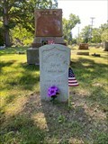 view gallery view galleryW13.7 km |  Algonac Civil War veteran honored in grave dedication - Algonac, MI Algonac Civil War veteran honored in grave dedication - Algonac, MI
in News Article Locations News story about a Civil War veteran from Michigan who served under General Custer at Gettysburg getting a proper gravestone. posted by: bobfrapples8 location: Michigan date approved: 03/08/2023 last visited: never |
 view gallery view galleryE15.1 km |  CNHS - Reverend Josiah Henson 1789-1883 CNHS - Reverend Josiah Henson 1789-1883
in Canadian National Historic Sites Community leader, Underground Railroad conductor, famous Black Canadian by virtue of his association with the main character in "Uncle Tom's Cabin" posted by: Hard Oiler location: Ontario, Canada date approved: 10/25/2006 last visited: 05/02/2021 |
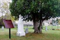
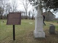 view gallery view galleryE15.1 km |  Josiah Henson - Uncle Tom's Cabin - Dresden, Ontario Josiah Henson - Uncle Tom's Cabin - Dresden, Ontario
in Grave of a Famous Person This Grave is located at the historic site of Uncle Toms Cabin at 29251 Uncle Tom's Road Dresden, Ontario Canada. posted by: DougandSandra location: Ontario, Canada date approved: 05/04/2014 last visited: 05/02/2021 |
 view gallery view galleryE15.1 km |  Uncle Tom's Cabin Uncle Tom's Cabin
in Underground Railroad Sites Uncle Tom's Cabin historic site in Dresden Ontario. A final stop on the Underground Railway. The coordinates are for the grave of Josiah Henson – the “Uncle Tom” in Harriet Beecher Stowe's famous novel. posted by: Hard Oiler location: Ontario, Canada date approved: 11/16/2006 last visited: 05/02/2021 |
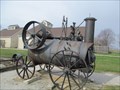 view gallery view galleryE15.1 km |  Steam Engine Saw Mill - Uncle Tom's Cabin - Dresden, Ontario Steam Engine Saw Mill - Uncle Tom's Cabin - Dresden, Ontario
in Preserved Machines on Public Display This machine is on display at Uncle Tom's Cabin historic site in Dresden Ontario. posted by: DougandSandra location: Ontario, Canada date approved: 04/19/2014 last visited: 06/01/2015 |
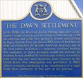 view gallery view galleryE15.3 km | "THE DAWN SETTLEMENT" - Dresden in Ontario Provincial Plaques Located at the Uncle Tom’s Cabin Historic Site in Dresden, the plaque recognizes the establishment of the Dawn Settlement as a refuge for escaped slaves. posted by: Hard Oiler location: Ontario, Canada date approved: 10/24/2006 last visited: 05/02/2021 |
 view gallery view galleryW15.8 km | Stewart Farm/Memoir of Aura Stewart in Michigan Historical Markers Located on the south side of Stewart Road east of Golf Course Road, on beautiful Harsons Island. Take the ferry to get there. You will have to park beside the road to visit the marker. posted by: S5280ft location: Michigan date approved: 11/02/2006 last visited: 01/06/2014 |
 view gallery view galleryW16.3 km | Harsen House in Michigan Historical Markers This private home is located on the west side of Golf Course Road on beautiful Harsons Island. Take the ferry to get there. You're on your own for parking. posted by: S5280ft location: Michigan date approved: 11/02/2006 last visited: 01/06/2014 |
 view gallery view galleryE16.6 km | "THE FOUNDING OF DRESDEN" in Ontario Provincial Plaques An Ontario Historical Plaque, on a building on one of the main intersections in Dresden. posted by: Knightwatchman location: Ontario, Canada date approved: 03/06/2011 last visited: 05/02/2021 |
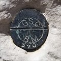 view gallery view galleryE16.6 km | Geodetic Survey of Canada 11U370 - Dresden Post Office in Canadian Benchmarks Geodetic Survey of Canada 11U370 - Dresden Post Office posted by: BWJM location: Ontario, Canada date approved: 05/03/2021 last visited: 05/02/2021 |
|