 view gallery view gallery W1.4 km W1.4 km
|   Petín - Ourense, España Petín - Ourense, España
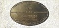
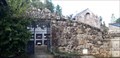
in Vértices Geodésicos Punto de referencia en la fachada de la Casa Consistorial con Coordenadas Geográficas Permanentes grabadas // Benchmark on the facade of the Town Hall with Permanent Geographic Coordinates engraved posted by:  xeocach xeocach location: Galicia, Spain date approved: 11/15/2022 last visited: never |
 view gallery view galleryW1.4 km |  304m - Petín, Ourense, España 304m - Petín, Ourense, España
in Elevation Signs Elevación sobre el nivel medio del Mediterráneo en Alicante // Elevation above the mean level of the Mediterranean Sea in Alicante posted by: xeocach location: Galicia, Spain date approved: 11/15/2022 last visited: never |
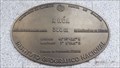
 view gallery view galleryW1.4 km |  N 42º 22’ 57,5’’ W 7º 7’ 28,2’’ - Petín, Ourense, España N 42º 22’ 57,5’’ W 7º 7’ 28,2’’ - Petín, Ourense, España
in Permanent Geographic Coordinates Punto de referencia en la fachada de la Casa Consistorial con Coordenadas Geográficas Permanentes grabadas // Benchmark on the facade of the Town Hall with Permanent Geographic Coordinates engraved posted by: xeocach location: Galicia, Spain date approved: 11/15/2022 last visited: never |
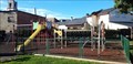 view gallery view galleryW1.4 km |  Parque da Casa do Concello - Petín, Ourense, España Parque da Casa do Concello - Petín, Ourense, España
in Public Playgrounds Parque infantil en la zona verde que rodea la Casa Consistorial // Children's playground in the green area surrounding the Town Hall posted by: xeocach location: Galicia, Spain date approved: 02/01/2023 last visited: never |
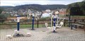
 view gallery view gallery NW1.4 km NW1.4 km
|  O Aguillón - A Rúa, Ourense, España O Aguillón - A Rúa, Ourense, España
in Fitness Trails Área de entrenamiento físico en un lateral del antiguo campo de fútbol de O Aguillón // Physical training area on one side of the old O Aguillón soccer field posted by: xeocach location: Galicia, Spain date approved: 02/01/2023 last visited: never |
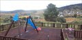
 view gallery view galleryNW1.4 km | O Aguillón - A Rúa, Ourense, España in Public Playgrounds Parque infantil en el área recreativa de O Aguillón // Children's playground in the recreational area of O Aguillón posted by: xeocach location: Galicia, Spain date approved: 02/01/2023 last visited: never |
 view gallery view gallery N1.9 km N1.9 km
| A Rúa - Ourense, España in Vértices Geodésicos Punto de referencia en la fachada de la Casa Consistorial con Coordenadas Geográficas Permanentes grabadas // Benchmark on the facade of the Town Hall with Permanent Geographic Coordinates engraved posted by: xeocach location: Galicia, Spain date approved: 02/03/2023 last visited: never |
 view gallery view galleryN1.9 km | 308m - A Rúa, Ourense, España in Elevation Signs Elevación sobre el nivel medio del Mediterráneo en Alicante // Elevation above the mean level of the Mediterranean Sea in Alicante posted by: xeocach location: Galicia, Spain date approved: 02/01/2023 last visited: never |
 view gallery view galleryN1.9 km | N42º 23’ 42,5’’ W7º 6’ 50,9’’ - A Rúa, Ourense, España in Permanent Geographic Coordinates Marca de nivel en la fachada de la Casa Consistorial con Coordenadas Geográficas Permanentes grabadas // Level mark on the facade of the Town Hall with Permanent Geographic Coordinates posted by: xeocach location: Galicia, Spain date approved: 02/01/2023 last visited: never |
 view gallery view galleryNW1.9 km |  Ponte da Cigarrosa - Petín, Ourense, España Ponte da Cigarrosa - Petín, Ourense, España
in Arch Bridges Puente de origen romano sobre el río Sil // Bridge of Roman origin over the river Sil posted by: xeocach location: Galicia, Spain date approved: 11/06/2022 last visited: never |
 view gallery view galleryNW1.9 km |  A Ponte da Cigarrosa - Petín, Ourense, España A Ponte da Cigarrosa - Petín, Ourense, España
in Wikipedia Entries Puente de origen romano sobre el río Sil // Bridge of Roman origin over the river Sil posted by: xeocach location: Galicia, Spain date approved: 11/06/2022 last visited: never |
 view gallery view galleryNW1.9 km |  Ponte da Cigarrosa - Petín, Ourense, España Ponte da Cigarrosa - Petín, Ourense, España
in Orphaned Bridges Puente de origen romano sobre el río Sil, en los años 80 del siglo XX se construyó otro río abajo y se convirtió en peatonal // Bridge of Roman origin over the river Sil, in the 1980s another was built downstream and became pedestrian posted by: xeocach location: Galicia, Spain date approved: 06/17/2023 last visited: never |
 view gallery view galleryNW1.9 km |  Ponte da Cigarrosa - Petín, Ourense, España Ponte da Cigarrosa - Petín, Ourense, España
in Stone Bridges Puente de origen romano sobre el río Sil // Bridge of Roman origin over the river Sil posted by: xeocach location: Galicia, Spain date approved: 11/11/2022 last visited: never |
 view gallery view galleryN2.6 km |  N-120 Km465,5 – A Rúa, Ourense, España N-120 Km465,5 – A Rúa, Ourense, España
in Solitary Silos Silo de vialidad invernal // Winter road silo posted by: xeocach location: Galicia, Spain date approved: 05/29/2023 last visited: never |
 view gallery view galleryW4 km | Área infantil As Escolas - Seadur, Ourense, España in Public Playgrounds Parque infantil en la esplanada frente a las antiguas escuelas unitarias // Children's playground on the esplanade in front of the old unitary schools posted by: xeocach location: Galicia, Spain date approved: 01/31/2023 last visited: never |
 view gallery view galleryW4 km | Área de exercicios As Escolas - Seadur, Ourense, España in Fitness Trails Máquinas para ejercicios de mantrenimiento en la esplanada frente a las antiguas escuelas unitarias // Machines for maintenance exercises on the esplanade in front of the old unitary schools posted by: xeocach location: Galicia, Spain date approved: 01/31/2023 last visited: never |
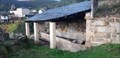 view gallery view galleryW4.2 km | ") O lavadoiro do Laia - Seadur, Ourense, España O lavadoiro do Laia - Seadur, Ourense, España
in Lavoir (wash houses) Lavadero en las inmediaciones del pueblo // Lavoir in the vicinity of the town posted by: xeocach location: Galicia, Spain date approved: 02/01/2023 last visited: never |
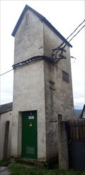 view gallery view galleryW4.2 km |  32CE93 - Seadur, Ourense, España 32CE93 - Seadur, Ourense, España
in Historic Transformer Sub-Stations Buildings Subestación transformadora ubicada en Seadur // Transformer substation tower located in Seadur posted by: xeocach location: Galicia, Spain date approved: 01/29/2023 last visited: never |
 view gallery view galleryW4.2 km |  Cemiterio - Seadur, Ourense, España Cemiterio - Seadur, Ourense, España
in Worldwide Cemeteries Situado detrás de la iglesia parroquial // Located behind the parish church posted by: xeocach location: Galicia, Spain date approved: 02/02/2023 last visited: never |
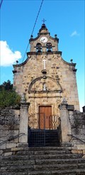 view gallery view galleryW4.2 km |  Igrexa de Santa Mariña de Seadur - Larouco, Ourense, España Igrexa de Santa Mariña de Seadur - Larouco, Ourense, España
in Roman Catholic Churches Iglesia parroquial de Seadur // Seadur Parish Church posted by: xeocach location: Galicia, Spain date approved: 11/14/2022 last visited: never |
 view gallery view galleryW4.2 km | Igrexa de Santa Mariña de Seadur - Larouco, Ourense, España in This Old Church Iglesia parroquial de Seadur // Seadur Parish Church posted by: xeocach location: Comunidad de Madrid, Spain date approved: 11/14/2022 last visited: never |
 view gallery view galleryW4.2 km | Igrexa de Santa Mariña - Seadur, Ourense, España in Country Churches Iglesia parroquial de Seadur // Seadur Parish Church posted by: xeocach location: Galicia, Spain date approved: 01/12/2023 last visited: never |
 view gallery view galleryW4.2 km |  Santa Mariña - Seadur, Ourense, España Santa Mariña - Seadur, Ourense, España
in Statues of Religious Figures Representación de la patrona del pueblo cuya festividad se celebra el 18 de julio // Representation of the patron saint of the town whose festival is celebrated on July 8 posted by: xeocach location: Galicia, Spain date approved: 02/01/2023 last visited: never |
 view gallery view galleryW4.2 km |  As campás da igrexa de Santa Mariña - Seadur, Ourense, España As campás da igrexa de Santa Mariña - Seadur, Ourense, España
in Bell Towers Campanario de la iglesia parroquial de Seadur // Bell tower of the parish church of Seadur posted by: xeocach location: Galicia, Spain date approved: 03/07/2023 last visited: never |
 view gallery view galleryW4.2 km |  Sendeirismo dende A Cancela - Seadur, Ourense, España Sendeirismo dende A Cancela - Seadur, Ourense, España
in Direction and Distance Arrows ¿A dónde nos llevan las rutas de senderismo que pasan por el pueblo? // Where do the hiking trails that pass through the town take us? posted by: xeocach location: Galicia, Spain date approved: 04/18/2023 last visited: never |
|