 view gallery view gallery W6.8 km W6.8 km
|   Castillo de O Bolo - Ourense, España Castillo de O Bolo - Ourense, España
in Castles Desde el medievo protege O Bolo y su entorno // Since the Middle Ages, it has protected O Bolo and its surroundings posted by:  xeocach xeocach location: Galicia, Spain date approved: 08/06/2023 last visited: never |
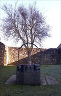 view gallery view galleryW6.8 km |  Pozo del castillo - O Bolo, Ourense, España Pozo del castillo - O Bolo, Ourense, España
in Draw Wells El pozo del aljibe del castillo // The draw well of the castle cistern posted by: xeocach location: Galicia, Spain date approved: 08/06/2023 last visited: never |
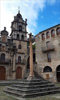
 view gallery view galleryW7.1 km |  O Bolo - Ourense, España O Bolo - Ourense, España
in Vértices Geodésicos Marca de nivel en la fachada de la Casa Consistorial con Coordenadas Geográficas Permanentes grabadas // Level mark on the facade of the Town Hall with Permanent Geographic Coordinates posted by: xeocach location: Galicia, Spain date approved: 01/04/2023 last visited: never |
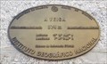
 view gallery view galleryW7.1 km |  746m - O Bolo, Ourense, España 746m - O Bolo, Ourense, España
in Elevation Signs Elevación sobre el nivel medio del Mediterráneo en Alicante // Elevation above the mean level of the Mediterranean Sea in Alicante posted by: xeocach location: Galicia, Spain date approved: 12/30/2022 last visited: never |
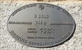
 view gallery view galleryW7.1 km |  N 42º 18’ 25,9’’ W 7º 05’ 57,9’’ - O Bolo, Ourense, España N 42º 18’ 25,9’’ W 7º 05’ 57,9’’ - O Bolo, Ourense, España
in Permanent Geographic Coordinates Punto de referencia en la fachada de la Casa Consistorial con Coordenadas Geográficas Permanentes grabadas // Benchmark on the facade of the Town Hall with Permanent Geographic Coordinates engraved posted by: xeocach location: Galicia, Spain date approved: 12/30/2022 last visited: never |
 view gallery view gallery S7.1 km S7.1 km
| 874m - A Veiga, Ourense, España in Elevation Signs Elevación sobre el nivel medio del Mediterráneo en Alicante // Elevation above the mean level of the Mediterranean Sea in Alicante posted by: xeocach location: Galicia, Spain date approved: 04/12/2023 last visited: never |
 view gallery view galleryS7.1 km | N42º 15’ 00,2’’ W7º 01’ 34,0’’ - A Veiga, Ourense, España in Permanent Geographic Coordinates Marca de nivel en la fachada de la Casa Consistorial con Coordenadas Geográficas Permanentes grabadas // Level mark on the facade of the Town Hall with Permanent Geographic Coordinates posted by: xeocach location: Galicia, Spain date approved: 04/21/2023 last visited: never |
 view gallery view galleryS7.1 km | A Veiga - Ourense, España in Vértices Geodésicos Punto de referencia en la fachada de la Casa Consistorial con Coordenadas Geográficas Permanentes grabadas // Benchmark on the facade of the Town Hall with Permanent Geographic Coordinates engraved posted by: xeocach location: Galicia, Spain date approved: 04/19/2023 last visited: never |
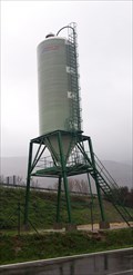
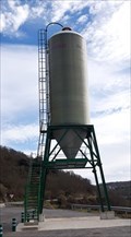 view gallery view galleryW10 km |  OU-533 Km34 – O Bolo, Ourense, España OU-533 Km34 – O Bolo, Ourense, España
in Solitary Silos Silo de vialidad invernal // Winter road silo posted by: xeocach location: Galicia, Spain date approved: 03/27/2023 last visited: never |
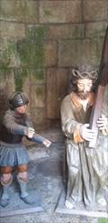 view gallery view galleryW10.5 km |  Via Crucis das Ermitas - O Bolo, Ourense, España Via Crucis das Ermitas - O Bolo, Ourense, España
in Outdoor Stations of the Cross Vía Crucis del siglo XVIII, con imágenes de talla popular // Way of the Cross from the 18th century, with popular carving images posted by: xeocach location: Galicia, Spain date approved: 03/28/2023 last visited: never |
 view gallery view galleryW10.5 km |  Cruceiro das Ermitas - O Bolo, Ourense, España Cruceiro das Ermitas - O Bolo, Ourense, España
in Churchyard Crosses Cruz situada en el centro del atrio del Santuario // Cross located in the center of the atrium of the Sanctuary posted by: xeocach location: Galicia, Spain date approved: 04/01/2023 last visited: never |
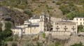
 view gallery view galleryW10.5 km |  Santuario das Ermitas - O Bolo, Ourense, España Santuario das Ermitas - O Bolo, Ourense, España
in Baroque Architecture Templo católico de los siglos XVII-XVIII // Catholic temple from the XVII-XVIII centuries, BIC since 2006. posted by: xeocach location: Galicia, Spain date approved: 11/08/2022 last visited: never |
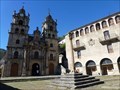 view gallery view galleryW10.5 km |  Santuario das Ermitas - O Bolo, Ourense, España Santuario das Ermitas - O Bolo, Ourense, España
in Wikipedia Entries Templo católico de los siglos XVII-XVIII // Catholic temple from the XVII-XVIII centuries, BIC since 2006. posted by: xeocach location: Galicia, Spain date approved: 11/07/2022 last visited: never |
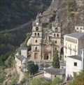 view gallery view galleryW10.5 km |  Santuario das Ermitas - O Bolo, Ourense, España Santuario das Ermitas - O Bolo, Ourense, España
in This Old Church Templo católico de los siglos XVII-XVIII // Catholic temple from the XVII-XVIII centuries, BIC since 2006. posted by: xeocach location: Galicia, Spain date approved: 11/07/2022 last visited: never |
 view gallery view galleryW10.5 km |  Santuario das Ermitas - O Bolo, Ourense, España Santuario das Ermitas - O Bolo, Ourense, España
in Official Local Tourism Attractions Templo católico de los siglos XVII-XVIII // Catholic temple from the XVII-XVIII centuries, BIC since 2006. posted by: xeocach location: Galicia, Spain date approved: 11/07/2022 last visited: never |
 view gallery view galleryW10.5 km | Santuario da Nosa Señora das Ermitas - O Bolo, Ourense, España in Roman Catholic Churches Templo católico de los siglos XVII-XVIII // Catholic temple from the XVII-XVIII centuries, BIC since 2006. posted by: xeocach location: Galicia, Spain date approved: 11/09/2022 last visited: never |
 view gallery view galleryW10.5 km |  Santuario da Nosa Señora das Ermitas - O Bolo, Ourense, España Santuario da Nosa Señora das Ermitas - O Bolo, Ourense, España
in Spanish Heritage Templo católico de los siglos XVII-XVIII // Catholic temple from the XVII-XVIII centuries, BIC since 2006. posted by: xeocach location: Galicia, Spain date approved: 11/08/2022 last visited: never |
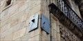 view gallery view galleryW10.5 km |  Santuario das Ermitas - O Bolo, Ourense, España Santuario das Ermitas - O Bolo, Ourense, España
in Sundials Dos relojes de sol haciendo esquina // Two sundials on the corner posted by: xeocach location: Galicia, Spain date approved: 03/26/2023 last visited: never |
 view gallery view gallery N11.1 km N11.1 km
|  Pasarela de Penouta - Vilamartín de Valdeorras, Ourense, España Pasarela de Penouta - Vilamartín de Valdeorras, Ourense, España
in Pedestrian Suspension Bridges Pasarela peatonal sobre el río Sil // Pedestrian footbridge over the river Sil posted by: xeocach location: Galicia, Spain date approved: 03/25/2023 last visited: never |
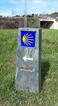
 view gallery view galleryN11.3 km |  Km 207,626 do Camiño de Inverno - Arcos, Vilamartín de Valdeorras, Ourense, España Km 207,626 do Camiño de Inverno - Arcos, Vilamartín de Valdeorras, Ourense, España
in Way of St. James A Catedral compostelá está a 207,626 km // Compostela Cathedral is 207,626 km away posted by: xeocach location: Galicia, Spain date approved: 05/30/2023 last visited: never |
 view gallery view galleryN11.6 km | Silo en A Proba - O Barco de Valdeorras, Ourense, España in Solitary Silos Silo de vialidad invernal // Winter road silo posted by: xeocach location: Galicia, Spain date approved: 01/28/2023 last visited: never |
 view gallery view galleryN11.6 km | Banco Peregrino - O Barco de Valdeorras, Ourense, España in Way of St. James Un repouso antes de retomar o Camiño de Inverno // A rest before resuming the Winter’s Way of St. James posted by: xeocach location: Galicia, Spain date approved: 01/13/2024 last visited: never |
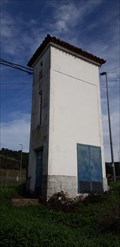 view gallery view galleryN11.6 km |  32CB73 - A Proba, O Barco de Valdeorras, Ourense, España 32CB73 - A Proba, O Barco de Valdeorras, Ourense, España
in Historic Transformer Sub-Stations Buildings Subestación transformadora ubicada en A Proba // Transformer substation tower located in A Proba posted by: xeocach location: Galicia, Spain date approved: 08/04/2023 last visited: never |
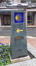
 view gallery view galleryN11.6 km | Km 208,779 do Camiño de Inverno - A Proba, O Barco de Valdeorras, Ourense, España in Way of St. James A Catedral compostelá está a 208,779 km // Compostela Cathedral is 208,779 km away posted by: xeocach location: Galicia, Spain date approved: 07/26/2023 last visited: never |
 view gallery view galleryN11.7 km | Km 212,354 do Camiño de Inverno - O Barco de Valdeorras, Ourense, España in Way of St. James A Catedral compostelá está a 212,354 km // Compostela Cathedral is 212,354 km away posted by: xeocach location: Galicia, Spain date approved: 07/26/2023 last visited: never |
|