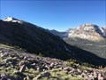
 view gallery view gallery W0 km W0 km
|   Kings Peak, UT Kings Peak, UT
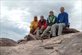
in Mountain Summits Kings Peak is the highest point in Utah at 13,528' (4,128 meter) posted by:  Geepus Geepus location: Utah date approved: 09/07/2005 last visited: 09/03/2006 |
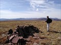
 view gallery view gallery N9.7 km N9.7 km
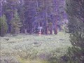
|  Henrys Fork WS Henrys Fork WS
in Weather Stations .
posted by:  caverspencer caverspencer location: Utah date approved: 09/24/2007 last visited: never |
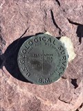
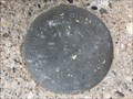
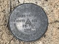
 view gallery view gallery NW14.6 km NW14.6 km
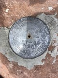
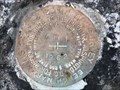
|  ET 59 (LO1109) - Summit County, Utah ET 59 (LO1109) - Summit County, Utah
in U.S. Benchmarks A U.S. Department of Interior Geological Survey disk on the summit of Bald Mountain. posted by: Tom.dog location: Utah date approved: 11/28/2022 last visited: never |
 view gallery view galleryN24.3 km |  Utah Wyoming Crossing North Slope Uintas Utah Wyoming Crossing North Slope Uintas
in Border Crossings Border Crossing on the dirt road leading up to the North Slope of the Uintas posted by: caverspencer location: Utah date approved: 10/01/2007 last visited: 08/10/2013 |
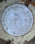
 view gallery view galleryW31.9 km | LA MOTTE PEAK TARGET (LO1137) - Summit County, Utah in U.S. Benchmarks An intersection station centered on the summit of Lamotte Peak. posted by: Tom.dog location: Utah date approved: 11/28/2022 last visited: never |
 view gallery view galleryW32 km | LA MOTTE PEAK (LO1138) - Summit County, Utah in U.S. Benchmarks A USGS benchmark disk from 1897 on the summit of Lamotte Peak. posted by: Tom.dog location: Utah date approved: 11/28/2022 last visited: never |
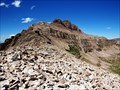
 view gallery view gallery E33.8 km E33.8 km
| Eccentric Peak, Uinta Mountains - UT, USA in Mountain Summits Utah's Eccentric Peak sits on the border of Daggett and Uintah Counties, in the eastern area of the Uinta Mountains. posted by: Chasing Blue Sky location: Utah date approved: 06/14/2011 last visited: 09/23/2008 |
 view gallery view galleryE33.8 km |  Eccentric Peak - High Point in Daggett & Uintah Counties, UT, USA Eccentric Peak - High Point in Daggett & Uintah Counties, UT, USA
in Geographic High Points Utah's Eccentric Peak sits on the border of Daggett and Uintah Counties, representing the high point in each county. posted by: Chasing Blue Sky location: Utah date approved: 06/09/2011 last visited: 09/23/2008 |
 view gallery view galleryE33.8 km | Eccentric Peak, Uinta Mountains, UT, USA in U.S. Benchmarks This Benchmark is on Eccentric Peak, which sits on the border of Daggett and Uintah Counties, representing the high point in each county. posted by: Chasing Blue Sky location: Utah date approved: 06/04/2011 last visited: 09/23/2008 |
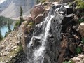 view gallery view galleryW38 km |  Uintas Cache #3: Blue Lake Falls Uintas Cache #3: Blue Lake Falls
in Waterfalls This is the waterfall that comes out of Blue Lake. Blue Lake is just above the waterfalls. posted by: lindon4her location: Utah date approved: 07/02/2012 last visited: never |
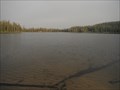 view gallery view galleryW38.9 km |  Uintas Cache #2: Pinto Lake Uintas Cache #2: Pinto Lake
in Natural Lakes This is Pinto Lake. posted by: lindon4her location: Utah date approved: 07/02/2012 last visited: never |
 view gallery view galleryW39.9 km | HAYDEN PEAK TARGET (LO1127) - Summit County, Utah in U.S. Benchmarks The summit of Hayden Peak has been designated as an intersection station in the NGS database. posted by: Tom.dog location: Utah date approved: 12/13/2022 last visited: never |
 view gallery view galleryW40.2 km | F 162 (LO0196) - Summit County, Utah in U.S. Benchmarks A U.S. Bureau of Public Roads benchmark set in the corner of a bridge over the Bear River. posted by: Tom.dog location: Utah date approved: 08/27/2023 last visited: never |
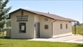
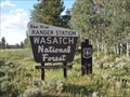 view gallery view galleryW40.4 km |  Bear River Ranger Station - Uinta Mountains, UT Bear River Ranger Station - Uinta Mountains, UT
in Ranger Stations The Bear River Ranger Station is located near the north end of the Mirror Lake Highway in the Uinta Mountains of Utah. posted by: Chasing Blue Sky location: Utah date approved: 08/25/2011 last visited: 08/10/2011 |
 view gallery view galleryW40.6 km | C 161 (LO0195) - Summit County, Utah in U.S. Benchmarks This benchmark can be found just off the side of State Highway 150, near the entrance to the community of Monviso. posted by: Tom.dog location: Utah date approved: 08/27/2023 last visited: never |
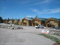 view gallery view galleryNW41.4 km |  The Cabins at Bear River Lodge - Christmas Meadows, UT The Cabins at Bear River Lodge - Christmas Meadows, UT
in Chalet, Cottage, and Cabin Style Lodging The Cabins at Bear River Lodge are located on the north slope of the Uinta Mountains along Highway 50. posted by: Chasing Blue Sky location: Utah date approved: 06/28/2012 last visited: 06/08/2012 |
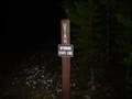
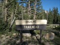
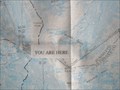 view gallery view galleryW41.8 km |  Highline Trailhead "You Are Here" Uinta Mountains, UT, USA Highline Trailhead "You Are Here" Uinta Mountains, UT, USA
in 'You Are Here' Maps This "You Are Here" is located on the High Uinta Wilderness map, at the trailhead of the Highline Trail. posted by: Chasing Blue Sky location: Utah date approved: 08/26/2011 last visited: 08/10/2011 |
 view gallery view galleryW41.8 km |  Highline Trail - Uinta Mountains - UT, USA Highline Trail - Uinta Mountains - UT, USA
in Long Distance Hiking Trails This is the Western Terminus of the Highline Trail at Mirror Lake Highway in the Uinta Mountains of Utah. posted by: Chasing Blue Sky location: Utah date approved: 08/24/2011 last visited: 08/10/2011 |
 view gallery view galleryW41.8 km |  Highline Trailhead - Highline Trail - Uinta Mountains - UT Highline Trailhead - Highline Trail - Uinta Mountains - UT
in Hiking and walking trailheads This Trailhead is the Western Terminus of the Highline Trail at Mirror Lake Highway in the Uinta Mountains of Utah. posted by: Chasing Blue Sky location: Utah date approved: 08/28/2011 last visited: 08/10/2011 |
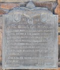
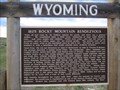 view gallery view gallery NE42.3 km NE42.3 km
|  1825 Rocky Mountain Rendezvous - Burnt Fork, Wyoming 1825 Rocky Mountain Rendezvous - Burnt Fork, Wyoming
in Wyoming Historical Markers The site of one of the first Rocky Mountain Rendezvous was held here in 1825. posted by: Mom the Cook & cashnhubby location: Wyoming date approved: 06/11/2011 last visited: 05/25/2018 |
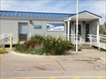 view gallery view galleryN45.7 km |  Robertson Post Office - 82944, Wyoming Robertson Post Office - 82944, Wyoming
in U.S. Post Offices Robertson, Wyoming Post Office posted by: uinta dawn location: Wyoming date approved: 08/25/2013 last visited: never |
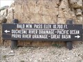 view gallery view galleryW45.7 km |  Bald Mountain Pass Bald Mountain Pass
in Elevation Signs Bald Mountain Pass is located in the Uinta Mountains along Highway 150, also known as the Mirror Lake Highway. posted by: Chasing Blue Sky location: Utah date approved: 04/10/2011 last visited: 08/14/2010 |
 view gallery view galleryNE47.3 km | 23 TWH - Sweetwater County, Wyoming in U.S. Benchmarks A U.S. Department of Interior Geological Survey benchmark on the east side of McKinnon Road (County Road 1), just to the north of Henrys Fork. posted by: Tom.dog location: Wyoming date approved: 06/11/2023 last visited: never |
 view gallery view gallery SE47.8 km SE47.8 km
| Neola, Utah 84053 in U.S. Post Offices This Post Office is located at 9086 N 2000 West in Neola, Utah. posted by: brwhiz location: Utah date approved: 07/15/2013 last visited: never |
 view gallery view gallerySE47.8 km |  First White Settlers in Neola First White Settlers in Neola
in First of its Kind The first white settlers came to Neola in 1906. posted by: brwhiz location: Utah date approved: 09/07/2013 last visited: never |
|