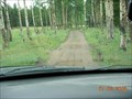
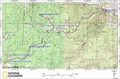
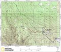
 view gallery view gallery SW6.4 km SW6.4 km
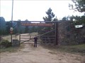
|   Monument Gulch Trail Monument Gulch Trail
in Offroad Trails Monument Gulch Trailhead posted by:  KingJR KingJR location: Colorado date approved: 01/17/2006 last visited: never |
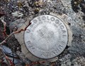
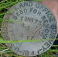 view gallery view gallery S9.2 km S9.2 km
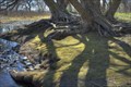
|  Greer Land Office Survey Disk Greer Land Office Survey Disk
in U.S. Benchmarks US General Land Office Survey Disk, stamped 1961 posted by: KingJR location: Colorado date approved: 08/06/2006 last visited: never |
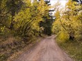 view gallery view gallery E9.3 km E9.3 km
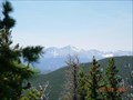
| Old Flowers Road in Offroad Trails Old Flowers Road - Scenic area posted by: KingJR location: Colorado date approved: 01/17/2006 last visited: 08/24/2009 |
 view gallery view gallery NE10.3 km NE10.3 km
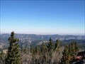
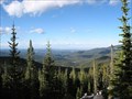
|  Youngs Gulch Youngs Gulch
in Scenic Hikes A nice hike that overlooks the stove prarie road when you reach the summit. posted by: KingJR location: Colorado date approved: 07/03/2007 last visited: 09/30/2011 |
 view gallery view gallery N11.1 km N11.1 km
|  Ben Delatour Scout Ranch Ben Delatour Scout Ranch
in Boy Scout Camps BDSR offers Rocky Mountain camping Adventure on 3400 acres northwest of Fort Collins, CO. posted by:  Cuautemoc Cuautemoc location: Colorado date approved: 01/07/2006 last visited: 07/27/2012 |
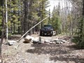
 view gallery view galleryS12.2 km | Crystal Mountain 4x4 area in Offroad Trails This is the crystal mountain 4x4 area. posted by: KingJR location: Colorado date approved: 01/17/2006 last visited: never |
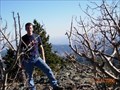 view gallery view galleryS12.6 km |  Crystal Mountain Crystal Mountain
in Mountain Summits Summit of Crystal Mountain, in Buckhorn Canyon - Larimer County, CO. posted by: KingJR location: Colorado date approved: 11/24/2005 last visited: never |
 view gallery view gallerySW12.9 km | Trail 234 - Pingree Park Area in Offroad Trails Un-named trail #234 near Pingree Park Colorado posted by: KingJR location: Colorado date approved: 01/01/2016 last visited: never |
 view gallery view gallery SE12.9 km SE12.9 km
| Moody Hill 4x4 area in Offroad Trails Moody hill 4x4 area posted by: KingJR location: Colorado date approved: 01/17/2006 last visited: 06/28/2012 |
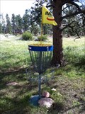 view gallery view galleryN13 km |  Sundance Trail Ranch DGC - Red Feather Lakes, CO Sundance Trail Ranch DGC - Red Feather Lakes, CO
in Disc Golf Courses This disc golf course is located on a dude ranch, over 8,000 feet high on the Colorado Rockies east of Fort Collins. posted by: DougK location: Colorado date approved: 09/03/2011 last visited: never |
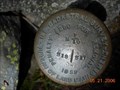
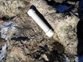
 S15 km | Crystal Mountain unknown U.S.G.S. Benchmark in U.S. Benchmarks Stumbled upon this benchmark while ATVing Crystal Mountain back in August. posted by: KingJR location: Colorado date approved: 11/25/2005 last visited: never |
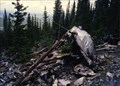 view gallery view gallery W15.3 km W15.3 km
|  Crown Point B-17 Crash Crown Point B-17 Crash
in Plane Crash Sites Wreckage of the 1944 "Crown Point" area B-17. posted by: KingJR location: Colorado date approved: 11/26/2005 last visited: 08/09/2014 |
 view gallery view gallerySW15.3 km | Beaver Creak BLM Cadastral Survey Disk in U.S. Benchmarks BLM Cadastral Survey Disk. posted by: KingJR location: Colorado date approved: 05/21/2006 last visited: never |
 view gallery view gallerySW15.6 km | B17 near Pingree Park, CO in Plane Crash Sites Boeing B17 Flying Fortress that crashed October 19, 1943. posted by: supradave location: Colorado date approved: 10/24/2005 last visited: 07/13/2006 |
 view gallery view galleryE19.2 km | ") GeoCache La Poudre GeoCache La Poudre
in Waymark Tours (WayTours) GeoCache La Poudre is a virtual geocache course along the Cache La Poudre River sponsored by the City of Fort Collins Natural Areas Program. Answer 15+ questions and turn in the brochure (web address below) to be entered into a prize drawing. posted by: geocachelapoudre location: Colorado date approved: 08/04/2009 last visited: never |
 view gallery view galleryS19.2 km | Bulwark Ridge Trail in Scenic Hikes A wonderful hike on top of Bulwark Ridge that takes you to the summit of South Signal Mountain. posted by: KingJR location: Colorado date approved: 07/03/2007 last visited: 05/11/2010 |
 view gallery view galleryS20.3 km | Storm Mountain Cadastral Survery disk in U.S. Benchmarks Cadastral Survey Disk near Storm Mountain Summit posted by: KingJR location: Colorado date approved: 11/26/2005 last visited: never |
 view gallery view galleryS20.4 km | Storm Mountain Trail in Offroad Trails Storm Mountain trail area posted by: KingJR location: Colorado date approved: 01/17/2006 last visited: never |
 view gallery view galleryS24.1 km | Rocky Mountain National Park Sheep Mountain 9796 in U.S. Benchmarks At the top of Sheep Mountain Peak 9796 in Rocky Mountain National Park posted by: AlanC location: Colorado date approved: 10/24/2010 last visited: never |
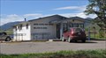 view gallery view galleryE24.1 km |  Bellvue, Colorado 80512 Bellvue, Colorado 80512
in U.S. Post Offices This Post Office is located at 5301 W County Road 52 East in Bellvue, Colorado. posted by: brwhiz location: Colorado date approved: 05/09/2012 last visited: never |
 view gallery view galleryS24.5 km |  Crosier Mountain Summit Register Crosier Mountain Summit Register
in Summit Registers The Croiser Mountain Summit Register can be found at 9,250ft above sea level, after a 4 mile hike in. posted by: Team Laxson location: Colorado date approved: 11/16/2008 last visited: 05/11/2010 |
S24.5 km | Crosier Mountain in Mountain Summits One of the small summits in this part of CO, but the views to the East and West are awesome. posted by: Tahosa and Sons location: Colorado date approved: 11/07/2005 last visited: 06/08/2008 |
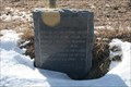 view gallery view galleryE24.8 km |  Cache La Poudre Cache La Poudre
in Colorado Historical Markers Location where trappers cached powder giving the Cache La Poudre river its name. posted by: markdj location: Colorado date approved: 01/20/2008 last visited: 10/14/2019 |
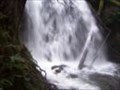 view gallery view galleryS25.1 km |  Bridal Veil Falls Bridal Veil Falls
in Waterfalls This is a nice hike, seeing several smaller step type falls, ends at a nice curtain cascade, hence, veil. posted by: sewnsew location: Colorado date approved: 06/19/2006 last visited: 05/31/2010 |
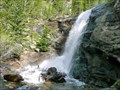 view gallery view galleryS25.1 km | Bridal Veil Falls in Scenic Hikes A beautiful walk through Colorado's colorful Rocky Mountain National Park. This 3 mile hike will take you through Aspen, Ponderosa Pine, and ending with a 20 foot waterfall of crystal clear mountain water. posted by: Team Laxson location: Colorado date approved: 05/28/2010 last visited: 05/31/2010 |
|