 view gallery view gallery NE6.6 km NE6.6 km
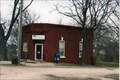
|   Humphreys, Missouri Humphreys, Missouri
in Wikipedia Entries This is really a small town. posted by:  YoSam. YoSam. location: Missouri date approved: 02/15/2016 last visited: never |
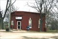 view gallery view galleryNE6.6 km |  Humphreys, MO - 64646 Humphreys, MO - 64646
in U.S. Post Offices Very small town. Once had a brick building down town, but only the foundations remain today. posted by: YoSam. location: Missouri date approved: 08/24/2010 last visited: never |
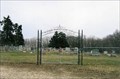
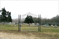 view gallery view gallery N11.3 km N11.3 km
|  Camp Ground Cemetery ~ Osgood, MO Camp Ground Cemetery ~ Osgood, MO
in Worldwide Cemeteries Even though the date on the wrought iron sign above the gate says 1853, I found one stone dated 1846 and another dated 1837. posted by: YoSam. location: Missouri date approved: 08/04/2010 last visited: never |
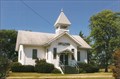
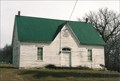 view gallery view galleryN11.3 km |  Camp Ground Church ~ Sullivan County, MO Camp Ground Church ~ Sullivan County, MO
in This Old Church Structurally the! church building has been unaltered since its construction in 1901 posted by: YoSam. location: Missouri date approved: 02/15/2016 last visited: never |
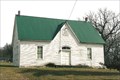 view gallery view galleryN11.3 km | Camp Ground Church ~ Sullivan County, MO in Country Churches Started by the Methodist, now and independent. posted by: YoSam. location: Missouri date approved: 08/04/2010 last visited: never |
 view gallery view galleryN11.3 km | Camp Ground Church and Cemetery - Milan, MO in Wikipedia Entries Land was cleared for a very popular wagon yard on the pioneer trail that passed this way, then became a Christian Camp Ground. posted by: YoSam. location: Missouri date approved: 12/19/2019 last visited: never |
 view gallery view galleryN11.3 km |  Camp Ground Church and Cemetery - Milan, MO Camp Ground Church and Cemetery - Milan, MO
in U.S. National Register of Historic Places Land was cleared for a very popular wagon yard on the pioneer trail that passed this way, then became a Christian Camp Ground. posted by: YoSam. location: Missouri date approved: 08/04/2010 last visited: never |
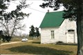 view gallery view galleryN11.3 km |  Camp Ground Church & Cemetery ~ Osgood, MO Camp Ground Church & Cemetery ~ Osgood, MO
in Churchyard Cemeteries A wagon yard in the early 1800s, the Methodist and Presbyterian made cemetery formal. Still in use. posted by: YoSam. location: Missouri date approved: 08/04/2010 last visited: never |
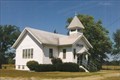
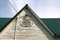 view gallery view galleryN11.3 km |  1901 - Camp Ground Church ~ Osgood, MO 1901 - Camp Ground Church ~ Osgood, MO
in Dated Buildings and Cornerstones Built in 1901 to keep alive a church at the old cemetery and meeting ground. posted by: YoSam. location: Missouri date approved: 08/04/2010 last visited: never |
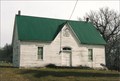 view gallery view galleryN11.3 km |  Camp Ground Chapel - Sullivan County, MO Camp Ground Chapel - Sullivan County, MO
in Cemetery Chapels "Today Camp Ground Church is still used for annual meetings, special occasions, and as a burial grounds and has an active and interested constituency." ~ NRHP posted by: YoSam. location: Missouri date approved: 08/14/2017 last visited: never |
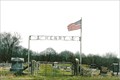
 view gallery view galleryN11.3 km |  Camp Ground Cemetery Arch - Osgood, MO Camp Ground Cemetery Arch - Osgood, MO
in Freestanding Arches The Camp Ground consists of a cemetery of approximately 400 grave sites, a church structure, and surrounding meadow. The grave sites are encircled by a four foot wire mesh fence separating the church structure on its one acre tract of land posted by: YoSam. location: Missouri date approved: 12/15/2013 last visited: never |
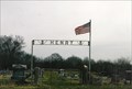
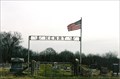
 view gallery view gallery E15.3 km E15.3 km
| Henry Cemetery - Reger, MO in U.S. National Register of Historic Places Named after O. M. Reger, 1881. Before that it was called Elmore. posted by: YoSam. location: Missouri date approved: 08/16/2010 last visited: never |
 view gallery view galleryE15.3 km | Henry Cemetery - Reger, MO in Wikipedia Entries The town was named for O.M. Reger in 1881, but existed before that and was called Elmore... posted by: YoSam. location: Missouri date approved: 12/16/2019 last visited: never |
 view gallery view galleryE15.3 km | Henry Cemetery ~ Reger, MO in Worldwide Cemeteries The town was named for O.M. Reger in 1881, but existed nbefore that and was called Elmore posted by: YoSam. location: Missouri date approved: 08/18/2010 last visited: never |
 view gallery view galleryE15.3 km | Henry Cemetery - Reger, MO in Freestanding Arches This cemetery is also listed on the National Register of Historic Places. posted by: YoSam. location: Missouri date approved: 12/10/2013 last visited: never |
 view gallery view gallery SW19 km SW19 km
| Liberty Chapel Christian Church - Grundy County, MO in Country Churches Way out south of Trenton, about 5 miles, or north of Farmersville, about 5 miles. posted by: YoSam. location: Missouri date approved: 10/31/2013 last visited: never |
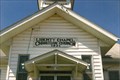 view gallery view gallerySW19 km | 1921 - Liberty Chapel Christian Church - Grundy County, MO in Dated Buildings and Cornerstones Lonely church, about 5 miles S. of Trenton, and about 5 miles N. of Farmersville. posted by: YoSam. location: Missouri date approved: 10/09/2013 last visited: never |
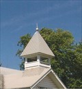 view gallery view gallerySW19 km |  Liberty Chapel Christian Church Bell Tower - S. of Trenton, MO Liberty Chapel Christian Church Bell Tower - S. of Trenton, MO
in Bell Towers Semi-Gothic roof on bell tower... posted by: YoSam. location: Missouri date approved: 01/11/2020 last visited: never |
 view gallery view gallerySW19 km |  Liberty Chapel Christian Church - S. of Trenton, MO Liberty Chapel Christian Church - S. of Trenton, MO
in Religious Buildings Multifarious Gothic roof on bell tower... posted by: YoSam. location: Missouri date approved: 01/11/2020 last visited: never |
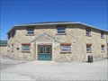
 view gallery view gallery W19.6 km W19.6 km
|  WPA Stock Barn and Pavilion - Trenton, Missouri WPA Stock Barn and Pavilion - Trenton, Missouri
in WPA Projects Stock barn and pavilion constructed by the WPA in Trenton, Missouri. posted by:  BruceS BruceS location: Missouri date approved: 05/05/2013 last visited: never |
 view gallery view galleryW19.6 km | WPA Stock Barn and Pavilion - Trenton, Missouri in U.S. National Register of Historic Places Stock barn and pavilion constructed by the WPA in Trenton, Missouri. posted by: BruceS location: Missouri date approved: 05/05/2013 last visited: never |
 view gallery view gallerySW20 km | 64635 - Chula, MO in U.S. Post Offices Small town with very active farming and grain elevators. posted by: YoSam. location: Missouri date approved: 10/13/2013 last visited: never |
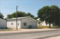 view gallery view gallerySW20 km | Chula, Missouri in Wikipedia Entries Very small town, probably only still existing because of a very active farmers Co-op. posted by: YoSam. location: Missouri date approved: 04/10/2016 last visited: never |
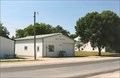 view gallery view gallerySW20 km |  Chula, MO Chula, MO
in City and Town Halls Very small town, probably only still existing because of a very active farmers Co-op. posted by: YoSam. location: Missouri date approved: 10/09/2013 last visited: never |
 view gallery view galleryW20.3 km | Trenton High School - Trenton, Missouri in U.S. National Register of Historic Places Historic former high school now apartment building in Trenton, Missouri. posted by: BruceS location: Missouri date approved: 05/05/2013 last visited: never |
|