 view gallery view gallery N2.1 km N2.1 km
|   Hyattstown Uninvited Guests - Clarksburg, MD Hyattstown Uninvited Guests - Clarksburg, MD
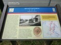
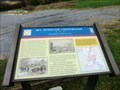
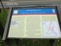
in Civil War Discovery Trail Sites The roadside village of Hyattstown became the front line when Confederate cavalry stationed to the north in Urbana clashed with Union cavalry reconnoitering from Clarksburg to the south. posted by:  Don.Morfe Don.Morfe location: Maryland date approved: 03/27/2020 last visited: 10/08/2021 |
 view gallery view galleryN2.1 km | Hyattstown Uninvited Guests - Hyattstown MD in U.S. Civil War Sites The roadside village of Hyattstown became the front line when Confederate cavalry stationed to the north in Urbana clashed with Union cavalry reconnoitering from Clarksburg to the south on the evening of September 8, 1862. posted by: Don.Morfe location: Maryland date approved: 03/29/2023 last visited: 04/02/2023 |
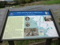
 view gallery view galleryN2.1 km |  Skirmish at Hyattstown - Hyattstown MD Skirmish at Hyattstown - Hyattstown MD
in Battlefields The roadside village of Hyattstown became the front line when Confederate cavalry stationed to the north in Urbana clashed with Union cavalry reconnoitering from Clarksburg to the south on the evening of September 8, 1862. posted by: Don.Morfe location: Maryland date approved: 03/29/2023 last visited: 04/02/2023 |
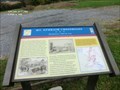
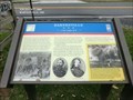
 view gallery view galleryN2.1 km |  Hyattstown - Maryland Hyattstown - Maryland
in People-Named Places Jesse Hyatt founded historic Hyattstown, MD in 1798. In March 1986, Hyattstown was designated a historic district by county elected officials. It has one of the largest groupings of relatively unaltered 19th century buildings in Montgomery County. posted by: Don.Morfe location: Maryland date approved: 03/29/2023 last visited: 04/02/2023 |
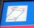
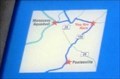
 view gallery view galleryN2.1 km |  You Are Here Maps - Hyattstown Uninvited Guests - Hyattstown MD You Are Here Maps - Hyattstown Uninvited Guests - Hyattstown MD
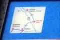
in 'You Are Here' Maps You Are Here map shows that you are at the intersection of Frederick Road (Maryland Route 355) and Hyattstown Mill Road at the entrance to Little Bennett Regional Park at the official address of 25801 Frederick Rd, Clarksburg MD 20871 posted by: Don.Morfe location: Maryland date approved: 03/28/2023 last visited: 04/02/2023 |
 view gallery view gallery SW3.5 km SW3.5 km
| 1862 Antietam Campaign Lee Invades Maryland - Dickerson MD in Civil War Discovery Trail Sites Fresh from victory at the Second Battle of Manassas, Gen. Robert E. Lee’s Army of Northern Virginia crossed the Potomac River on September 4-6, 1862, to bring the Civil War to Northern soil and to recruit sympathetic Marylanders. posted by: Don.Morfe location: Maryland date approved: 03/29/2020 last visited: 10/08/2021 |
 view gallery view gallerySW3.5 km | 1862 Antietam Campaign Lee Invades Maryland- Dickerson MD in U.S. Civil War Sites Fresh from victory at the Second Battle of Manassas, Gen. Robert E. Lee’s Army of Northern Virginia crossed the Potomac River on September 4-6, 1862, to bring the Civil War to Northern soil and to recruit sympathetic Marylanders. posted by: Don.Morfe location: Maryland date approved: 03/28/2023 last visited: 04/02/2023 |
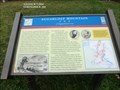
 view gallery view gallerySW3.5 km | Mt. Ephraim Crossroads Sharpshooters Hold the Line - Dickerson, MD in Civil War Discovery Trail Sites You are looking at Sugarloaf Mountain, where the running cavalry fight that began in the late afternoon on September 9, 1862, in Barnesville came to a halt. posted by: Don.Morfe location: Maryland date approved: 03/27/2020 last visited: 10/08/2021 |
 view gallery view gallerySW3.5 km | Mt. Ephraim Crossroads Sharpshooters Hold the Line - Comus MD in U.S. Civil War Sites You are looking at Sugarloaf Mountain, where the running cavalry fight that began in the late afternoon on September 9, 1862, in Barnesville came to a halt. posted by: Don.Morfe location: Maryland date approved: 03/28/2023 last visited: 04/02/2023 |
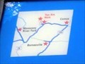
 view gallery view gallerySW3.5 km | Mt. Ephraim Crossroads - Comus MD in 'You Are Here' Maps You Are Hear map shows that you are at the foot of Sugarloaf Mountain on Comus Road. It is located in the rear of a parking lot for the Comus Inn at 23900 Old Hundred Rd, Dickerson MD 20842 posted by: Don.Morfe location: Maryland date approved: 03/28/2023 last visited: 04/02/2023 |
 view gallery view gallerySW3.5 km | Battle at Sugarloaf Mountain-Mt. Ephraim Crossroads Sharpshooters Hold the Line - Comus MD in Battlefields You are looking at Sugarloaf Mountain, where the running cavalry fight that began in the late afternoon on September 9, 1862, in Barnesville came to a halt. posted by: Don.Morfe location: Maryland date approved: 03/29/2023 last visited: 04/02/2023 |
 view gallery view gallery W7.1 km W7.1 km
| Sugarloaf Mountain A Signalman’s Lot - Stronghold MD in Civil War Discovery Trail Sites You are at the foot of Sugarloaf Mountain, where on September 5-6, 1862, Union observers watched the Army of Northern Virginia cross the Potomac River to invade Maryland. posted by: Don.Morfe location: Maryland date approved: 03/22/2020 last visited: 10/08/2021 |
 view gallery view galleryW7.1 km | Sugarloaf Mountain A Signalman’s Lot - Dickerson MD in U.S. Civil War Sites You are at the foot of Sugarloaf Mountain, where on September 5-6, 1862, Union observers watched the Army of Northern Virginia cross the Potomac River to invade Maryland. posted by: Don.Morfe location: Maryland date approved: 03/28/2023 last visited: 04/02/2023 |
 view gallery view galleryW7.1 km | You Are Here Map - Sugarloaf Mountain - Stronghold MD in 'You Are Here' Maps The You Are Here map shows that you are on Comus Road at the foot of Sugarloaf Mountain in Stronghold MD. The formal address is 7901 Comus Road, Dickerson MD 20842. posted by: Don.Morfe location: Maryland date approved: 03/28/2023 last visited: 04/02/2023 |
 view gallery view gallerySW7.4 km | Barnesville “Before night our town changed hands five times!” - Barnesville MD in Civil War Discovery Trail Sites On the evening of September 5, 1862, Gen. Wade Hampton’s and Gen. Fitzhugh Lee’s Confederate cavalry brigades bivouacked around Barnesville. posted by: Don.Morfe location: Maryland date approved: 03/22/2020 last visited: 10/08/2021 |
 view gallery view gallerySW7.4 km | Barnesville “... a bad night of it...” - Barnesville, MD in Civil War Discovery Trail Sites The advance of Union Gen. John F. Reynolds’ I Corps began slogging through Barnesville on the morning of Friday, June 26, 1863, having crossed the Potomac River the afternoon before and camped west of town. posted by: Don.Morfe location: Maryland date approved: 03/22/2020 last visited: 10/08/2021 |
 view gallery view gallerySW7.4 km | Barnesville “… a bad night of it…” - Barnesville MD in U.S. Civil War Sites The advance of Union Gen. John F. Reynolds’ I Corps began slogging through Barnesville on the morning of Friday, June 26, 1863, having crossed the Potomac River the afternoon before and camped west of town. posted by: Don.Morfe location: Maryland date approved: 03/27/2023 last visited: 04/02/2023 |
 view gallery view gallerySW7.4 km | You Are Here Map - Barnesville “… a bad night of it…” - Barnesville MD in 'You Are Here' Maps The You Are Here Map shows that you are at the intersection of Barnesville Road and West Harris Road in Barnesville MD in the parking lot of the St. Mary’s Church. posted by: Don.Morfe location: Maryland date approved: 03/27/2023 last visited: 04/02/2023 |
 view gallery view gallery SE7.7 km SE7.7 km
|  Stan Miller - Damascus, MD Stan Miller - Damascus, MD
in Ghost Bikes Stan was killed in 2010 by a drunk driver while almost home on his bicycle. This memorial is seen along Ridge Road. posted by:  vhasler vhasler location: Maryland date approved: 03/08/2012 last visited: 04/15/2012 |
 view gallery view gallery S7.7 km S7.7 km
|  Black Hill Park - Boyds MD Black Hill Park - Boyds MD
in Nature Centers The Black Hill Nature Center is open year-round and offers exhibits about the flora and fauna of the area. Naturalists also offer seasonal pontoon boat tours and educational programs. posted by: HaricotVert_52 location: Maryland date approved: 09/10/2009 last visited: 09/24/2010 |
 view gallery view gallery E7.7 km E7.7 km
|  Wind Harps - Damascus, MD Wind Harps - Damascus, MD
in Outdoor Wind Harps Set of three harps in a country park while create a sound when the wind blows. posted by: vhasler location: Maryland date approved: 03/05/2012 last visited: 08/04/2018 |
 view gallery view galleryE7.7 km |  Wind Harps - Damascus, MD Wind Harps - Damascus, MD
in Smithsonian Art Inventory Sculptures When the wind blows, these set of three harps are to create a sound. posted by: vhasler location: Maryland date approved: 03/06/2012 last visited: 07/04/2014 |
 view gallery view gallery NW7.7 km NW7.7 km
|  Dunkin' - Fingerboard Rd. - Frederick, MD Dunkin' - Fingerboard Rd. - Frederick, MD
in Dunkin Donuts' Dunkin' store located in Frederick, Maryland. posted by: bobfrapples8 location: Maryland date approved: 08/06/2023 last visited: never |
 view gallery view galleryNW7.7 km |  Dunkin' - Wi-Fi Hotspot - Frederick, MD Dunkin' - Wi-Fi Hotspot - Frederick, MD
in Wi-Fi Hotspots Wi-Fi Hotspot provided by Dunkin' in a combo Dunkin'/Baskin-Robbins in Frederick, Maryland. posted by: bobfrapples8 location: Maryland date approved: 08/06/2023 last visited: never |
 view gallery view gallerySE7.9 km |  Water's Landing Park Tennis Courts - Germantown, MD Water's Landing Park Tennis Courts - Germantown, MD
in Tennis Facilities A small tennis facility in a small DC Suburb. posted by: bluesnote location: Maryland date approved: 01/09/2015 last visited: 01/09/2015 |
|