 view gallery view gallery S36.4 km S36.4 km
|   ORIGIN: Río Segura - Jaen - Andalucía (Spain) ORIGIN: Río Segura - Jaen - Andalucía (Spain)
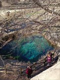
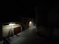
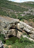
in River Origins, Destinations and Confluences Poza localizada en la falda de un monte rocoso y escarpado, a 1400 metros de altitud en plena Sierra de Segura - Pool located at the foot of a rocky and steep mountain, at 1400 meters of altitude in the Sierra de Segura posted by:  Wizard_Speed_Time Wizard_Speed_Time location: Andalucía, Spain date approved: 02/07/2022 last visited: 02/09/2022 |
 view gallery view gallery SE40.7 km SE40.7 km
|  Mingarnao - Nerpio Mingarnao - Nerpio
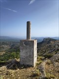
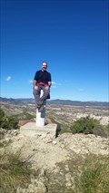
in Vértices Geodésicos Vértice geodésico Mingarnao
En buen estado, al norte de Nerpio posted by: Wizard_Speed_Time location: Castilla-La Mancha, Spain date approved: 11/24/2021 last visited: 11/24/2021 |
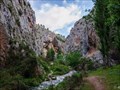 view gallery view gallerySE43.6 km |  Ruta del Zarzalar - Nerpio (Albacete), Castilla-La Mancha, Spain Ruta del Zarzalar - Nerpio (Albacete), Castilla-La Mancha, Spain
in Scenic Hikes Paseo fluvial por el cañón del Río Taibilla tras su paso por el municipio de Nerpio.
---
River walk through the canyon of the Taibilla River after passing through the municipality of Nerpio. posted by: Wizard_Speed_Time location: Castilla-La Mancha, Spain date approved: 12/18/2021 last visited: 04/01/2023 |
 view gallery view gallerySE43.6 km |  Nerpio - Albacete, Spain Nerpio - Albacete, Spain
in Wikipedia Entries Nerpio es un municipio español situado al sureste de la península ibérica, en la provincia de Albacete, dentro de la comunidad autónoma de Castilla-La Mancha posted by: Wizard_Speed_Time location: Castilla-La Mancha, Spain date approved: 06/16/2021 last visited: 11/24/2021 |
 view gallery view gallerySE43.8 km |  ISS Sighting 14 May 2021 - El Reno, OK; Holland, MI; Brunete, Spain (Site 2) ISS Sighting 14 May 2021 - El Reno, OK; Holland, MI; Brunete, Spain (Site 2)
in International Space Station Sightings Late evening 14 May 2021 ISS pass seen by Vulture1957 in El Reno OK, TheHostas in Holland MI, and Picarax in Brunete, Spain. Three countries on two continents, 5439 miles of ISS travel in 19 minutes, 2 seconds of ISS flight. posted by: Wizard_Speed_Time location: Castilla-La Mancha, Spain date approved: 06/15/2021 last visited: 05/14/2021 |
 view gallery view gallerySE43.8 km | ISS Sighting Point 2 - A Valenzá, Barbadás, Ourense, Galicia, España - Nerpio, Albacete, Castilla la Mancha, España in International Space Station Sightings Space Brotherhood inside Spanish country between Ariberna and Picarax February 3rd. posted by: Wizard_Speed_Time location: Castilla-La Mancha, Spain date approved: 02/09/2022 last visited: 02/10/2022 |
 view gallery view gallerySE43.8 km |  Picarax - Nerpio, Albacete (Castilla-La Mancha) - Spain Picarax - Nerpio, Albacete (Castilla-La Mancha) - Spain
in Geocaching Tour Guides Mi nombre es Lucas (picarax) y estaré encantado de mostraros Nerpio a través de Geocaching o Waymarking. My name is Lucas (picarax) and I'm happy to show you around some cool parts of Nerpio through Geocaching or Waymarking Whatsapp: +34 652 54 22 85 posted by: Wizard_Speed_Time location: Castilla-La Mancha, Spain date approved: 01/12/2022 last visited: 11/17/2022 |
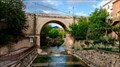 view gallery view gallerySE43.8 km |  Puente de Nerpio - Albacete, Castilla-La Mancha, Spain Puente de Nerpio - Albacete, Castilla-La Mancha, Spain
in Stone Bridges Puente de Piedra de Nerpio del siglo - Nerpio stone bridge form XIX posted by: Wizard_Speed_Time location: Castilla-La Mancha, Spain date approved: 12/18/2021 last visited: 12/20/2021 |
 view gallery view gallery E54.1 km E54.1 km
| San Blas - Elche de la Sierra in Vértices Geodésicos Vértice geodésico San Blas. En buen estado, al sur de Elche de la Sierra posted by: Wizard_Speed_Time location: Castilla-La Mancha, Spain date approved: 11/24/2021 last visited: 11/24/2021 |
 view gallery view galleryS56.8 km | Empanada (Cazorla-Jaén) in Vértices Geodésicos Empanada (2107 mts). Sierra de Cazorla y Castril, límite de provincia entre Jaén y Granda. posted by:  PepeLuichi PepeLuichi location: Spain date approved: 02/29/2008 last visited: 11/11/2007 |
 view gallery view gallery W61.6 km W61.6 km
|  Cascada de la Cimbarra Cascada de la Cimbarra
in Waterfalls Paraje Natural "Cascada de la Cimbarra" en Sierra Morena posted by: monticola location: Andalucía, Spain date approved: 05/07/2008 last visited: 04/15/2022 |
 view gallery view gallery NE62.9 km NE62.9 km
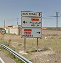
|  San Pedro - Albacete, Castilla-La Mancha (Spain) San Pedro - Albacete, Castilla-La Mancha (Spain)
in Names From the Bible Pueblo llamado San Pedro, en Albacete, Castilla-La Mancha - Town called San Pedro, in Albacete, Castilla-La Mancha posted by: Wizard_Speed_Time location: Castilla-La Mancha, Spain date approved: 01/12/2022 last visited: 01/12/2022 |
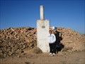
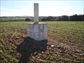 view gallery view gallery N73.2 km N73.2 km
| Santo Domingo (Lezuza-Albacete) in Vértices Geodésicos Situado en el punto más elevado del cerro de Santo Domingo o del Santo, en tierra de labor y a unos 450 m. al S.E. de una antena repetidora de televisión. posted by: Kini025 location: Castilla-La Mancha, Spain date approved: 11/24/2009 last visited: never |
 view gallery view galleryW74.2 km |  Restaurante Santa Cruz - Mudela, Ciudad Real, Castilla La Mancha, España Restaurante Santa Cruz - Mudela, Ciudad Real, Castilla La Mancha, España
in Photos Then and Now Restaurant niw and in 1967 posted by: Ariberna location: Castilla-La Mancha, Spain date approved: 06/04/2023 last visited: never |
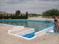 view gallery view galleryS77.9 km |  Manantial Publico de Fuencaliente Agus Continental, Spain Manantial Publico de Fuencaliente Agus Continental, Spain
in Public Swimming Pools The ultimate in cool pools........fed by underground springs! posted by: BarbershopDru location: Spain date approved: 07/26/2008 last visited: never |
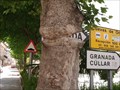 view gallery view galleryS79 km |  "Granada" sign omnivorous tree - Orce, Spain "Granada" sign omnivorous tree - Orce, Spain
in Omnivorous Trees You used to be able to tell which direction it was to Granada! posted by: BarbershopDru location: Andalucía, Spain date approved: 12/14/2008 last visited: 04/14/2017 |
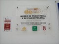 view gallery view galleryS79 km |  Museo de Prehistoria Y Paleontologia - Orce, Spain Museo de Prehistoria Y Paleontologia - Orce, Spain
in Science Museums A museum set up by Jose Gibert to house some of his fossils. posted by: BarbershopDru location: Spain date approved: 08/16/2008 last visited: never |
 view gallery view galleryNE79.7 km | Esperil (Barrax-Albacete) in Vértices Geodésicos Situado en el punto más elevado de la Cuesta de la Yegua, en terreno de monte bajo. posted by: Kini025 location: Castilla-La Mancha, Spain date approved: 11/24/2009 last visited: 02/26/2012 |
 view gallery view galleryS79.7 km |  Cueva Casa de Gilbert, Spain Cueva Casa de Gilbert, Spain
in Earth Homes I had the pleasure of visiting this ultimate Earth Home recently while in Spain. posted by: BarbershopDru location: Andalucía, Spain date approved: 07/23/2008 last visited: never |
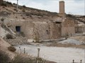
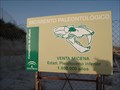 view gallery view galleryS81 km |  Yacimiento Paleontologico, Venta Micena, Spain Yacimiento Paleontologico, Venta Micena, Spain
in Places of Geologic Significance This area is of geological significance due to the paleontology of the Orce region. posted by: BarbershopDru location: Spain date approved: 07/24/2008 last visited: never |
 view gallery view galleryW83.8 km |  La Carolina - Jaén, España La Carolina - Jaén, España
in City Names in Giant Letters Letras gigantes en una rotonda // Giant letters on a roundabout posted by: xeocach location: Andalucía, Spain date approved: 09/25/2023 last visited: never |
 view gallery view gallerySE84.3 km | Gallardo (Sierra de Maria-Almeria) in Vértices Geodésicos Situado en el paraje Pozo Gallardo, en el alto de Los Rasicos, en terreno de pinos de repoblación forestal. posted by: Kini025 location: Andalucía, Spain date approved: 04/20/2010 last visited: never |
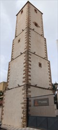 view gallery view galleryW84.3 km |  Torre de Perdigones - La Carolina, Jaén, España Torre de Perdigones - La Carolina, Jaén, España
in Shot Towers Ubicada en la Calle Ondeanos número 26 /// Located on Calle Ondeanos number 26 posted by: xeocach location: Andalucía, Spain date approved: 09/25/2023 last visited: never |
 view gallery view galleryNE85.6 km | Pedrizo-(Albacete) in Vértices Geodésicos Situado junto a un majano, al O. del Camino del Cuarto del Moral a Casa Caballos y en la prolongación de un lindero. El paraje recibe el nombre de La Tiesa posted by: Kini025 location: Castilla-La Mancha, Spain date approved: 11/23/2009 last visited: never |
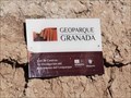 view gallery view galleryS90.8 km | Geoparque de Granada - Fonelas, Granada, España in Wikipedia Entries El Geoparque Mundial de la Unesco de Granada es un espacio de la red de geoparques de la Unesco, situado en el sudoeste de España, en la provincia de Granada, con una extensión de 4.722 km² a lo largo de la comarcas de Baza, Guadix y Huéscar. posted by: GURUGU location: Andalucía, Spain date approved: 11/10/2023 last visited: 12/26/2023 |
|