 view gallery view gallery W0.6 km W0.6 km
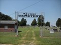
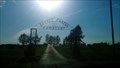
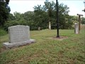
|   Maumee Cemetery - Gibson County, IN, USA Maumee Cemetery - Gibson County, IN, USA
in Worldwide Cemeteries Maumee Cemetery is on CR 1000 West at the intersection of Hwy 165. posted by:  WayBetterFinder WayBetterFinder location: Indiana date approved: 08/12/2010 last visited: 09/25/2014 |
 view gallery view gallery E4.5 km E4.5 km
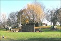
|  Montgomery Park - Gibson County, Owensville, IN Montgomery Park - Gibson County, Owensville, IN
in Municipal Parks and Plazas Montgomery Park is a municipal park on the west side of Owensville, IN. posted by: WayBetterFinder location: Indiana date approved: 08/21/2010 last visited: 08/16/2018 |
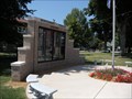 view gallery view galleryE4.7 km |  War Memorial at the Town Square - Owensville, IN War Memorial at the Town Square - Owensville, IN
in Non-Specific Veteran Memorials A War Memorial of the people from Owensville and the surrounding Mongomery Township area commemorating the those who fought and died in wars from the Spanish American to the Persian Gulf wars. posted by: WayBetterFinder location: Indiana date approved: 08/11/2010 last visited: 08/11/2010 |
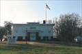
 view gallery view galleryE4.8 km |  Police Department - Owensville, IN Police Department - Owensville, IN
in Police Stations The Owensville, IN police department is located in the Town Hall building at 108 W. Brummitt Street, Owensville, IN 47665. posted by: WayBetterFinder location: Indiana date approved: 08/11/2010 last visited: 12/08/2010 |
 view gallery view galleryE4.8 km |  Owensville, IN Owensville, IN
in City and Town Halls The Town Hall of Owensville, IN is located in the northeast corner of the town square on W. Brummitt Street. posted by: WayBetterFinder location: Indiana date approved: 08/21/2010 last visited: 08/21/2010 |
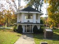
 view gallery view galleryE4.8 km |  Carnegie Library Building - Owensville, IN Carnegie Library Building - Owensville, IN
in Carnegie Library Buildings A Carnegie Library building is at the center of the town square in Owensville, IN. posted by: WayBetterFinder location: Indiana date approved: 08/12/2010 last visited: 08/13/2010 |
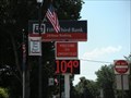 view gallery view galleryE4.8 km |  Fifth Third Bank Time & Temperature - Owensville, IN Fifth Third Bank Time & Temperature - Owensville, IN
in Time and Temperature Signs Time and Temperature sign at the northest corner of the Owensville town square at the corner of W. Brummitt and S. Main. posted by: WayBetterFinder location: Indiana date approved: 08/10/2010 last visited: 12/08/2010 |
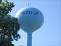 view gallery view galleryE5.1 km |  Water Tower - Owensville, IN Water Tower - Owensville, IN
in Water Towers Water tower located in Owensville, IN (on Water Tower Rd, of course)! posted by: Odyssey Posse location: Indiana date approved: 07/01/2009 last visited: 01/01/2011 |
 view gallery view gallery SE9.3 km SE9.3 km
| Blythe Chapel Cemetery - Owensville, IN in Worldwide Cemeteries Blythe Chapel Cemetery in rural Gibson County posted by:  thegorilla23 thegorilla23 location: Indiana date approved: 05/17/2012 last visited: 06/07/2012 |
 view gallery view gallery S10.5 km S10.5 km
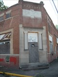
|  Converted Bank - Cynthiana, IN, USA Converted Bank - Cynthiana, IN, USA
in Converted Bank Buildings The converted bank building does not have the old bank name on it anymore. The building is currently empty, although it had been used by another company. posted by: WayBetterFinder location: Indiana date approved: 08/21/2010 last visited: 06/24/2015 |
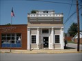 view gallery view galleryS10.6 km | Cynthiana Town Hall - Cynthiana, IN in City and Town Halls The town hall of Cynthiana is the executive offices of the Indiana town of Cynthiana. posted by: WayBetterFinder location: Indiana date approved: 08/21/2010 last visited: 06/24/2015 |
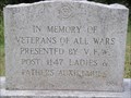
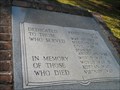 view gallery view galleryS10.6 km |  Cynthiana Veterans Memorial - Cynthiana, IN Cynthiana Veterans Memorial - Cynthiana, IN
in Spanish-American War Memorials Honoring veterans from 9 wars, including the Spanish-American War. posted by: kodiak_62 location: Indiana date approved: 11/17/2008 last visited: 06/24/2015 |
 view gallery view galleryS10.6 km | Cynthiana Veterans Memorial - Cynthiana, IN in Non-Specific Veteran Memorials Honoring veterans from 9 wars. posted by: kodiak_62 location: Indiana date approved: 11/21/2008 last visited: 06/24/2015 |
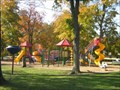 view gallery view galleryS10.6 km |  Cynthiana public playground - Cynthiana, IN Cynthiana public playground - Cynthiana, IN
in Public Playgrounds public playground located in Cynthiana, IN. posted by: kodiak_62 location: Indiana date approved: 11/02/2008 last visited: 06/24/2015 |
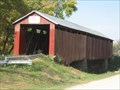 view gallery view galleryW11.9 km |  The Old Red Covered Bridge The Old Red Covered Bridge
in Covered Bridges The Historic Old Red Covered Bridge posted by: kodiak_62 location: Indiana date approved: 11/02/2008 last visited: 04/26/2015 |
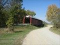 view gallery view galleryW11.9 km |  The Old Red Covered Bridge The Old Red Covered Bridge
in Orphaned Bridges The Historic Old Red Bridge on CR 1675. posted by: kodiak_62 location: Indiana date approved: 11/06/2008 last visited: 04/26/2015 |
 view gallery view gallery NE12.1 km NE12.1 km
| Sand Hill Cemetery - Gibson County, Princeton, IN, USA in Worldwide Cemeteries Sand Hill cemetery is in Gibson County on the edge of Princeton, IN, off W. Broadway (SR 64) a few miles west of the intersection of SR 64 and Hwy 41. posted by: WayBetterFinder location: Indiana date approved: 08/13/2010 last visited: 08/13/2010 |
 view gallery view galleryNE12.1 km | Veterans of All Wars Memorial - Princeton, IN in Non-Specific Veteran Memorials A non-specific veteran memorial by a flag pole in the Sand Hill cemetery in Princeton, IN. posted by: WayBetterFinder location: Indiana date approved: 08/13/2010 last visited: 08/13/2010 |
 view gallery view galleryS12.6 km | Veterans Memorial - Poseyville, IN in Non-Specific Veteran Memorials Large grass area upon entering this small town. posted by: YoSam. location: Indiana date approved: 11/01/2008 last visited: 05/27/2015 |
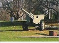 view gallery view galleryS12.6 km |  105 mm M2A1 (M101A1) howitzer ~ Poseyville, IN 105 mm M2A1 (M101A1) howitzer ~ Poseyville, IN
in Static Artillery Displays Located on the corner of the Poseyville Cemetery posted by: YoSam. location: Indiana date approved: 12/16/2014 last visited: 11/10/2016 |
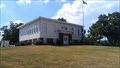 view gallery view galleryNE12.7 km |  Lyles Station Historic School & Museum - Lyles Station, IN Lyles Station Historic School & Museum - Lyles Station, IN
in History Museums Museum to celebrate the history of the Lyles Station African American settlement posted by: thegorilla23 location: Indiana date approved: 07/28/2013 last visited: 08/15/2006 |
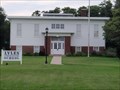 view gallery view galleryNE12.7 km |  Lyles Consolidated School - Gibson County, IN Lyles Consolidated School - Gibson County, IN
in U.S. National Register of Historic Places Lyles Consolidated School (added 1999 - Building - #99001111)
Also known as Lyles Station School
Cty. Rd. 100 N, Lyles Station
Historic Significance: Event
Area of Significance: Education, Black
Period of Significance: 1900-1924, 1925-1949 posted by: Odyssey Posse location: Indiana date approved: 07/23/2009 last visited: 07/20/2013 |
 view gallery view galleryNE12.7 km |  Lyles Consolidated School - Lyles Station, IN Lyles Consolidated School - Lyles Station, IN
in Wikipedia Entries Restored former school building in an African American settlement posted by: thegorilla23 location: Indiana date approved: 07/21/2013 last visited: 08/15/2006 |
 view gallery view galleryNE12.7 km |  A pre-Civil War Haven for Free Blacks - Lyles Station, IN A pre-Civil War Haven for Free Blacks - Lyles Station, IN
in News Article Locations A pre-Civil War haven for free blacks is now honored in the African American Museum posted by: YoSam. location: Indiana date approved: 03/13/2019 last visited: never |
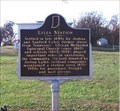 view gallery view galleryNE12.7 km |  Lyles Station Lyles Station
in Indiana Historical Markers Freed Slaves community in western Indiana posted by: YoSam. location: Indiana date approved: 02/12/2007 last visited: 07/20/2013 |
|