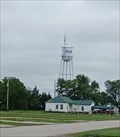
 view gallery view gallery SW11.6 km SW11.6 km
|   Municipal Water Tower - Burns, KS Municipal Water Tower - Burns, KS
in Water Towers This water tower serves Burns, Kansas. posted by:  The Snowdog The Snowdog location: Kansas date approved: 07/27/2021 last visited: never |
 view gallery view gallerySW11.6 km |  Burns Municipal Tank (FJ1442) - Burns, KS Burns Municipal Tank (FJ1442) - Burns, KS
in U.S. Benchmarks This municipal water tower is a NGS benchmark - in Burns, Kansas. posted by: The Snowdog location: Kansas date approved: 07/27/2021 last visited: never |
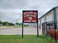 view gallery view gallerySW11.6 km |  Butler Co Fire Dist 10 Burns Fire Butler Co Fire Dist 10 Burns Fire
in Firehouses The Burns County Fire District 10 station is in Burns, Kansas. posted by: The Snowdog location: Kansas date approved: 07/27/2021 last visited: never |
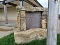 view gallery view gallerySW11.6 km |  Veterans Memorial - Burns, KS Veterans Memorial - Burns, KS
in Non-Specific Veteran Memorials This small veterans memorial names those who fought in three conflicts - in Burns, Kansas. posted by: The Snowdog location: Kansas date approved: 07/27/2021 last visited: never |
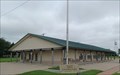 view gallery view gallerySW11.6 km |  Community Center - Burns, KS Community Center - Burns, KS
in Municipal Community Centers The Burns Community Center is on the north edge of town, right across from the Fire Station - in Burns, Kansas. posted by: The Snowdog location: Kansas date approved: 07/28/2021 last visited: never |
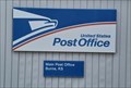 view gallery view gallerySW11.7 km |  Burns, KS 66840 Burns, KS 66840
in U.S. Post Offices This small Post Office serves Burns, Kansas. posted by: The Snowdog location: Kansas date approved: 07/27/2021 last visited: never |
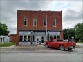 view gallery view gallerySW11.7 km |  Burns, KS Burns, KS
in City and Town Halls City Hall and the Public Library share the same building - in Burns, Kansas. posted by: The Snowdog location: Kansas date approved: 07/28/2021 last visited: never |
 view gallery view gallerySW11.7 km |  Public Library - Burns, KS Public Library - Burns, KS
in Libraries The Burns Public Library is housed in the same building as City Hall - in Burns, Kansas. posted by: The Snowdog location: Kansas date approved: 07/27/2021 last visited: never |
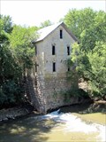 view gallery view gallery N13.2 km N13.2 km
|  Cedar Point Mill - Cedar Point, Kansas Cedar Point Mill - Cedar Point, Kansas
in U.S. National Register of Historic Places Historic former water powered will in the community of Cedar Point, Kansas. posted by:  BruceS BruceS location: Kansas date approved: 05/05/2011 last visited: 05/12/2011 |
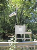 view gallery view gallery NW13.4 km NW13.4 km
|  Cottonwood River Gauge - Cedar Point, Kansas Cottonwood River Gauge - Cedar Point, Kansas
in River Gauges River gauge for the Cottonwood River near Cedar Point, Kansas. posted by: BruceS location: Kansas date approved: 05/05/2011 last visited: never |
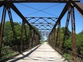 view gallery view galleryNW13.5 km |  Cottonwood River Pratt Truss Bridge - Cedar Point, Kansas Cottonwood River Pratt Truss Bridge - Cedar Point, Kansas
in Truss Bridges Truss bridge located west of Cedar Point, Kansas. posted by: BruceS location: Kansas date approved: 05/05/2011 last visited: 05/12/2011 |
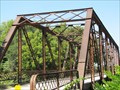 view gallery view galleryNW13.5 km | Cottonwood River Pratt Truss Bridge - Cedar Point, Kansas in U.S. National Register of Historic Places Truss bridge located west of Cedar Point, Kansas. posted by: BruceS location: Kansas date approved: 05/04/2011 last visited: 05/12/2011 |
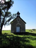 view gallery view galleryNW13.8 km | Bichet School, District 34 - Florence, Kansas in U.S. National Register of Historic Places Historic one-room schoolhouse in rural Marion county in vicinity of Florence, Kansas. posted by: BruceS location: Kansas date approved: 05/01/2011 last visited: 05/12/2011 |
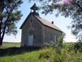
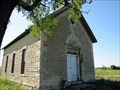 view gallery view galleryNW13.8 km |  Bichet School, District 34 - Florence, Kansas Bichet School, District 34 - Florence, Kansas
in Former Schools Historic one-room schoolhouse in rural Marion county in vicinity of Florence, Kansas. posted by: BruceS location: Kansas date approved: 05/01/2011 last visited: 05/12/2011 |
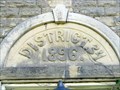 view gallery view galleryNW13.8 km |  1896 - Bichet School, District 34 - Florence, Kansas 1896 - Bichet School, District 34 - Florence, Kansas
in Dated Buildings and Cornerstones Historic one-room schoolhouse in rural Marion county in vicinity of Florence, Kansas. posted by: BruceS location: Kansas date approved: 05/01/2011 last visited: 05/12/2011 |
 view gallery view galleryNW13.8 km |  Bichet School, District 34 - Florence, Kansas Bichet School, District 34 - Florence, Kansas
in One-Room Schoolhouses Historic one-room schoolhouse in rural Marion county in vicinity of Florence, Kansas. posted by: BruceS location: Kansas date approved: 05/02/2011 last visited: 05/12/2011 |
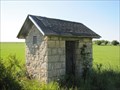 view gallery view galleryNW13.8 km |  Bichet School Outhouse - Florence, Kansas Bichet School Outhouse - Florence, Kansas
in Outhouses One of two matching outhouses for a former one-room school in rural Marion County, Kansas. posted by: BruceS location: Kansas date approved: 05/01/2011 last visited: 05/12/2011 |
 view gallery view gallery SE15.6 km SE15.6 km
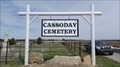
|  Cassoday Cemetery - Cassoday, KS Cassoday Cemetery - Cassoday, KS
in Worldwide Cemeteries Cassoday Cemetery is about a mile west of Cassoday, Kansas. posted by: The Snowdog location: Kansas date approved: 04/24/2023 last visited: never |
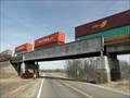 view gallery view gallery E16.3 km E16.3 km
|  A.T.&S.F. Ry. Bridge - Matfield Green KS A.T.&S.F. Ry. Bridge - Matfield Green KS
in Railroad Bridges This Railroad Bridge is A.T & S.F.RY. Bridge No. 147 C that crosses Kansas Highway 177, 3.25 miles south of Matfield Green, Kansas. posted by: PeterNoG location: Kansas date approved: 06/18/2014 last visited: 03/03/2011 |
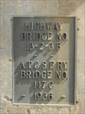 view gallery view galleryE16.3 km |  Highway/A.T.&S.F. Ry. Bridge - 1936 ~ Matfield Green KS Highway/A.T.&S.F. Ry. Bridge - 1936 ~ Matfield Green KS
in Bridge Date Stones and Plaques This Bridge Date Plaque is on A.T & S.F.RY. Bridge No. 147 C that crosses Kansas Highway 177, 3.25 miles south of Matfield Green, Kansas. posted by: PeterNoG location: Kansas date approved: 06/18/2014 last visited: 03/03/2011 |
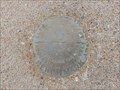 view gallery view galleryNW16.7 km | JF0257 - K 50 - 1934 Benchmark at the Florence, KS Train Depot in U.S. Benchmarks A benchmark disc is found on top of a concrete monument next to wood stanchions on the east end of the old train depot in Florence, KS. posted by: WayBetterFinder location: Kansas date approved: 11/28/2020 last visited: 11/29/2020 |
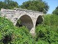 view gallery view galleryN16.7 km | Clements Stone Arch Bridge - Clements, Kansas in U.S. National Register of Historic Places Historic bridge now retired located near Clements, Kansas. posted by: BruceS location: Kansas date approved: 05/05/2011 last visited: 05/12/2011 |
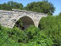 view gallery view galleryN16.7 km |  Clements Stone Arch Bridge - Clements, Kansas Clements Stone Arch Bridge - Clements, Kansas
in Stone Bridges Historic bridge now retired located near Clements, Kansas. posted by: BruceS location: Kansas date approved: 05/05/2011 last visited: 05/12/2011 |
 view gallery view galleryN16.7 km |  Clements Stone Arch Bridge - Clements, Kansas Clements Stone Arch Bridge - Clements, Kansas
in Arch Bridges Historic bridge now retired located near Clements, Kansas. posted by: BruceS location: Kansas date approved: 05/05/2011 last visited: 05/12/2011 |
 view gallery view galleryN16.7 km |  Clements Stone Arch Bridge - Clements, Kansas Clements Stone Arch Bridge - Clements, Kansas
in Orphaned Bridges Historic bridge now retired located near Clements, Kansas. posted by: BruceS location: Kansas date approved: 05/07/2011 last visited: 05/12/2011 |
|