 view gallery view gallery N0.3 km N0.3 km
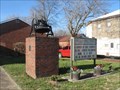
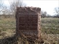
|   Bell of Congregational Church, Iberia, MO Bell of Congregational Church, Iberia, MO
in Bells A cast steel bell, presumably from a former building, stands on a brick and concrete pedestal outside the present building of the Congregational Church. posted by:  STLbells STLbells location: Missouri date approved: 01/03/2022 last visited: never |
 view gallery view gallery NE5.1 km NE5.1 km
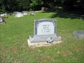
|  103 - Fred R. Moss - Iberia, Missouri 103 - Fred R. Moss - Iberia, Missouri
in Headstones of Centenarians I noticed this headstone and military marker at the Union Cemetery off Hwy 42 in Miller County, Missouri, about 5 miles from Iberia, Missouri. posted by:  Queens Blessing Queens Blessing location: Missouri date approved: 06/09/2011 last visited: 09/15/2012 |
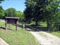 view gallery view galleryNE5.1 km |  Union Cemetery, Iberia Missouri Union Cemetery, Iberia Missouri
in Worldwide Cemeteries Union Cemetery is located next to Brays Advent Christian Church but is not associated with that church. posted by: Queens Blessing location: Missouri date approved: 06/01/2011 last visited: 09/15/2012 |
 view gallery view gallery NW6.4 km NW6.4 km
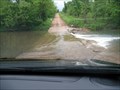
|  Ponder Slab, Iberia, Missouri Ponder Slab, Iberia, Missouri
in Bridgeless Water Crossings This bridgeless water crossing is located near Iberia, Missouri. posted by: Queens Blessing location: Missouri date approved: 06/26/2011 last visited: 09/15/2012 |
 view gallery view gallery S15.6 km S15.6 km
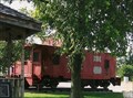
|  Frisco # 1418 re-numbered # 11648 - Frisco Park, Crocker, MO Frisco # 1418 re-numbered # 11648 - Frisco Park, Crocker, MO
in Train Cabooses "Crocker MO SLSF 1418 as BN 11648, steel, wide vision, built from boxcar 9/75, 10th & Main" ~ BN list posted by: YoSam. location: Missouri date approved: 05/05/2014 last visited: never |
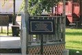 view gallery view galleryS15.6 km |  Norma Lea Mihalevich - Crocker, MO Norma Lea Mihalevich - Crocker, MO
in Missouri Historical Markers This park, The Frisco Park, is also dedicated to this woman who gave her life in service to this town. posted by: YoSam. location: Missouri date approved: 02/14/2016 last visited: never |
 view gallery view galleryS15.6 km |  Norma Lea's Frisco Park - Crocker, MO Norma Lea's Frisco Park - Crocker, MO
in Municipal Parks and Plazas This park is dedicated to both the railroad history of the town and a long time mayor. Web search shows a veterans memorial in the park, it was not there when I visited. posted by: YoSam. location: Missouri date approved: 02/14/2016 last visited: never |
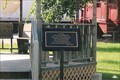 view gallery view galleryS15.6 km |  Norma Lea Mihalevich (teacher) - Crocker, MO Norma Lea Mihalevich (teacher) - Crocker, MO
in Citizen Memorials The Frisco Park is also dedicated to this woman who gave her life in service to this town. posted by: YoSam. location: Missouri date approved: 12/02/2019 last visited: never |
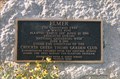 view gallery view galleryS15.8 km | Elmer The Christmas Tree - Crocker, MO in Missouri Historical Markers And yes, the school children decorate it each year. posted by: YoSam. location: Missouri date approved: 02/14/2016 last visited: never |
 view gallery view gallery SE20 km SE20 km
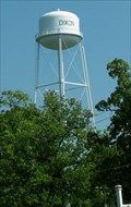
|  Water Tower in Dixon, Missouri Water Tower in Dixon, Missouri
in Water Towers This water tower is a prominent feature in the city park! posted by: Queens Blessing location: Missouri date approved: 05/31/2010 last visited: 09/02/2013 |
 view gallery view gallery W20.4 km W20.4 km
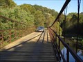
|  Grand Auglaize Swinging Bridge Grand Auglaize Swinging Bridge
in Suspension Bridges This is the longest of five swinging bridges located near lake of the Ozarks at Camdenton, MO. posted by: RGS location: Missouri date approved: 12/22/2006 last visited: 03/16/2022 |
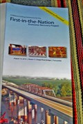 view gallery view galleryNW21.1 km |  FIRST-- Economic Recovery Project in the U.S. FIRST-- Economic Recovery Project in the U.S.
in Superlatives The Osage River Bridge on Route 17 near Tuscumbia, Missouri was the nation's first project to start construction under the American Recovery and Reinvestment Act signed by the President in 2009. The new bridge was opened to traffic on August 16, 2010 posted by: Carpe Diem59 location: Missouri date approved: 08/21/2010 last visited: never |
 view gallery view galleryW25.9 km | Boone's Lick Road - Head's Fort - 1812 in Missouri Historical Markers A granite monument placed by the Daughters of the American Revolution marking an important stop along the Boone's Lick Road. posted by: Utapao72 location: Missouri date approved: 12/10/2015 last visited: never |
 view gallery view galleryW25.9 km |  Ozark Caverns - Lake of the Ozarks Missouri State Park Ozark Caverns - Lake of the Ozarks Missouri State Park
in State Park Passport Locations The Ozark Caverns Visitors Center provides a stamping station for Missouri State Park Passports posted by: cldisme location: Missouri date approved: 06/26/2011 last visited: never |
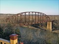 view gallery view galleryN27.4 km |  Osage River Bridge Rock Island Line near St. Elizabeth, MO Osage River Bridge Rock Island Line near St. Elizabeth, MO
in Orphaned Bridges The old Rock Island Line truss railroad bridge still crosses the Osage River near St. Elizabeth on the south bank to Henley on the north bank. posted by: Carpe Diem59 location: Missouri date approved: 12/10/2009 last visited: never |
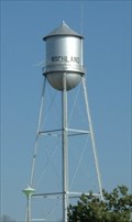 view gallery view galleryS27.4 km | RICHLAND - Water Tank in Water Towers RICHLAND, Missouri Municipal Water Tank posted by: GEO*Trailblazer 1 location: Missouri date approved: 01/30/2007 last visited: 01/30/2007 |
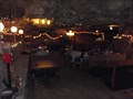 view gallery view galleryS27.8 km | Only Restaurant in a cave in the U.S. Richland, MO in Superlatives The Cave Restaurant
26880 Rochester Rd.
Richland, MO 65556
(573) 765-4554 posted by: kJfishman location: Missouri date approved: 04/22/2012 last visited: 10/10/2009 |
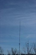 view gallery view galleryW28.3 km |  KRMS-FM 93.3, K254BE (KRMS-FM) 98.7, K227DJ (KRMS-AM) 103.3, K285ER (KRMS-FM) 104.9 - Osage Lake MO USA KRMS-FM 93.3, K254BE (KRMS-FM) 98.7, K227DJ (KRMS-AM) 103.3, K285ER (KRMS-FM) 104.9 - Osage Lake MO USA
in Radio and Television Transmitter Towers This FM radio broadcast tower posts hosts three low-power FM repeaters and one FM broadcast antenna for KRMS-AM and KRMS-FM 93.5 along the US 54 at Osage Beach, Missouri posted by: Benchmark Blasterz location: Missouri date approved: 03/23/2023 last visited: 03/25/2023 |
 view gallery view gallery E28.5 km E28.5 km
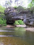
|  Clifty Creek Natural Area Maries County, Missouri Clifty Creek Natural Area Maries County, Missouri
in Natural Arches One of the dramatic features of Clifty Creek Natural Area is a natural bridge with a span of about 40 feet created by stream erosion of Gasconade dolomite rock formations. A trail loop of 2.5 miles completed in 2008 affords excellent access. posted by: Carpe Diem59 location: Missouri date approved: 04/30/2010 last visited: 02/21/2011 |
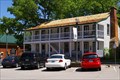
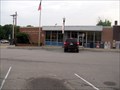 view gallery view galleryS29.9 km |  Waynesville, MO - 65583 Waynesville, MO - 65583
in U.S. Post Offices A classic brick and glass post office, very common in Missouri. posted by: Queens Blessing location: Missouri date approved: 06/30/2011 last visited: 09/10/2012 |
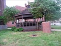 view gallery view galleryS29.9 km |  Courthouse Gazebo, Waynesville, MO Courthouse Gazebo, Waynesville, MO
in Gazebos This spacious wooden gazebo has a view facing the Post Office. posted by: Queens Blessing location: Missouri date approved: 06/30/2011 last visited: 09/15/2012 |
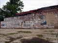 view gallery view galleryS29.9 km |  Faded ROUTE 66 mural, Waynesville, MO Faded ROUTE 66 mural, Waynesville, MO
in Murals This mural has seen better days; it is just a ghost of it's former self, very much like the Route 66 highway that is the topic of the mural. posted by: Queens Blessing location: Missouri date approved: 07/01/2011 last visited: 10/25/2020 |
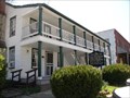 view gallery view galleryS29.9 km |  Old Stagecoach Stop - Waynesville, MO Old Stagecoach Stop - Waynesville, MO
in U.S. National Register of Historic Places Historic building in Waynesville, Missouri posted by: MoOzarksRegionalExplorers location: Missouri date approved: 04/19/2007 last visited: 12/08/2022 |
 view gallery view galleryS29.9 km | Old Stagecoach Stop - Waynesville, MO in Missouri Historical Markers Located off of historic Route 66, on North Lynn Street in Waynesville. posted by: S5280ft location: Missouri date approved: 05/15/2008 last visited: 12/08/2022 |
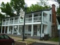
 view gallery view galleryS29.9 km |  Old Stage Coach Stop House Museum- Waynesville MO Old Stage Coach Stop House Museum- Waynesville MO
in History Museums Old Stage Coach Stop House Museum- Waynesville MO posted by: kJfishman location: Missouri date approved: 04/22/2012 last visited: 12/08/2022 |
|