 view gallery view gallery NE6.4 km NE6.4 km
|   Subway - Farmville, VA, near bypass Subway - Farmville, VA, near bypass
in Subway Restaurants One of two Farmville Subways, this one is in a shopping center near the US 460 bypass. posted by:  SwampThing777 SwampThing777 location: Virginia date approved: 08/21/2008 last visited: never |
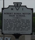 view gallery view galleryNE7.7 km |  Robert Russa Moton High School Robert Russa Moton High School
in Virginia Historical Markers Civil disobedience assisted legal decision on school desegregation. posted by:  vhasler vhasler location: Virginia date approved: 05/15/2011 last visited: never |
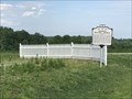
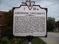 view gallery view galleryNE8.5 km | Longwood University in Virginia Historical Markers Located on Hwy. 15 (South Main St.) in Farmville posted by: 3newsomes location: Virginia date approved: 09/08/2010 last visited: 04/12/2013 |
 view gallery view galleryNE8.7 km |  McDonalds - Farmville, VA McDonalds - Farmville, VA
in McDonald's Restaurants Downtown Farmville - right next to Longwood University posted by: vhasler location: Virginia date approved: 07/06/2011 last visited: never |
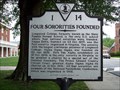 view gallery view galleryNE8.7 km | Four Sororities Founded in Virginia Historical Markers Located at High St. and Randolph St. in Farmville posted by: 3newsomes location: Virginia date approved: 09/08/2010 last visited: 04/12/2013 |
 view gallery view galleryNE9 km |  Art*o*mat at Longwood Center for the Visual Arts - Farmville, VA Art*o*mat at Longwood Center for the Visual Arts - Farmville, VA
in Art*o*mats Converted cigarette vending machine now provides original art for $5 token posted by: vhasler location: Virginia date approved: 05/03/2011 last visited: never |
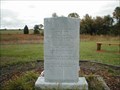
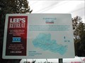 view gallery view galleryNE9.3 km |  Farmville-Lee’s Retreat - Farmville VA Farmville-Lee’s Retreat - Farmville VA
in U.S. Civil War Sites April 7, 1865-The Confederate army marched through this tobacco town, followed by the Union army. Lee hoped to issue rations to his men here before turning south but was forced to flee across the Appomattox River. posted by: Don.Morfe location: Virginia date approved: 10/05/2020 last visited: 10/01/2021 |
 view gallery view gallery E11.7 km E11.7 km
| Sharon Baptist Church in Virginia Historical Markers Virginia Historical Highway Marker M-34 posted by: garmin_geek location: Virginia date approved: 06/01/2017 last visited: never |
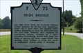 view gallery view galleryE12.7 km | High Bridge in Virginia Historical Markers High Bridge spans the Appomattox River, about 6-miles east of Farmville, Virginia. This historic marker is located on U. S. Route 460 just a couple of miles from the bridge. posted by: Sneakin Deacon location: Virginia date approved: 01/07/2008 last visited: 02/21/2009 |
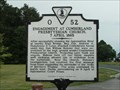 view gallery view galleryNE13.4 km | Engagement At Cumberland Presybterian Church, 7 April 1865 in Virginia Historical Markers Located at Cumberland Rd. and CR 1008 north of Farmville posted by: 3newsomes location: Virginia date approved: 09/08/2010 last visited: 05/28/2010 |
 view gallery view galleryNE14.2 km |  High Bridge Trail, River Road Access High Bridge Trail, River Road Access
in Rails to Trails River Road parking for the High Bridge Trail State Park. posted by: garmin_geek location: Virginia date approved: 05/21/2012 last visited: never |
 view gallery view galleryNE14.2 km |  River Road Parking, High Bridge Trail, nr. Farmville, VA River Road Parking, High Bridge Trail, nr. Farmville, VA
in Hiking and walking trailheads River Road access point for the 31 mile long high Bridge Trail State Park. The High Bridge is about 1 mile away. posted by: garmin_geek location: Virginia date approved: 06/30/2012 last visited: 08/30/2019 |
 view gallery view galleryNE14.6 km |  High Bridge Trail near Farmville, VA High Bridge Trail near Farmville, VA
in Hiking Path Footbridges The High Bridge is the center piece of the 31 mile long rail-to-trail. posted by: garmin_geek location: Virginia date approved: 05/11/2012 last visited: 08/30/2019 |
 view gallery view galleryNE14.6 km |  High Bridge Trail, Appomattox River Bridge - Prince Edward County, Virginia, High Bridge Trail, Appomattox River Bridge - Prince Edward County, Virginia,
in Railroad Bridges A Norfolk Southern rail line that has been turned into a VA state park trail. 2,400 feet long and 125 feet above the Appomattox River. The original bridge was built in 1853 as part of the South Side Railroad. posted by: garmin_geek location: Virginia date approved: 05/10/2012 last visited: 05/31/2017 |
 view gallery view gallery S17.4 km S17.4 km
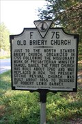
| Old Briery Church in Virginia Historical Markers This marker commemorates a nearby Presbyterian church built in about 1855. A church has stood on this site since before the Revolutionary War. posted by: SwampThing777 location: Virginia date approved: 09/05/2007 last visited: never |
 view gallery view gallery W18.2 km W18.2 km
| High Bridge Trail State Park in Rails to Trails The 31 mile long High Bridge Trail traverses Cumberland, Nottoway and Prince Edward counties and the towns of Burkeville, Farmville, Pamplin City, Prospect and Rice. posted by: garmin_geek location: Virginia date approved: 06/06/2017 last visited: never |
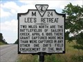 view gallery view galleryE20.1 km | Lee's Retreat in Virginia Historical Markers This historic marker is located on Virginia Route 307 near the Sailor's Creek Battlefield posted by: Sneakin Deacon location: Virginia date approved: 06/22/2008 last visited: 06/17/2011 |
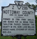 view gallery view galleryE20.1 km | Prince Edward County/Nottoway County in Virginia Historical Markers County line - one side named for a prince, the other an Indian tribe posted by: vhasler location: Virginia date approved: 05/15/2011 last visited: never |
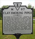 view gallery view galleryW20.4 km | Clay Smoking Pipes in Virginia Historical Markers Local area was major manufacturing center for clay pipes used for smoking posted by: vhasler location: Virginia date approved: 05/15/2011 last visited: never |
 view gallery view galleryE21.2 km | Marshall’s Crossroads-Lee’s Retreat - Rice VA in U.S. Civil War Sites April 6, 1865-Union cavalry found Confederate infantry posted here along the road to Rice’s Depot. While others fought along Little Sailor’s Creek at Hillsman’s farm. posted by: Don.Morfe location: Virginia date approved: 10/05/2020 last visited: 10/01/2021 |
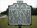
 view gallery view galleryE21.6 km | Battle of Sailors Creek - Rice VA in U.S. Civil War Sites (Front): Battles of Sailors Creek April 6, 1865 (Back): In remembrance of the Confederate and Union Soldiers who fought in the surrounding hills with great honor and perseverance on April 6, 1865. posted by: Don.Morfe location: Virginia date approved: 10/05/2020 last visited: 10/01/2021 |
 view gallery view galleryE21.6 km | Sailor'Creek Battlefield Historic State Park - Amelia County, Virginia in Civil War Discovery Trail Sites The Battle of Sailor's Creek took place on April 6, 1865 and was one of the final battles of the Civil War in Virginia. posted by: Sneakin Deacon location: Virginia date approved: 08/27/2007 last visited: never |
 view gallery view galleryE21.6 km |  Sayler's Creek Battlefield - Amelia County, Virginia Sayler's Creek Battlefield - Amelia County, Virginia
in U.S. National Register of Historic Places The Battle of Sailor's Creek took place on April 6, 1865 and was one of the final battles of the Civil War in Virginia.
posted by: Sneakin Deacon location: Virginia date approved: 01/04/2008 last visited: never |
 view gallery view galleryE21.6 km |  Sailor's Creek Battlefield - Amelia County, Virginia Sailor's Creek Battlefield - Amelia County, Virginia
in Battlefields The Battle of Sailor's Creek took place on April 6, 1865 and was one of the final battles of the Civil War in Virginia. posted by: Sneakin Deacon location: Virginia date approved: 01/05/2008 last visited: never |
 view gallery view galleryE22.4 km |  Hillsman House - Jetersville VA Hillsman House - Jetersville VA
in Field Hospitals The Hillsman House was used by the Unionists as a hospital in the engagement of April 6, 1865, Battle of Sailor's (Sayler's) Creek. posted by: Don.Morfe location: Virginia date approved: 08/26/2023 last visited: 08/26/2023 |
|