 view gallery view gallery SE14.2 km SE14.2 km
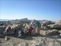
|   Mt. Whitney Mt. Whitney
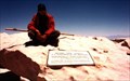
in Mountain Summits Mt Whitney is the highest point in the contiguous United States. posted by:  wilsonjw wilsonjw location: California date approved: 09/08/2005 last visited: 08/01/2013 |
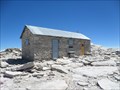 view gallery view gallerySE14.2 km |  Smithsonian Institution Shelter - Mt. Whitney, CA Smithsonian Institution Shelter - Mt. Whitney, CA
in U.S. National Register of Historic Places Mt. Whitney Smithsonian Research Facility
Sequoia National Park, CA posted by: fresgo location: California date approved: 08/06/2013 last visited: 08/05/2013 |
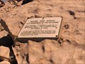
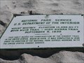 view gallery view gallerySE14.2 km |  Highest Point in California (Mt Whitney) Highest Point in California (Mt Whitney)
in Geographic High Points Mt Whitney at 14,505 feet is the highest point in California, as well as the lower 48 states and both Tulare and Inyo counties. posted by: Rumpled location: California date approved: 10/20/2008 last visited: 08/04/2013 |
 view gallery view gallerySE14.2 km | Highest Point in Tulare County (Mt Whitney) in Geographic High Points Mt Whitney at 14,505 feet is the highest point in Tulare County, as well as the lower 48 states, the state of California and Inyo County. posted by: Rumpled location: California date approved: 10/20/2008 last visited: 08/04/2013 |
 view gallery view gallerySE14.2 km | Highest Point in Inyo County (Mt Whitney) in Geographic High Points Mt Whitney at 14,505 feet is the highest point in Inyo County, as well as the lower 48 states, the state of California and Tulare County.
posted by: Rumpled location: California date approved: 10/20/2008 last visited: 08/01/2013 |
 view gallery view gallery E19.6 km E19.6 km
|  Mt Williamson Sierra Nevada Mt Williamson Sierra Nevada
in Ansel Adams Photo Hunt Ansel Adams Mt Williamson Sierra Nevada photograph location posted by:  bdouglas bdouglas location: California date approved: 04/18/2006 last visited: 10/24/2010 |
 view gallery view gallerySE20.4 km |  Whitney Portal National Recreation Trail Whitney Portal National Recreation Trail
in Hiking and walking trailheads Lone Pine Campground, Inyo National Forest. The trail head is at the west end of the campground. Parking is available in the Day Use Area. posted by: fresgo location: California date approved: 08/11/2013 last visited: never |
 view gallery view galleryE21.4 km | Manzanar Cemetery in Ansel Adams Photo Hunt Ansel Adams visited the Manzanar War Relocation Camp in 1943 and took over 200 images of the camp during his visit. The original glass plates are housed in the Library of Congress. posted by: Touchstone location: California date approved: 09/01/2009 last visited: 03/04/2022 |
 view gallery view galleryE21.4 km |  Manzanar Pet Cemetery Manzanar Pet Cemetery
in Pet Cemeteries The Manzanar Pet Cemetery is located just outside the barbed wire enclosure of the internment camp, adjacent to the famous Obelisk that marks the Manzanar Cemetery. posted by: Touchstone location: California date approved: 09/03/2009 last visited: 05/13/2021 |
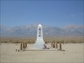 view gallery view galleryE21.4 km |  Manzanar Cemetery - Independence, California Manzanar Cemetery - Independence, California
in Obelisks This 15 foot obelisk stands in the center of the Manzanar Cemetery on the Western edge of the Internment Camp. posted by: Touchstone location: California date approved: 09/01/2009 last visited: 03/04/2022 |
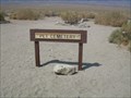
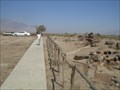
 view gallery view galleryE21.4 km |  Camp Cemetery-Manzanar National Historic SIte - Independence CA Camp Cemetery-Manzanar National Historic SIte - Independence CA
in Worldwide Cemeteries The Camp Cemetery is in Manzanar National Historic Site. The site was where Japanese Americans were held during World War II from April 1942 to November 1945. posted by: Don.Morfe location: California date approved: 03/11/2022 last visited: 03/04/2022 |
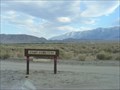
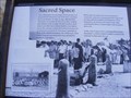 view gallery view galleryE21.4 km |  Sacred Space-Manzanar National Historic Site - Independence CA Sacred Space-Manzanar National Historic Site - Independence CA
in Signs of History Life at Manzanar was uncertain, but the prospect of dying behind barbed wire, far from home, may have been unthinkable. On May 16, 1943, Matsunosuke Murakami, 62, became the first of 150 men, women, and children to die in camp. posted by: Don.Morfe location: California date approved: 09/22/2020 last visited: 09/26/2021 |
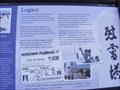 view gallery view galleryE21.4 km | Legacy-Manzanar National Historic Site - Independence CA in Signs of History Over the years, this monument has become an icon, inspiring a grass-roots movement to preserve Manzanar and remember the sacrifices of 120,313 Japanese Americans confined by their own government. posted by: Don.Morfe location: California date approved: 09/22/2020 last visited: 09/26/2021 |
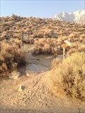
 view gallery view galleryE21.6 km |  San-shi-en Garden - Manzanar, California San-shi-en Garden - Manzanar, California
in Japanese Gardens The San-shi-en or 3-4 Garden, is located within the Manzanar Relocation Camp along I395. Once home to over 10,000 Americans of Japanese descent, the Camp is now entrusted to the care of the National Park Service. posted by: Touchstone location: California date approved: 09/08/2009 last visited: 03/04/2022 |
 view gallery view gallery NE21.7 km NE21.7 km
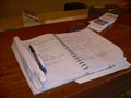
|  Mount Whitney Fish Hatchery Guestbook - Independence, California Mount Whitney Fish Hatchery Guestbook - Independence, California
in Guest Books The guestbook for the historic Mount Whitney Fish Hatchery is located on the check out counter for the Gift Shop. posted by: Touchstone location: California date approved: 09/03/2009 last visited: 08/04/2012 |
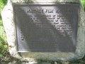 view gallery view galleryNE21.7 km |  Mount Whitney Fish Hatchery - Independence, California Mount Whitney Fish Hatchery - Independence, California
in E Clampus Vitus Historical Markers Located at the historic Mount Whitney Fish Hatchery, this plaque explains some of the history of how the hatchery came to be built. posted by: Touchstone location: California date approved: 09/02/2009 last visited: 02/12/2014 |
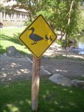 view gallery view galleryNE21.7 km |  Duck Crossing - Mount Whitney Fish Hatchery, Independence, California Duck Crossing - Mount Whitney Fish Hatchery, Independence, California
in Uncommon Crossing Signs A duck crossing sign to warn drivers accessing the historic fish hatchery. posted by: Touchstone location: California date approved: 09/02/2009 last visited: 08/04/2012 |
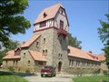 view gallery view galleryNE21.7 km |  Mount Whitney Fish Hatchery - Independence, California Mount Whitney Fish Hatchery - Independence, California
in Fish Hatcheries One of the oldest operating fish hatcheries in California, the historic building and brood ponds offer a relaxing place to picnic on any trip through the Owens Valley. posted by: Touchstone location: California date approved: 09/02/2009 last visited: 05/15/2014 |
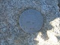 view gallery view gallerySE21.9 km |  Mount Langley - California Mount Langley - California
in U.S. Benchmarks A benchmark located on the summit of Mount Langley in the Sierra mountain range of California. posted by: Touchstone location: California date approved: 09/01/2009 last visited: 09/07/2016 |
 view gallery view gallerySE21.9 km | Mount Langley in Mountain Summits The lowest of the 14'ers in California, as well as technically the easiest to reach and ascend. posted by: Touchstone location: California date approved: 08/31/2009 last visited: never |
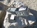 view gallery view gallerySE21.9 km |  Mount Langley - California Mount Langley - California
in Summit Registers Located on the summit of Mount Langley (14,022 feet) in the Southern Sierra of California. posted by: Touchstone location: California date approved: 08/30/2009 last visited: never |
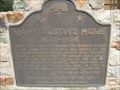 view gallery view galleryNE22 km |  Mary Austin's Home - CHL No. 229 Mary Austin's Home - CHL No. 229
in California Historical Markers The historical marker is located in front of a private home at 253 Market Street in Independence CA. posted by: The Fat Cats location: California date approved: 07/05/2015 last visited: 06/05/2017 |
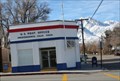 view gallery view galleryNE22.2 km |  INDEPENDENCE, CA 93526 INDEPENDENCE, CA 93526
in U.S. Post Offices This is one of the SMALL Post Offices posted by: Tissa1020 & Foxhound location: California date approved: 01/16/2009 last visited: 10/24/2018 |
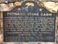 view gallery view galleryNE22.2 km | Putnam’s Stone Cabin in California Historical Markers Located along the Three Flags Highway (US 395) in Independence, CA. posted by: fresgo location: California date approved: 05/31/2011 last visited: never |
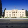 view gallery view galleryNE22.4 km | Inyo County Courthouse - Independence, CA in U.S. National Register of Historic Places The Inyo County Courthouse in Independence. posted by: saopaulo1 location: California date approved: 05/07/2016 last visited: 05/13/2021 |
|