 view gallery view gallery NE1.3 km NE1.3 km
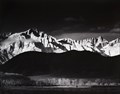
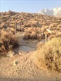
|   Ansel Adams - Winter Sunrise of Mt Whitney from Lone Pine, CA Ansel Adams - Winter Sunrise of Mt Whitney from Lone Pine, CA
in Ansel Adams Photo Hunt Ansel Adams - Winter Sunrise of Mt Whitney from Lone Pine, CA posted by:  05auditt 05auditt location: California date approved: 06/11/2013 last visited: 07/21/2014 |
 view gallery view gallery N2.3 km N2.3 km
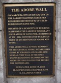
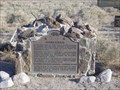
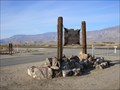
|  The Adobe Wall The Adobe Wall
in E Clampus Vitus Historical Markers This E Clampus Vitus Historical Marker is located in Lone Pine, CA. posted by: Team Min Dawg location: California date approved: 07/24/2009 last visited: 03/28/2014 |
 view gallery view galleryN2.4 km |  Lone Pine, California 93545 Lone Pine, California 93545
in U.S. Post Offices This Post Office is located at 121 E Bush Street in Lone Pine, California. posted by:  brwhiz brwhiz location: California date approved: 02/03/2013 last visited: 10/24/2018 |
 view gallery view galleryNE2.7 km |  Southern Inyo Hospital - Lone Pine, CA Southern Inyo Hospital - Lone Pine, CA
in Hospitals This little hospital is located in Lone Pine. I'm guessing the hospital sees lots of cases related to hiking and fishing! posted by: Free2bme29 location: California date approved: 07/06/2009 last visited: 02/08/2014 |
 view gallery view galleryN3.5 km |  1872 Earthquake Victims Cemetery- Lone Pine, California, USA 1872 Earthquake Victims Cemetery- Lone Pine, California, USA
in Abandoned Cemeteries North of Lone Pine on Rt 395 is the mass grave site for the victims of the March 26, 1872 earthquake that destroyed the town. The earthquake struck at 2:10am. 27 people in Lone Pine were killed during the quake. posted by: calgriz location: California date approved: 09/09/2014 last visited: 05/13/2021 |
 view gallery view gallery NW5.8 km NW5.8 km
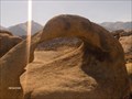
|  Whitney Arch, Alabama Hills Whitney Arch, Alabama Hills
in Natural Arches This is the famous arch on the postcards that you can see Mt Whitney through. Also called mobius arch, due to it's twisting shape. posted by: Rumpled location: California date approved: 10/20/2008 last visited: 08/16/2012 |
 view gallery view gallery W10.5 km W10.5 km
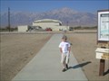
|  Whitney Portal National Recreation Trail Whitney Portal National Recreation Trail
in Hiking and walking trailheads Lone Pine Campground, Inyo National Forest. The trail head is at the west end of the campground. Parking is available in the Day Use Area. posted by: fresgo location: California date approved: 08/11/2013 last visited: never |
 view gallery view gallery SW16.6 km SW16.6 km
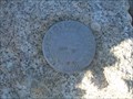
|  Mount Langley - California Mount Langley - California
in U.S. Benchmarks A benchmark located on the summit of Mount Langley in the Sierra mountain range of California. posted by: Touchstone location: California date approved: 09/01/2009 last visited: 09/07/2016 |
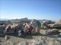 view gallery view gallerySW16.6 km |  Mount Langley Mount Langley
in Mountain Summits The lowest of the 14'ers in California, as well as technically the easiest to reach and ascend. posted by: Touchstone location: California date approved: 08/31/2009 last visited: never |
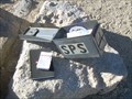 view gallery view gallerySW16.6 km |  Mount Langley - California Mount Langley - California
in Summit Registers Located on the summit of Mount Langley (14,022 feet) in the Southern Sierra of California. posted by: Touchstone location: California date approved: 08/30/2009 last visited: never |
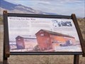 view gallery view galleryNW16.7 km |  Weaving for the War (Manzanar National Historic Site)-Independence, CA Weaving for the War (Manzanar National Historic Site)-Independence, CA
in Signs of History America went to work for the war effort in 1942, and Manzanar was no exception. More than 500 young Japanese Americans wove camouflage nets here for the U.S. Army. posted by: Don.Morfe location: California date approved: 11/28/2019 last visited: 09/28/2021 |
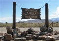
 view gallery view galleryNW16.9 km |  Manzanar War Relocation Center (#850): Lone Pine/Independance, CA Manzanar War Relocation Center (#850): Lone Pine/Independance, CA
in California Historical Markers It is at the entrance to the Manzanar War Relcoation Center, site of the internment of approximately 10,000 "persons of Japanese ancestry" in response to Executive Order 9066 and general fear/paranoia. The events of late make the Taskmasters fear we did not learn our lesson. posted by: Team Taskmaster location: California date approved: 06/15/2006 last visited: 03/04/2022 |
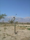 view gallery view galleryNW17.1 km |  Manzanar National Historic Site Weather Station - Independence, California Manzanar National Historic Site Weather Station - Independence, California
in Weather Stations The official weather station for the Manzanar National Historic Site, sits just to the South of the main Visitors Center. posted by: Touchstone location: California date approved: 09/01/2009 last visited: 03/04/2022 |
 view gallery view galleryNW17.2 km |  Manzanar War Relocation Center – Manzanar, CA Manzanar War Relocation Center – Manzanar, CA
in WWII Prisoner of War Camps The Manzanar War Relocation Center was one of ten camps where Japanese American citizens and resident Japanese aliens were interned during World War II. Over 10,000 people lived here at its height. posted by: Merlin-N-Mim location: California date approved: 05/29/2012 last visited: 03/04/2022 |
 view gallery view galleryNW17.2 km | Lone Pine/Independance, CA: Manzanar War Relocation Camp entrance in Ansel Adams Photo Hunt This entrance sign for the Manzanar War Relocation Camp is one of two we found, though inadvertently. posted by: Team Taskmaster location: California date approved: 06/15/2006 last visited: 03/04/2022 |
 view gallery view galleryNW17.2 km |  Manzanar - Independence CA Manzanar - Independence CA
in Wikipedia Entries Manzanar is the site of one of ten American concentration camps, where more than 120,000 Japanese Americans were incarcerated during World War II from March 1942 to November 1945. posted by: Don.Morfe location: California date approved: 03/04/2022 last visited: 03/04/2022 |
 view gallery view galleryNW17.2 km |  Manzanar National Historic Site - Independence, California Manzanar National Historic Site - Independence, California
in NPS Passport Cancellation Stations Located in the Visitors Center of the Historic Site, the coordinates should bring you to the front enterence. The stamp was located at the main desk in the Gift Shop at the time of our visit. posted by: Touchstone location: California date approved: 09/01/2009 last visited: 03/04/2022 |
 view gallery view galleryNW17.2 km |  Manzanar National Historic Site - Independence CA Manzanar National Historic Site - Independence CA
in Civil Rights Memorials Manzanar is the site of one of ten American concentration camps, where more than 120,000 Japanese Americans were incarcerated during World War II from March 1942 to November 1945. posted by: Don.Morfe location: California date approved: 10/02/2022 last visited: 10/02/2022 |
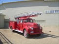 view gallery view galleryNW17.2 km |  Manzanar Fire Engine - Independence, California Manzanar Fire Engine - Independence, California
in Fire Fighting Vehicles Manzanar War Relocation Camp, now the Manzanar National Historic Site, had a Volunteer Fire Department and this was their Engine. posted by: Touchstone location: California date approved: 09/01/2009 last visited: 03/04/2022 |
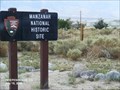
 view gallery view galleryNW17.2 km | ") Manzanar National Historic Site - Independence, California Manzanar National Historic Site - Independence, California
in National Parks (U.S.) Located 6 miles North of Independence, California, Manzanar War Relocation Camp is now operated by the National Park Service as a National Historic Site. posted by: Touchstone location: California date approved: 09/02/2009 last visited: 03/04/2022 |
 view gallery view galleryNW17.2 km |  Manzanar National Historic Site - Independence CA Manzanar National Historic Site - Independence CA
in National Parks of the World Manzanar is the site of one of ten American concentration camps, where more than 120,000 Japanese Americans were incarcerated during World War II from March 1942 to November 1945. posted by: Don.Morfe location: California date approved: 03/05/2022 last visited: 03/04/2022 |
 view gallery view galleryNW17.2 km |  Manzanar National Historic Site - Independence CA Manzanar National Historic Site - Independence CA
in Official Local Tourism Attractions Manzanar is the site of one of ten American concentration camps, where more than 120,000 Japanese Americans were incarcerated during World War II from March 1942 to November 1945. posted by: Don.Morfe location: California date approved: 03/05/2022 last visited: 03/04/2022 |
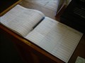 view gallery view galleryNW17.2 km |  Manzanar National Historic Site Guest Book - Independence, California Manzanar National Historic Site Guest Book - Independence, California
in Guest Books Located in the Visitors Center of the Manzanar National Historic Site, the rest of the Center is filled with first hand accounts as well as interpretative diplays that are well worth the visit. posted by: Touchstone location: California date approved: 09/02/2009 last visited: 10/03/2018 |
 view gallery view galleryNW17.2 km |  Manzanar National Historic Site - Independence CA Manzanar National Historic Site - Independence CA
in Satellite Imagery Oddities Manzanar is most widely known as the site of one of ten camps where over 110,000 Japanese Americans were imprisoned during World War II. posted by: Don.Morfe location: California date approved: 03/04/2022 last visited: 03/04/2022 |
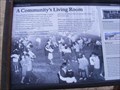 view gallery view galleryNW17.2 km | A Community's Living Room-Manzanar National Historic Site - Independence CA in Signs of History This auditorium is one of three original buildings remaining here from Manzanar War Relocation Center. As you walk closer, listen for laughter, tears, music—the sounds of celebration and sadness that once echoed through this building’s cavernous space. posted by: Don.Morfe location: California date approved: 09/21/2020 last visited: 09/26/2021 |
|