 view gallery view gallery NW9.3 km NW9.3 km
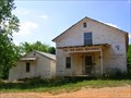
|   Trew General Merchandise Store Trew General Merchandise Store
in U.S. National Register of Historic Places Quaint local General Store on the back roads of Tennessee history added to the National Register of Historic Places in1976
(Building - #76002159) posted by:  Better Half Better Half location: Tennessee date approved: 07/19/2008 last visited: 07/19/2008 |
 view gallery view gallery NE10.8 km NE10.8 km
|  Conasauga Cemetery Conasauga Cemetery
in Worldwide Cemeteries East Etowah, TN
McMinn County
Tennessee USA posted by: Better Half location: Tennessee date approved: 08/18/2008 last visited: never |
 view gallery view gallery SW14.5 km SW14.5 km
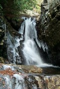
|  Rock Creek Falls Rock Creek Falls
in Waterfalls Ocoee/Benton, TN: Small waterfalls along the Scenic Spur Trail #78 posted by: The Yoyo Man location: Tennessee date approved: 12/11/2006 last visited: 02/19/2007 |
 view gallery view gallery S15.6 km S15.6 km
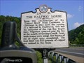
|  THE HALFWAY HOUSE 2A 51 THE HALFWAY HOUSE 2A 51
in Tennessee Historical Markers THE HALFWAY HOUSE posted by: Better Half location: Tennessee date approved: 09/09/2007 last visited: 06/23/2010 |
 view gallery view gallerySW17.1 km |  Chilhowee Mountain Overlook - 2280ft Chilhowee Mountain Overlook - 2280ft
in Elevation Signs Chilhowee Mountain Overlook is on the east side of Chilhowee Mountain. It looks out on Big Frog Mountain, Fort Mountain, Sugarloaf Mountain and other sights. posted by: fatcat161 location: Tennessee date approved: 10/07/2009 last visited: never |
 view gallery view gallery N17.4 km N17.4 km
|  McMinn County Airport – Athens, TN McMinn County Airport – Athens, TN
in Airports The state licensed McMinn County Airport is located about two miles southeast of downtown Athens. posted by:  timnjan timnjan location: Tennessee date approved: 01/29/2007 last visited: never |
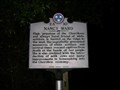 view gallery view gallerySW17.4 km | Nancy Ward - 2A 10 in Tennessee Historical Markers Located near Benton, TN. posted by: Better Half location: Tennessee date approved: 06/26/2008 last visited: 10/02/2008 |
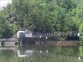 view gallery view galleryS18 km | Ocoee Hydroelectric Plant No. 2 - Polk County, TN in U.S. National Register of Historic Places The building of this dam started in 1911 and finished in 1913. It was put on the National Register of Historic Places in 1979. posted by: debbado location: Tennessee date approved: 07/08/2009 last visited: 03/27/2023 |
 view gallery view galleryS18 km |  Ocoee Dam No. 2 - Polk County, TN Ocoee Dam No. 2 - Polk County, TN
in Wikipedia Entries The building of this dam started in 1911 and finished in 1913. It was put on the National Register of Historic Places in 1979. posted by: debbado location: Tennessee date approved: 07/10/2009 last visited: 03/27/2023 |
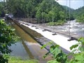 view gallery view galleryS18 km |  Ocoee Dam No. 2 - Polk County, TN Ocoee Dam No. 2 - Polk County, TN
in Water Dams The building of this dam started in 1911 and finished in 1913. It was put on the National Register of Historic Places in 1979. posted by: debbado location: Tennessee date approved: 07/08/2009 last visited: 03/27/2023 |
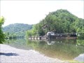
 view gallery view gallerySW20.1 km |  Parksville Lake Parksville Lake
in 'You Are Here' Maps Cherokee National Forest
Ocoee Scenic Byway posted by: Better Half location: Tennessee date approved: 09/15/2007 last visited: 07/13/2013 |
 S20.3 km |  Tanasi Trail System Tanasi Trail System
in Mountain Bike Trailheads 30 miles of trail begin at the white water center where the 1996 Olympic Canoe and Kayak Slalom competitions were held. posted by: AB4N location: Tennessee date approved: 08/19/2005 last visited: 06/25/2009 |
 view gallery view gallerySW20.3 km |  The Ocoee Gondolier - Ocoee, TN The Ocoee Gondolier - Ocoee, TN
in Independent Pizza Restaurants Located between the town of Ocoee and Lake Ocoee on Hwy 64. posted by: fatcat161 location: Tennessee date approved: 10/07/2009 last visited: 08/14/2011 |
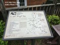
 view gallery view galleryS20.4 km | You Are Here - Old Copper Road Trail in 'You Are Here' Maps Located in the Ocoee Whitewater Center on US Hwy 64. posted by: debbado location: Tennessee date approved: 07/09/2009 last visited: 06/25/2009 |
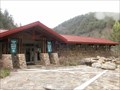 view gallery view galleryS20.4 km |  Ocoee Whitewater Center 1996 Olympics - Cherokee National Forest, TN Ocoee Whitewater Center 1996 Olympics - Cherokee National Forest, TN
in Modern Olympic Venues The Ocoee Whitewater Center was developed to host the Whitewater Canoeing and Kayaking events for the 1996 Olympics in Atlanta, GA. posted by: cldisme location: Tennessee date approved: 04/12/2009 last visited: 07/13/2013 |
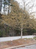 view gallery view galleryS20.4 km |  James Davidson - Cherokee National Forest, TN James Davidson - Cherokee National Forest, TN
in Dedicated Trees A simple dedication for James Davidson (1982-1996). posted by: cldisme location: Tennessee date approved: 06/11/2009 last visited: 07/13/2013 |
 view gallery view gallery E20.4 km E20.4 km
|  Coker Creek-Caught in the Middle - Tellico Plains TN Coker Creek-Caught in the Middle - Tellico Plains TN
in Civil War Discovery Trail Sites Here in the shadow of the Unicoi Mountains, the Coker Creek community suffered the effects of the Civil War. The conflict closed the lucrative gold mines here and brought devastation and terror to the inhabitants. posted by: Don.Morfe location: Tennessee date approved: 07/05/2020 last visited: 09/24/2021 |
 view gallery view galleryE20.4 km | Coker Creek-Caught in the Middle - Tellico Plains TN in U.S. Civil War Sites Here in the shadow of the Unicoi Mountains, the Coker Creek community suffered the effects of the Civil War. The conflict closed the lucrative gold mines here and brought devastation and terror to the inhabitants. posted by: Don.Morfe location: Tennessee date approved: 06/20/2023 last visited: 06/20/2023 |
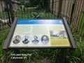
 view gallery view galleryE20.4 km |  Unicoi Turnpike Trail Path Through Time - Tellico Plains TN Unicoi Turnpike Trail Path Through Time - Tellico Plains TN
in Signs of History The path now known as the Unicoi Turnpike Trail has existed for over 1,000 year. The earliest European maps of the area note the trail as a connector between Cherokee Territories and the coastal ports of Charleston and Savannah. posted by: Don.Morfe location: Tennessee date approved: 10/28/2020 last visited: 09/24/2021 |
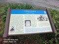
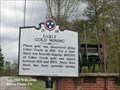 view gallery view galleryE20.4 km | Early Gold Mining (1F 18) - Tellico Plains TN in Tennessee Historical Markers Placer gold was discovered along Coker Creek in 1831. For a time there was feverish digging; $80,000 of Coker Creek gold was mined between 1831 and 1854. Since then there has been sporadic mining here. posted by: Don.Morfe location: Tennessee date approved: 10/18/2020 last visited: 10/20/2021 |
 view gallery view gallerySW20.4 km |  River Maze River Maze
in Outdoor Mazes River Maze posted by: Better Half location: Tennessee date approved: 09/15/2007 last visited: 08/14/2011 |
 view gallery view galleryS21.1 km |  Ocoee Blue Holes Ocoee Blue Holes
in Swimming Holes Blue Holes located near the Ocoee Whitewater Center posted by: AB4N location: Tennessee date approved: 08/26/2005 last visited: never |
 view gallery view gallery W22.2 km W22.2 km
| The Henegar House-"A bird can't live here!" - Charleston TN in Civil War Discovery Trail Sites During the war, Henegar House’s occupants, as in many other Tennessee homes, were divided in their loyalties. Henry Benton Henegar, the owner, was a Unionist while his wife, Margaret Lea Henegar, was a secessionist. posted by: Don.Morfe location: Tennessee date approved: 05/11/2020 last visited: 10/06/2021 |
 view gallery view galleryW22.2 km | Henegar House - Charleston TN in U.S. National Register of Historic Places The Henegar House is a historic house in Charleston, Tennessee. Constructed in 1849, it is the oldest remaining brick structure in Bradley County. It was listed on the National Register of Historic Places (NRHP) in 1976. posted by: Don.Morfe location: Tennessee date approved: 11/16/2022 last visited: 11/10/2022 |
 view gallery view galleryW22.2 km | Henegar House - Charleston TN in Wikipedia Entries The Henegar House is a historic house in Charleston, Tennessee. Constructed in 1849, it is the oldest remaining brick structure in Bradley County. It was listed on the National Register of Historic Places (NRHP) in 1976. posted by: Don.Morfe location: Tennessee date approved: 11/10/2022 last visited: 11/10/2022 |
|