 view gallery view gallery SE1.1 km SE1.1 km
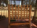
|   Connect 4-Pine Arizona Connect 4-Pine Arizona
in Giant Board Games Play Connect 4 on the patio at That Brewery.. posted by:  grandmabetsy grandmabetsy location: Arizona date approved: 04/16/2018 last visited: never |
 view gallery view gallery W6.1 km W6.1 km
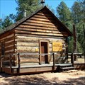
|  One Room Schoolhouse, Strawberry, AZ One Room Schoolhouse, Strawberry, AZ
in One-Room Schoolhouses This is a one room schoolhouse in Strawberry, AZ. posted by: Poehunters location: Arizona date approved: 08/16/2013 last visited: 10/11/2020 |
 view gallery view gallery S7.1 km S7.1 km
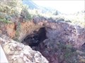
|  Tonto Natural Bridge State Park - Arizona Tonto Natural Bridge State Park - Arizona
in State/Provincial Parks Tonto Natural Bridge State Park is dedicated to the largest natural travertine arch in the world. posted by: adenium location: Arizona date approved: 07/22/2010 last visited: 10/19/2019 |
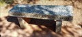 view gallery view galleryS7.2 km |  Ben Fields - Tonto Natural Bridge State Park, AZ Ben Fields - Tonto Natural Bridge State Park, AZ
in Dedicated Benches This bench commemorates Ben Fields. posted by: rjmcdonough1 location: Arizona date approved: 10/27/2019 last visited: never |
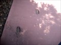 view gallery view galleryS7.2 km |  Animal Tracks - Tonto Natural Bridge State Park, AZ Animal Tracks - Tonto Natural Bridge State Park, AZ
in Petrosomatoglyphs These are sets of educational animal prints on the sidewalk to an observation point. posted by: Phydux location: Arizona date approved: 06/07/2009 last visited: 05/10/2014 |
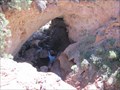
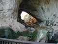
 view gallery view galleryS7.2 km |  Tonto Natural Bridge Tonto Natural Bridge
in Places of Geologic Significance The Tonto Natural Bridge is the world’s largest natural travertine bridge. An entrance fee is required. Pets are not allowed on the trails.
posted by: TerryDad2 location: Arizona date approved: 12/08/2007 last visited: 10/19/2019 |
 view gallery view galleryS7.2 km |  Tonto Natural Bridge State Park Tonto Natural Bridge State Park
in Scenic Hikes Tonto Natural Bridge State Park in Arizona has the largest diversity of wildlife in the state, with some of the most scenic landscape posted by: b.b.wolf location: Arizona date approved: 07/21/2009 last visited: 11/15/2015 |
 view gallery view galleryS7.2 km |  Tonto Natural Bridge Tonto Natural Bridge
in Natural Arches This is the largest natural travertine bridge in the world. posted by: TerryDad2 location: Arizona date approved: 12/09/2007 last visited: 10/19/2019 |
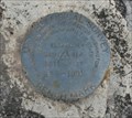
 view gallery view gallery NE8.9 km NE8.9 km
|  US Bureau of Public Roads 1955 US Bureau of Public Roads 1955
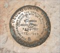
in U.S. Benchmarks A US Bureau of Public Roads benchmark along route 87 north of Pine, Arizona. posted by:  dcrep dcrep location: Arizona date approved: 07/06/2009 last visited: never |
 view gallery view galleryNE10.1 km |  Andres Moreno Gravesite Andres Moreno Gravesite
in Out of Place Graves The solitary grave of Andres Moreno alongside Rim Road near Strawberry, AZ. posted by: dcrep location: Arizona date approved: 04/08/2009 last visited: 07/30/2013 |
 view gallery view galleryNE10.5 km |  Mogollon Rim Fire Lookout Mogollon Rim Fire Lookout
in Look-Out Towers The Mogollon (MUGgy-own) Rim is a 200-mile long escarpment that marks the southern edge of the Colorado Plateau. The best views are from the fire lookout tower. posted by: TerryDad2 location: Arizona date approved: 10/04/2006 last visited: 07/23/2011 |
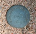
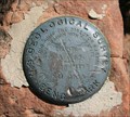
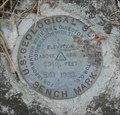
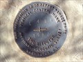 view gallery view gallerySE10.8 km | L496 1982 in U.S. Benchmarks L496 1982, an NGS vertical control marker posted by: tincanbits location: Arizona date approved: 02/28/2012 last visited: never |
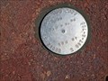
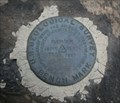 view gallery view galleryNE11.4 km | USGS R9 1933 in U.S. Benchmarks A US Geological Survey elevation benchmark along the Rim Road near Strawberry, Arizona. posted by: dcrep location: Arizona date approved: 04/08/2009 last visited: 08/08/2009 |
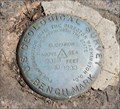 view gallery view galleryNE11.7 km | USGS R10 1933 in U.S. Benchmarks A USGS elevation benchmark found along the Rim Road near Strawberry, Arizona. posted by: dcrep location: Arizona date approved: 04/08/2009 last visited: never |
 view gallery view gallery E12.6 km E12.6 km
| USGS R11 1933 in U.S. Benchmarks A USGS elevation benchmark found along the Rim Road near Strawberry, Arizona. posted by: dcrep location: Arizona date approved: 05/31/2009 last visited: never |
 view gallery view gallerySE13.4 km | ADOT ROW 2009 - Payson, AZ in U.S. Benchmarks This Arizona Dept. of Transportation marker sits on a cliff overlooking the point where Hwy. 87 crosses the Verde River. posted by: rjmcdonough1 location: Arizona date approved: 09/02/2018 last visited: never |
 view gallery view galleryE16.1 km | USGS R13 1933 in U.S. Benchmarks A USGS elevation benchmark found along the Rim Road, near the Hi View Point of the Mogollon Rim, Arizona. posted by: dcrep location: Arizona date approved: 05/31/2009 last visited: 08/08/2009 |
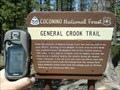 view gallery view galleryE16.1 km |  General Crook Trail General Crook Trail
in Wagon Roads and Trails This is the trail was created by under the direction of General George Crook. posted by: Flag_Mtn_Hkrs location: Arizona date approved: 06/06/2007 last visited: 10/17/2011 |
 view gallery view galleryNE16.7 km | USGS R55 1931 in U.S. Benchmarks A USGS elevation benchmark along route 87 near Pine, Arizona. posted by: dcrep location: Arizona date approved: 07/05/2009 last visited: never |
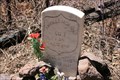
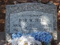 view gallery view gallerySE19 km |  Bob Hill - Carpenter - Payson, Arizona Bob Hill - Carpenter - Payson, Arizona
in Occupational/Hobby Grave Stones The tools of the trade are shown on his tombstone. posted by:  Tsegi Mike and Desert Viking Tsegi Mike and Desert Viking location: Arizona date approved: 08/26/2011 last visited: 06/20/2021 |
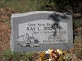 view gallery view gallerySE19.2 km | One Arm Brown - Truck Driver - Payson, Arizona in Occupational/Hobby Grave Stones A beloved father and friend who also drove a truck. posted by: Tsegi Mike and Desert Viking location: Arizona date approved: 08/26/2011 last visited: 08/27/2011 |
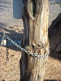 view gallery view gallerySE19.2 km |  Chain Eating Tree - Payson, Arizona Chain Eating Tree - Payson, Arizona
in Omnivorous Trees A chain around the chain keeps the gate shut, but a previous chain has been swallowed by the tree over time. posted by: Tsegi Mike and Desert Viking location: Arizona date approved: 09/10/2011 last visited: 05/21/2020 |
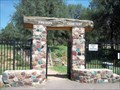 view gallery view gallerySE19.2 km |  Payson Pioneer Cemetery - Payson, Arizona, USA Payson Pioneer Cemetery - Payson, Arizona, USA
in Worldwide Cemeteries This old pioneer cemetery began in 1882 with one man. posted by: Tsegi Mike and Desert Viking location: Arizona date approved: 09/09/2011 last visited: 10/15/2011 |
 view gallery view galleryNE19.2 km | USGS R41 1933 in U.S. Benchmarks A USGS elevation benchmark between routes 87 and 141 on the Mogollon Rim in Arizona. posted by: dcrep location: Arizona date approved: 07/05/2009 last visited: never |
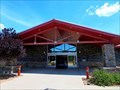 view gallery view gallerySE19.3 km |  Payson Public Library - Payson, AZ Payson Public Library - Payson, AZ
in Libraries This library, located in Rumsey Park, serves the Town of Payson. posted by: rjmcdonough1 location: Arizona date approved: 07/31/2018 last visited: never |
|