 view gallery view gallery N112.8 km N112.8 km
|   Santa Cruz County LIDAR #9 Santa Cruz County LIDAR #9
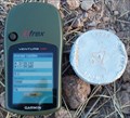
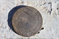
in U.S. Benchmarks Santa Cruz County Flood Control District flood map modernization project LIDAR Mapping Checkpoint #9. posted by:  Arizona Ranger Team Arizona Ranger Team location: Arizona date approved: 03/22/2011 last visited: never |
 view gallery view gallery NE118 km NE118 km
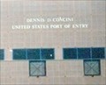
|  United States/Mexico on W. International Street - Nogales AZ United States/Mexico on W. International Street - Nogales AZ
in Border Crossings The Border Crossing in Nogales AZ is between the United States and Mexico. The crossing is on W. International Street near the end of Interstate I-19. posted by:  Don.Morfe Don.Morfe location: Arizona date approved: 04/25/2022 last visited: 04/23/2022 |
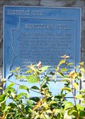 view gallery view galleryNE118.3 km |  Montezuma Hotel Montezuma Hotel
in Arizona Historical Markers The Montezuma Hotel, built in 1886, rebuilt twice, and closed in 1965, was the center of Nogales business and social life for more than half a century. posted by: leadhiker location: Arizona date approved: 05/04/2010 last visited: never |
 view gallery view galleryNE119.9 km | Camp Stephen D. Little in Arizona Historical Markers In late 1910, the U.S. Army established a permanent camp (later dedicated to fallen soldier Stephen D. Little) in Nogales, Arizona. posted by: leadhiker location: Arizona date approved: 06/25/2011 last visited: never |
 view gallery view galleryNE120.2 km | Grand Ave - Frank Reed School in Arizona Historical Markers Grand Ave. School was founded in 1928 as a grammar school, grades one through eight, for the African American children of Nogales. posted by: leadhiker location: Arizona date approved: 05/04/2010 last visited: never |
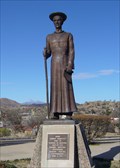 view gallery view galleryNE120.4 km |  Padre Eusebio Francisco Kino SJ - Nogales, AZ Padre Eusebio Francisco Kino SJ - Nogales, AZ
in Statues of Historic Figures Earliest pioneer of civilization in the southwest heroic missionary to the Pima Indians intrepid explorer founder of San Xavier del Bac. posted by: leadhiker location: Arizona date approved: 05/04/2010 last visited: 06/30/2018 |
 view gallery view galleryN132.1 km |  St. Ferdinand Mission Church - Arivaca, AZ St. Ferdinand Mission Church - Arivaca, AZ
in Roman Catholic Churches Gated mission church located along Arivaca Road. posted by: HiFiLZ location: Arizona date approved: 04/23/2008 last visited: 04/22/2008 |
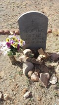 view gallery view galleryN132.3 km |  102 - Teofilo Ortiz, - Arivaca, Arizona 102 - Teofilo Ortiz, - Arivaca, Arizona
in Headstones of Centenarians A centenarian buried in a historic cemetery and town near the Mexican border. posted by: tugies location: Arizona date approved: 02/23/2017 last visited: 02/23/2017 |
 view gallery view galleryNE135.2 km | International Boundary and Water Commission in U.S. Benchmarks This marker is located on a hill approximately 200 feet north of the border between Mexico and the United States in Santa Cruz County, Arizona. posted by: outwest63 location: Arizona date approved: 01/17/2011 last visited: never |
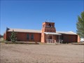
 view gallery view galleryNE135.3 km |  Lochiel Schoolhouse, Santa Cruz County, AZ Lochiel Schoolhouse, Santa Cruz County, AZ
in One-Room Schoolhouses One room adobe schoolhouse in southern Arizona near the Mexican border. posted by: tugies location: Arizona date approved: 10/17/2014 last visited: 12/31/2014 |
 view gallery view galleryNE137 km |  San Cayetano Top Hop San Cayetano Top Hop
in Summit Registers A summit Register for the second highest peak in the San Cayetano range. posted by: Phydux location: Arizona date approved: 06/14/2009 last visited: 05/10/2014 |
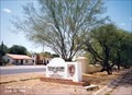
 view gallery view galleryN137.8 km |  Juan Bautista de Anza NHT - Tumacacori NHP Juan Bautista de Anza NHT - Tumacacori NHP
in NPS Passport Cancellation Stations A stop on the Juan Bautista de Anza NHT. This stop is also a National Historic Park. The stamp is in the visitor center. posted by: npsVisitor location: Arizona date approved: 03/17/2019 last visited: 03/05/2023 |
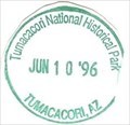 view gallery view galleryN137.8 km | Tumacacori National Historic Park - Tumacacori, AZ in NPS Passport Cancellation Stations Tumacácori sits at a cultural crossroads in the Santa Cruz River valley. Here O’odham, Yaqui, and Apache people met and mingled with European Jesuit and Franciscan missionaries, settlers, and soldiers, sometimes in conflict and sometimes in cooperation. posted by: Don.Morfe location: Arizona date approved: 02/14/2020 last visited: 03/05/2023 |
 view gallery view galleryN137.8 km |  Tumacácori National Historical Park - Tumacacori, AZ Tumacácori National Historical Park - Tumacacori, AZ
in Wikipedia Entries Tumacácori National Historical Park is located in the upper Santa Cruz River Valley in Santa Cruz County, southern Arizona. The park consists of 360 acres (1.5 km2) in three separate units. posted by: Don.Morfe location: Arizona date approved: 02/19/2022 last visited: 02/20/2022 |
 view gallery view galleryN137.8 km |  Tumacácori National Historical Park - Tumacacori, AZ Tumacácori National Historical Park - Tumacacori, AZ
in U.S. National Register of Historic Places Tumacácori National Historical Park is located in the upper Santa Cruz River Valley in Santa Cruz County, southern Arizona. The park consists of 360 acres (1.5 km2) in three separate units. posted by: Don.Morfe location: Arizona date approved: 02/20/2022 last visited: 02/20/2022 |
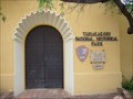
 view gallery view galleryN137.8 km |  Tumacácori National Historical Park - Tumacacori, AZ Tumacácori National Historical Park - Tumacacori, AZ
in Ranger Stations The Ranger Station is inside the Visitor Center. The Mission San José de Tumacácori complex is open to the public. Nearby are the park's visitor center and the Tumacácori Museum in a historic Mission Revival style building. posted by: Don.Morfe location: Arizona date approved: 03/06/2022 last visited: 02/20/2022 |
 view gallery view galleryN137.8 km |  Tumacácori National Historical Park - Tumacacori, AZ Tumacácori National Historical Park - Tumacacori, AZ
in National Parks of the World Tumacácori National Historical Park is located in the upper Santa Cruz River Valley in Santa Cruz County, southern Arizona. The park consists of 360 acres (1.5 km2) in three separate units. posted by: Don.Morfe location: Arizona date approved: 02/20/2022 last visited: 02/20/2022 |
 view gallery view galleryN137.8 km |  Tumacácori National Historical Park - Tumacacori, AZ Tumacácori National Historical Park - Tumacacori, AZ
in Official Local Tourism Attractions Tumacácori National Historical Park is located in the upper Santa Cruz River Valley in Santa Cruz County, southern Arizona. The park consists of 360 acres (1.5 km2) in three separate units. posted by: Don.Morfe location: Arizona date approved: 02/19/2022 last visited: 02/20/2022 |
 view gallery view galleryN137.8 km | ") Tumacácori National Historical Park Tumacácori National Historical Park
in National Parks (U.S.) Tumacácori NHP protects three Spanish colonial mission ruins in southern Arizona posted by: leadhiker location: Arizona date approved: 11/22/2009 last visited: 02/20/2022 |
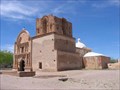 view gallery view galleryN137.8 km | Mission San José de Tumacácori (Franciscan) - Tumacácori, AZ in Roman Catholic Churches Historic Mission ruins located approximately 40 miles south of Tucson on I-19. posted by: HiFiLZ location: Arizona date approved: 04/18/2008 last visited: 02/11/2012 |
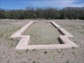 view gallery view galleryN137.9 km | Mission San José de Tumacácori (Jesuit) - Tumacácori, AZ in Roman Catholic Churches Preserved rock foundation of the Jesuit church at Mission San José de Tumacácori. posted by: HiFiLZ location: Arizona date approved: 04/18/2008 last visited: 02/11/2012 |
 view gallery view galleryN142.1 km | Tubac in Arizona Historical Markers The Art Colony of Tubac was established in 1752 as a Spanish presidio (fort). Working artists' studios now surround the grounds which once served as the home for a Spanish military garrison. posted by: leadhiker location: Arizona date approved: 05/03/2010 last visited: 09/30/2023 |
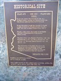
 view gallery view galleryNE142.1 km | John Ward's Ranch in Arizona Historical Markers On January 27, 1861, Indians raided John Ward's ranch on Sonoita Creek, abducting Ward's stepson and stealing cattle.
The incident ignited a war that would not be resolved until 1872. posted by: leadhiker location: Arizona date approved: 05/04/2010 last visited: 03/21/2018 |
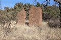 view gallery view galleryNE142.4 km |  Harshaw, Az. - Ghost Town Harshaw, Az. - Ghost Town
in Ghost Towns Harshaw is located South of Patagonia, Az. Harshaw was an active mining community from 1877 to 1903. posted by: outwest63 location: Arizona date approved: 10/14/2013 last visited: never |
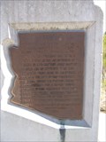
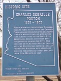 view gallery view galleryN142.4 km | Charles Debrille Poston in Arizona Historical Markers Charles Debrille Poston was an American explorer, prospector, author, politician, and civil servant. He is referred to as the "Father of Arizona" due to his efforts lobbying for creation of the territory. posted by: leadhiker location: Arizona date approved: 05/06/2010 last visited: 09/30/2023 |
|