 view gallery view gallery SW2.3 km SW2.3 km
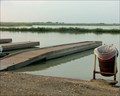
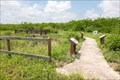
|   San Martin Lake Boat Ramp, Brownsville, Texas San Martin Lake Boat Ramp, Brownsville, Texas
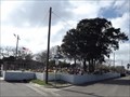
in Boat Ramps This two-lane boat ramp on San Martin Lake off of Texas Route 48 is used by shallow-draft boats (power and non-power) to access the estuaries and bays between Brownsville and Port Isabel. It's open 24/7.
posted by:  JimmyEv JimmyEv location: Texas date approved: 12/29/2007 last visited: 10/27/2023 |
 view gallery view gallery S6.3 km S6.3 km
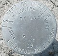
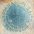
|  USDI F&WS TR209 2000 19, TX USDI F&WS TR209 2000 19, TX
in U.S. Benchmarks Located along Hwy 4 east of Brownsville, TX posted by:  8Nuts MotherGoose 8Nuts MotherGoose location: Texas date approved: 07/27/2010 last visited: 02/01/2014 |
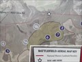
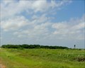 view gallery view galleryS6.4 km |  Palmito Ranch Battlefield, Brownsville, Texas Palmito Ranch Battlefield, Brownsville, Texas
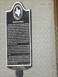
in U.S. National Register of Historic Places With severe weather and shifting sands, the tidal flats east of Brownsville were never developed. This has left most of the Palmito Ranch Battlefield, the last land battle of the Civil War, intact with only the course of the Rio Grande changing. posted by: JimmyEv location: Texas date approved: 12/29/2007 last visited: 05/11/2023 |
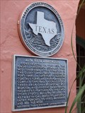
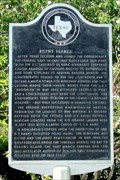
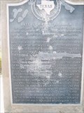 view gallery view galleryS6.4 km |  Battle of Palmito Ranch Battle of Palmito Ranch
in Texas Historical Markers The last land battle of the Civil War occurred here. posted by: 8Nuts MotherGoose location: Texas date approved: 04/27/2007 last visited: 05/12/2023 |
 view gallery view galleryS6.4 km | A776, AB0063, Hwy 4, Brownsville, TX in U.S. Benchmarks Located near a Historical Marker and a Geocache on Hwy 4. posted by: 8Nuts MotherGoose location: Texas date approved: 07/27/2010 last visited: 02/01/2014 |
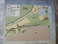 view gallery view galleryS6.4 km |  'You are Here' - Secluded Beaches, Dunes & Wildlife - Boca Chica TX 'You are Here' - Secluded Beaches, Dunes & Wildlife - Boca Chica TX
in 'You Are Here' Maps This 'You Are Here' Map is on Boca Chica Boulevard (Texas Hwy 4) about 4 miles east of Brownsville, Texas and just west of the Boca Chica WMA. posted by: PeterNoG location: Texas date approved: 05/14/2014 last visited: 05/11/2023 |
 view gallery view galleryS6.4 km | 'You are Here' - Palmito Ranch Battlefield - Brownsville TX in 'You Are Here' Maps This 'You Are Here' Map is on Boca Chica Boulevard (Texas Hwy 4) about 4 miles east of Brownsville, Texas. posted by: PeterNoG location: Texas date approved: 05/14/2014 last visited: 05/11/2023 |
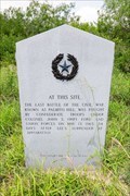 view gallery view galleryS6.6 km | Last Battle of the Civil War in Texas Historical Markers This marker is tucked away off the highway at a small interpretive site for the Battle of Palmito Hill, which is considered to be the last battle of the Civil War. It's located near the north end of Palmito Hill Road near Brownsville, Texas. posted by: The A-Team location: Texas date approved: 09/30/2023 last visited: never |
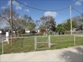
 view gallery view galleryS6.6 km |  Battle of Palmito Hill - Brownsville, Texas Battle of Palmito Hill - Brownsville, Texas
in Battlefields A small interpretive site for the Battle of Palmito Hill, which is considered to be the last battle of the Civil War, is tucked away off the highway. It's located near the north end of Palmito Hill Road near Brownsville, Texas. posted by: The A-Team location: Texas date approved: 09/30/2023 last visited: never |
 view gallery view galleryS7.9 km |  Texas Tortoise - Brownsville, Texas Texas Tortoise - Brownsville, Texas
in Turtle Crossings This Texas tortoise was crossing Palmito Hill Road east of Brownsville, Texas. posted by: The A-Team location: Texas date approved: 10/08/2023 last visited: never |
 view gallery view gallery SE8 km SE8 km
| Camp Belknap in Texas Historical Markers Story of an Army camp during the Mexican American War. posted by: 8Nuts MotherGoose location: Texas date approved: 04/28/2007 last visited: 10/27/2023 |
 view gallery view gallery NE8.4 km NE8.4 km
|  Jack in the Box - State Highway 100 - Port Isabel, Texas Jack in the Box - State Highway 100 - Port Isabel, Texas
in Jack In The Box This Jack in the Box is located at 1681 State Highway 100 on the west side of Port Isabel, Texas. posted by: The A-Team location: Texas date approved: 10/12/2023 last visited: never |
 view gallery view gallery N8.5 km N8.5 km
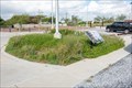
|  South Texas Ecotourism Center Butterfly Garden - Laguna Vista, TX South Texas Ecotourism Center Butterfly Garden - Laguna Vista, TX
in Butterfly Gardens A butterfly garden was planted beside the parking lot of the South Texas Ecotourism Center in Laguna Vista, TX. posted by: The A-Team location: Texas date approved: 01/21/2024 last visited: never |
 view gallery view galleryNE8.7 km |  Laguna Madre Water District Water Tower - Port Isabel TX Laguna Madre Water District Water Tower - Port Isabel TX
in Water Towers This Water Tower is on Port Road just south of Texas Hwy 100 in Port Isabel, Texas. posted by: PeterNoG location: Texas date approved: 05/08/2014 last visited: 10/28/2023 |
 view gallery view galleryNE8.9 km |  Santa Isabel Cemetery - Port Isabel TX Santa Isabel Cemetery - Port Isabel TX
in Worldwide Cemeteries This Cemetery is on the east side of Island Avenue, 220 feet north of Texas Hwy 100 in Port Isabel, Texas. posted by: PeterNoG location: Texas date approved: 02/22/2014 last visited: 10/29/2023 |
 view gallery view galleryNE9.7 km | Alta Vista Apartments in Texas Historical Markers This Texas Historical Marker is mounted on the Alta Vista Apartments at 700 Polk Street in Port Isabel, Texas. posted by: PeterNoG location: Texas date approved: 03/15/2014 last visited: 01/31/2014 |
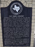 view gallery view galleryNE9.8 km | Port Isabel Cemetery in Texas Historical Markers This Texas Historical Marker is in the Port Isabel Cemetery on Harborlight Street at Houston Street in Port Isabel, Texas. posted by: PeterNoG location: Texas date approved: 03/15/2014 last visited: 01/31/2014 |
 view gallery view galleryNE9.8 km | Port Isabel Cemetery - Port Isabel TX in Worldwide Cemeteries This Cemetery is on Harborlight Street at Houston Street in Port Isabel, Texas. posted by: PeterNoG location: Texas date approved: 02/22/2014 last visited: 01/31/2014 |
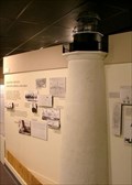
 view gallery view galleryNE10.1 km |  Treasures of the Gulf Museum, Port Isabel, Texas Treasures of the Gulf Museum, Port Isabel, Texas
in History Museums Three Spanish ships sank off the coast of Padre Island in the 16th century. Their remains, and lots of other cool stuff related to primitive sea travel, are displayed here. posted by: JimmyEv location: Texas date approved: 03/08/2008 last visited: 10/27/2023 |
 view gallery view galleryNE10.1 km | Port Isabel Historic Museum, Port Isabel, Texas in History Museums A few surprises await you at Port Isabel’s rather comprehensive history museum - one of the best in the Valley. posted by: JimmyEv location: Texas date approved: 03/08/2008 last visited: 10/27/2023 |
 view gallery view galleryNE10.1 km | Charles Champion in Texas Historical Markers This Texas Historical Marker is beside the former Champion Building, now the Port Isabel Historical Museum at 317 East Railroad Street in Port Isabel, Texas. posted by: PeterNoG location: Texas date approved: 01/24/2014 last visited: 10/27/2023 |
 view gallery view galleryNE10.1 km | Point Isabel, C.S.A. in Texas Historical Markers The port at Point Isabel was virtually abandoned during the Federal blockade of the Civil War. posted by: JimmyEv location: Texas date approved: 11/21/2007 last visited: 10/27/2023 |
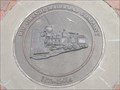 view gallery view galleryNE10.1 km |  Rio Grande Railroad Company - Port Isabel TX Rio Grande Railroad Company - Port Isabel TX
in Unique Manhole Covers This Unique Manhole Cover is on the south corner of East Railroad Avenue and South Tarnava Street in Port Isabel, Texas posted by: PeterNoG location: Texas date approved: 01/11/2014 last visited: 10/27/2023 |
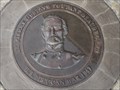
 view gallery view galleryNE10.1 km | Lt. Ulysses S. Grant - Port Isabel TX in Unique Manhole Covers This Unique Manhole Cover is on the west corner of East Railroad Avenue and South Tarnava Street in Port Isabel, Texas posted by: PeterNoG location: Texas date approved: 01/22/2014 last visited: 10/27/2023 |
 view gallery view galleryNE10.1 km | Lt. Pierre Gustave Toutant Beaurgard - Port Isabel TX in Unique Manhole Covers This Unique Manhole Cover is on the north corner of East Railroad Avenue and South Tarnava Street in Port Isabel, Texas posted by: PeterNoG location: Texas date approved: 01/22/2014 last visited: 10/27/2023 |
|