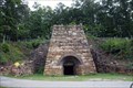
 view gallery view gallery SE1.8 km SE1.8 km
|   Janney Furnace - Ohatchee, Alabama Janney Furnace - Ohatchee, Alabama
in Iron Furnace Ruins The furnace was constructed by Montgomery businessman Alfred A. Janney. Located on Janney Road 0.1 miles east of Spring Road, Ohatchee, Alabama. posted by:  Lat34North Lat34North location: Alabama date approved: 08/29/2012 last visited: 01/08/2013 |
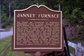 view gallery view gallerySE1.8 km |  Janney Furnace - Ohatchee, Alabama Janney Furnace - Ohatchee, Alabama
in Alabama Historical Markers The furnace was constructed by Montgomery businessman Alfred A. Janney. Located on Janney Road 0.1 miles east of Spring Road, Ohatchee, Alabama' posted by: Lat34North location: Alabama date approved: 08/21/2012 last visited: 01/08/2013 |
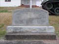
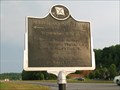
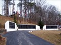 view gallery view gallerySE1.8 km |  Calhoun County Confederate Memorial - Ohatchee, AL Calhoun County Confederate Memorial - Ohatchee, AL
in American Civil War Monuments and Memorials The Calhoun County Confederate Memorial is located at Janney Furnace Confederate Park on Janney Road. posted by:  hummerstation hummerstation location: Alabama date approved: 02/11/2013 last visited: never |
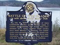 view gallery view gallery SW3.2 km SW3.2 km
| Battle of "Ten Islands" - Ohatchee, AL in Alabama Historical Markers The Battle of "Ten Islands" historical marker commemorates a July 14, 1864 Civil War battle. posted by: hummerstation location: Alabama date approved: 01/10/2013 last visited: never |
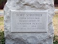 view gallery view gallerySW3.5 km | Fort Strother - Ohatchee, AL in Alabama Historical Markers Fort Strother was the Creek Indian War Headquarters of Gen. Andrew Jackson. posted by: hummerstation location: Alabama date approved: 01/10/2013 last visited: never |
 view gallery view gallery E9.8 km E9.8 km
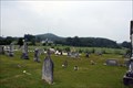
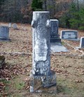
|  Crook Cemetery - Alexandria, AL Crook Cemetery - Alexandria, AL
in Worldwide Cemeteries James Crook established this cemetery in 1837 on land he purchased from Creek Indian. Located at the cemetery on McCullars Lane west of County Road 73, Alexandria, Alabama. posted by: Lat34North location: Alabama date approved: 08/20/2012 last visited: 08/15/2012 |
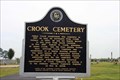 view gallery view galleryE9.8 km | Crook Cemetery - Alexandria, AL in Alabama Historical Markers James Crook established this cemetery in 1837 on land he purchased from Creek Indian. Located at the cemetery on McCullars Lane west of County Road 73, Alexandria, Alabama. posted by: Lat34North location: Alabama date approved: 08/17/2012 last visited: 08/15/2012 |
 view gallery view galleryE10.5 km | Lincoyer and The Battle of Tallasehatchee - Alexandria, Alabama in Alabama Historical Markers Site where Lincoyer was found and saved by Gen. Andrew Jackson after the Battle of Talluschatches. Located on McCullars Lane west of County Road 73, Alexandria, Alabama. posted by: Lat34North location: Alabama date approved: 08/19/2012 last visited: 08/15/2012 |
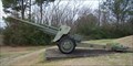
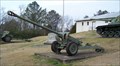 view gallery view gallerySW10.6 km |  T124 E2 76mm Antitank Gun - Ragland, AL T124 E2 76mm Antitank Gun - Ragland, AL
in Static Artillery Displays T124 E2 76mm Antitank Gun displayed in front of VFW Post 6652 in Ragland, AL. posted by: hummerstation location: Alabama date approved: 01/11/2013 last visited: never |
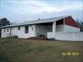 view gallery view gallerySW10.6 km |  Post 6652 - Ragland, AL Post 6652 - Ragland, AL
in VFW Posts VFW Post #6652 sits on a hill overlooking AL Hwy 144 on the east side of Ragland. posted by: hummerstation location: Alabama date approved: 01/14/2013 last visited: never |
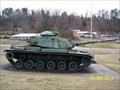 view gallery view gallerySW10.6 km |  M60A3 Main Batle Tank - Ragland, AL M60A3 Main Batle Tank - Ragland, AL
in Military Ground Equipment Displays M60A3 Main Battle Tank displayed in front of VFW Post 6652 in Ragland, AL. posted by: hummerstation location: Alabama date approved: 01/09/2013 last visited: never |
 view gallery view gallerySW10.6 km |  Ragland Veterans Memorial - Ragland, AL Ragland Veterans Memorial - Ragland, AL
in Non-Specific Veteran Memorials The Ragland Veterans Memorial is located on AL Hwy 144. posted by: hummerstation location: Alabama date approved: 01/19/2013 last visited: never |
 view gallery view gallerySW10.6 km | 90mm T8 Antitank Gun - Ragland, AL in Static Artillery Displays 90mm T8 Antitank Gun displayed at VFW Post #6652 in Ragland, AL. posted by: hummerstation location: Alabama date approved: 01/19/2013 last visited: never |
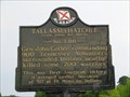 view gallery view galleryE12.2 km | Tallasseehatchee in Alabama Historical Markers Tallasseehatchee
Creek Indian War 1813-14, November 3, 1813. General John Coffee, commanding 900 Tennessee Volunteers, surrounded the Indians nearby and killed some 200 warriors. This was the first American victory of the war. It avenged the earlier massacre of 517 at Ft. Mims by Indians.
posted by: Thorny1 location: Alabama date approved: 07/03/2008 last visited: 08/15/2012 |
 view gallery view gallery N12.9 km N12.9 km
|  Subway # 32480 - AL 77 - Gadsden, AL Subway # 32480 - AL 77 - Gadsden, AL
in Subway Restaurants This Subway is located on Alabama Highway 77 in (Southside) Gadsden, AL. posted by: Lat34North location: Alabama date approved: 08/22/2012 last visited: 08/15/2012 |
 view gallery view galleryN13.5 km |  McDonald's - Grub Mart - AL 77 - Gadsden, AL McDonald's - Grub Mart - AL 77 - Gadsden, AL
in Wi-Fi Hotspots This McDonald's is co-located with the Grub Mart on Alabama State Road 77 in Gadsden, AL. posted by: Lat34North location: Alabama date approved: 08/23/2012 last visited: 08/15/2012 |
 view gallery view galleryN13.5 km |  McDonald's - Grub Mart - AL 77 - Gadsden, AL McDonald's - Grub Mart - AL 77 - Gadsden, AL
in McDonald's Restaurants This McDonald's is co-located with the Grub Mart on Alabama State Road 77 in Gadsden, AL. posted by: Lat34North location: Alabama date approved: 08/24/2012 last visited: 08/15/2012 |
 view gallery view galleryE13.8 km | Subway # 28783 - US 431 - Alexanderia, AL in Subway Restaurants This free standing subway is located on U.S. 431, Alexandria, AL. posted by: Lat34North location: Alabama date approved: 08/17/2012 last visited: 08/15/2012 |
 view gallery view gallery W14.5 km W14.5 km
|  John Looney House - Ashville, AL John Looney House - Ashville, AL
in Homesteads John Looney House, Ashville, AL posted by: hummerstation location: Alabama date approved: 12/13/2011 last visited: never |
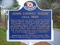 view gallery view galleryW14.5 km | John Looney House circa 1820 - Ashville, AL in Alabama Historical Markers John Looney House circa 1820, Ashville, AL posted by: hummerstation location: Alabama date approved: 11/19/2011 last visited: never |
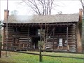 view gallery view galleryW14.5 km |  Looney House - Ashville, AL Looney House - Ashville, AL
in U.S. National Register of Historic Places Looney House, Ashville, AL posted by: hummerstation location: Alabama date approved: 11/29/2011 last visited: 08/16/2014 |
 view gallery view gallerySE16.6 km | Major John Pelham in Alabama Historical Markers Major John Pelham was born here Sept 7, 1838 posted by: Thorny1 location: Alabama date approved: 07/03/2008 last visited: 08/15/2012 |
 view gallery view gallery S17.7 km S17.7 km
| Refuge Baptist Church Cemetery - Lincoln, AL in Worldwide Cemeteries Refuge Baptist Church Cemetery is an old cemetery located on a small country road. posted by: hummerstation location: Alabama date approved: 12/14/2012 last visited: never |
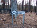 view gallery view galleryS17.7 km |  Refuge Baptist Church Cemetery - Lincoln, AL Refuge Baptist Church Cemetery - Lincoln, AL
in Abandoned Cemeteries Refuge Baptist Church Cemetery is an old cemetery located on Brooks Lake Road. posted by: hummerstation location: Alabama date approved: 12/17/2012 last visited: never |
 view gallery view gallerySW18.5 km |  Delma L. Bell - Lincoln, AL Delma L. Bell - Lincoln, AL
in Woodmen of the World Grave Markers/Monuments The Delma L. Bell Woodmen of the World marker is located in Halls Cemetery in Lincoln, AL. posted by: hummerstation location: Alabama date approved: 12/13/2012 last visited: never |
|