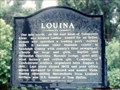
 view gallery view gallery S9.3 km S9.3 km
|   Louina Louina
in Alabama Historical Markers On AL 22 just east of the Tallapoosa River bridge. posted by:  Markerman62 Markerman62 location: Alabama date approved: 03/22/2015 last visited: 03/11/2015 |
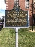 view gallery view gallery NE15.4 km NE15.4 km
| Randolph County in Alabama Historical Markers Located in front of the Randolph County Courthouse. posted by: flyingmoose location: Alabama date approved: 12/18/2021 last visited: 01/11/2022 |
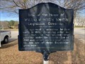 view gallery view galleryNE15.4 km | Site of the Home of William Hugh Smith Legislator, Governor - Wedowee, AL in Alabama Historical Markers Located in the median of US 431 near Woodland Avenue, Wedowee posted by: Markerman62 location: Alabama date approved: 03/30/2022 last visited: never |
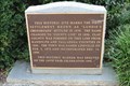
 view gallery view galleryS17.1 km | Daviston, Alabama - Daviston, AL in Alabama Historical Markers Daviston, Alabama, incorporated February 16, 1887, is believed to be the first incorporated rural town in Tallapoosa County. posted by: hummerstation location: Alabama date approved: 02/25/2016 last visited: never |
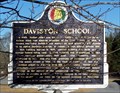 view gallery view galleryS17.1 km | Daviston School - Daviston, AL in Alabama Historical Markers At the time of its closing in 1988 Daviston School was the smallest school in Alabama with 120 K-12 students. posted by: hummerstation location: Alabama date approved: 02/25/2016 last visited: never |
 view gallery view gallery NW20.1 km NW20.1 km
|  Site of Lundie's Crossroads -- Lineville AL Site of Lundie's Crossroads -- Lineville AL
in Signs of History This sign of history preserves the memory of Lundie's Crossroads, a precursor to modern-day Lineville AL posted by: Benchmark Blasterz location: Alabama date approved: 09/02/2017 last visited: 07/27/2017 |
 view gallery view galleryNW20.1 km |  Incorporation of Lineville - 100 Years - Lineville, AL Incorporation of Lineville - 100 Years - Lineville, AL
in Commercial Commemorations This sign of history preserves the memory of Lundie's Crossroads, a precursor to modern-day Lineville AL, and celebrates Lineville's centennial of incorporation as a city posted by: Benchmark Blasterz location: Alabama date approved: 09/06/2017 last visited: 07/26/2017 |
 view gallery view galleryNW20.1 km |  FIRST -- White settlers in the area, Lineville AL FIRST -- White settlers in the area, Lineville AL
in First of its Kind The first white settlers in what would become Lineville were brothers William and Thomas Lundie. posted by: Benchmark Blasterz location: Alabama date approved: 09/01/2017 last visited: 07/27/2017 |
 view gallery view galleryNW20.1 km | FIRST -- Mayor of Lineville, Lineville AL in First of its Kind The first Mayor of Lineville, H. J. Willingham, was appointed in 1891. posted by: Benchmark Blasterz location: Alabama date approved: 09/01/2017 last visited: 07/27/2017 |
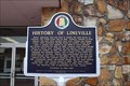
 view gallery view galleryNW20.1 km | History of Lineville -- Lineville AL in Alabama Historical Markers The state historic marker in front of Lineville City Hall in Lineville AL posted by: Benchmark Blasterz location: Alabama date approved: 09/07/2017 last visited: 07/28/2017 |
 view gallery view gallery E20.3 km E20.3 km
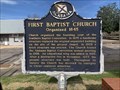
| First Baptist Church Organized 1845 - Roanoke, AL in Alabama Historical Markers Located on Main Street and Church Street, Roanoke posted by: Markerman62 location: Alabama date approved: 03/30/2022 last visited: never |
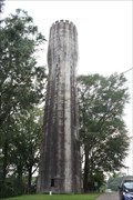 view gallery view galleryNW20.3 km |  Lineville Water Tower -- Lineville AL Lineville Water Tower -- Lineville AL
in Water Towers The historic Lineville Water Tower is on the Alabama Register of Landmarks and Heritage. posted by: Benchmark Blasterz location: Alabama date approved: 09/02/2017 last visited: 07/27/2017 |
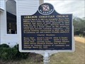 view gallery view galleryE21.7 km | Lebanon Christian Church - Roanoke, AL in Alabama Historical Markers Located on CR 79 at CR 667 and CR 670, Roanoke posted by: Markerman62 location: Alabama date approved: 03/30/2022 last visited: never |
 view gallery view galleryE21.7 km | Lebanon Christian Church Cemetery - Roanoke, AL in Alabama Historical Markers Located on CR 79 at CR 667 and CR 670, Roanoke posted by: Markerman62 location: Alabama date approved: 03/30/2022 last visited: never |
 view gallery view gallery W24.1 km W24.1 km
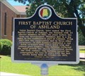
| First Baptist Church of Ashland - Ashland, AL in Alabama Historical Markers Located on 1st Ave. just north of 5th St. notes the founding of the church and its subsequent buildings used by the congregation. posted by:  hoteltwo hoteltwo location: Alabama date approved: 06/21/2016 last visited: never |
 view gallery view galleryW24.8 km |  Clay County Courthouse - Ashland, AL Clay County Courthouse - Ashland, AL
in U.S. National Register of Historic Places Clay County Courthouse posted by: wmize location: Alabama date approved: 05/16/2011 last visited: 07/12/2012 |
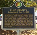 view gallery view galleryW24.8 km | Clay County - Ashland, Alabama in Alabama Historical Markers Located on the grounds of the Clay County Courthouse near Court Square and 2nd Avenue. It describes how Clay County was formed and its historical place names within the county. posted by: hoteltwo location: Alabama date approved: 06/25/2016 last visited: never |
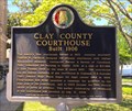 view gallery view galleryW24.8 km | Clay County Courthouse - Ashland, AL in Alabama Historical Markers Marker located on the grounds of the Clay County courthouse at Court Square notes the history of the courthouse and famous county politicians. posted by: hoteltwo location: Alabama date approved: 06/25/2016 last visited: never |
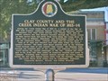
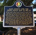 view gallery view galleryW24.9 km | Clay County and the Creek Indian War of 1813-14 - Ashland, AL in Alabama Historical Markers Located on the grounds of the Clay County Courthouse notes the trails and areas of the future Clay County used in the Creek Indian wars of 1813-1814. posted by: hoteltwo location: Alabama date approved: 06/21/2016 last visited: never |
 view gallery view galleryW24.9 km | Clay County and the Creek Indian Confederacy - Ashland, AL in Alabama Historical Markers Located on the lawn of the Clay County Courthouse explains the importance of Clay County area on the Creek Indian confederacy, the trails and lands used by the Creeks and the treaties involved. posted by: hoteltwo location: Alabama date approved: 06/25/2016 last visited: 01/23/2023 |
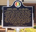 view gallery view galleryW24.9 km | Ashland, Alabama in Alabama Historical Markers Marker located in front of the Ashland City Hall notes the early and current history of the city. posted by: hoteltwo location: Alabama date approved: 06/25/2016 last visited: never |
 view gallery view gallery SW25.4 km SW25.4 km
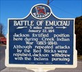
| Battle of Emucfau - New Site, AL in Alabama Historical Markers The Battle of Emucfau occurred January 22, 1814. posted by: hummerstation location: Alabama date approved: 02/25/2016 last visited: 07/27/2017 |
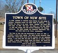 view gallery view gallerySW25.7 km | Town of New Site - New Site, AL in Alabama Historical Markers The Town of New Site was incorporated on August 23, 1965, to establish a public water system. posted by: hummerstation location: Alabama date approved: 02/25/2016 last visited: 07/27/2017 |
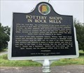 view gallery view galleryE27.2 km | Pottery Shops in Rock Mills - Rock Mills, AL in Alabama Historical Markers Located on CR 91 at CR 2206, this marker notes the many potteries established in the area and the wares produced. posted by: hoteltwo location: Alabama date approved: 07/20/2018 last visited: never |
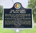 view gallery view galleryE27.2 km | The Potters of Rock Mills - Rock Mills, AL in Alabama Historical Markers Located on CR 91 at CR 2206, this two-sided marker notes the many families and potteries established in the area and the wares produced. posted by: hoteltwo location: Alabama date approved: 07/20/2018 last visited: never |
|