 view gallery view gallery W2.3 km W2.3 km
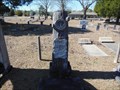
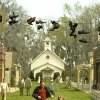
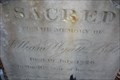
|   H. B. Bazzell - Pine Level Cemetery - Prattville, AL H. B. Bazzell - Pine Level Cemetery - Prattville, AL
in Woodmen of the World Grave Markers/Monuments H. B. Bazzell was born on February 18, 1875 and died on October 8, 1915. posted by:  xptwo xptwo location: Alabama date approved: 06/09/2013 last visited: never |
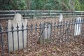
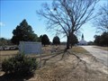 view gallery view galleryW2.3 km |  Pine Level United Methodist Church Cemetery - Prattville, AL Pine Level United Methodist Church Cemetery - Prattville, AL
in Churchyard Cemeteries Pine Level United Methodist Church Cemetery has graves dating to the 1800s. posted by: xptwo location: Alabama date approved: 02/16/2013 last visited: never |
 view gallery view gallery NE3.7 km NE3.7 km
| Deatsville Cemetery - Deatsville, Alabama in Churchyard Cemeteries Deatsville Cemetery, Deatsville, Alabama posted by: hummerstation location: Alabama date approved: 04/30/2010 last visited: 08/04/2011 |
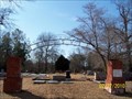 view gallery view galleryNE3.7 km |  Deatsville Cemetery Arch - Deatsville, Alabama Deatsville Cemetery Arch - Deatsville, Alabama
in Freestanding Arches Deatsville Cemetery Arch, Deatsville, Alabama posted by: hummerstation location: Alabama date approved: 03/01/2010 last visited: 08/04/2011 |
 view gallery view galleryNE3.7 km |  Sanctuary Windows - Deatsville Chapel, Deatsville, Alabama USA Sanctuary Windows - Deatsville Chapel, Deatsville, Alabama USA
in Stained Glass Windows Sanctuary Windows - Deatsville Chapel, Deatsville, Alabama USA posted by: hummerstation location: Alabama date approved: 02/28/2010 last visited: 08/04/2011 |
 view gallery view galleryNE3.7 km |  Deatsville Cemetery - Deatsville, Alabama Deatsville Cemetery - Deatsville, Alabama
in Worldwide Cemeteries Deatsville Cemetery, Deatsville, Alabama posted by: hummerstation location: Alabama date approved: 03/01/2010 last visited: 08/04/2011 |
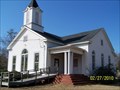 view gallery view galleryNE3.7 km |  Deatsville Chapel - Deatsville, Alabama Deatsville Chapel - Deatsville, Alabama
in Methodist Churches Deatsville Chapel, Deatsville, Alabama posted by: hummerstation location: Alabama date approved: 03/01/2010 last visited: 08/04/2011 |
 view gallery view gallery N6.9 km N6.9 km
|  Pine Flat Presbyterian Church - Big Fish Pine Flat Presbyterian Church - Big Fish
in Movie Locations Pine Flat Presbyterian Church was the filming location for the town of Spectre in Tim Burton's 2003 film Big Fish. posted by: OHail location: Alabama date approved: 05/17/2012 last visited: never |
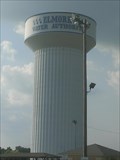 view gallery view gallery SE7.2 km SE7.2 km
|  Millbrook Water Authority (Roy) Millbrook Water Authority (Roy)
in Water Towers This Water Tower sits atop a hill looming over Millbrook’s Legacy Park situated along Hwy 7 – the Deatsville Highway. The tower itself is easily recognizable as one drives by. posted by: j1srus location: Alabama date approved: 09/01/2013 last visited: never |
 view gallery view galleryNE7.2 km | West Holtville Alabama Water Tank in Water Towers Fairly new water tower far out in the country. posted by: HotRod205 location: Alabama date approved: 09/12/2010 last visited: 08/04/2011 |
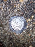
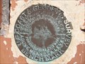 view gallery view galleryNE7.6 km |  Opelika Depot CM0652 - Opelika, AL Opelika Depot CM0652 - Opelika, AL
in U.S. Benchmarks This benchmark is embedded in the wall on the track side of the old Opelika Depot, which has been restored and is used by The Arts Association of East Alabama. posted by: xptwo location: Alabama date approved: 07/24/2013 last visited: never |
 view gallery view gallery S9.7 km S9.7 km
| CN3270 - Prattville, AL in U.S. Benchmarks This mark is located on U.S. Highway 31 north of Prattville, Alabama. It is located on the east side of the road. posted by: xptwo location: Alabama date approved: 11/23/2012 last visited: never |
 view gallery view gallery NW9.7 km NW9.7 km
| C-497 Benchmark - Marbury, AL in U.S. Benchmarks The C-497 Benchmark is located at the north east corner of the CR 68 bridge over I-65. posted by: hummerstation location: Alabama date approved: 02/07/2016 last visited: never |
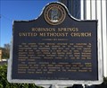 view gallery view gallerySE10 km |  Robinson Springs United Methodist Church - Millbrook, AL Robinson Springs United Methodist Church - Millbrook, AL
in Alabama Historical Markers Historic church, placed on the National Register of Historic Places in 1982, is located on Main Street in Millbrook. posted by:  hoteltwo hoteltwo location: Alabama date approved: 01/08/2014 last visited: never |
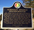 view gallery view gallerySE10 km | Robinson Springs Neighborhood - Millbrook, AL in Alabama Historical Markers History of the community Robinson Springs within Millbrook. Marker is located on Monument Drive near Confederate Memorial Park. posted by: hoteltwo location: Alabama date approved: 01/08/2014 last visited: 06/29/2021 |
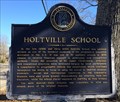 view gallery view galleryNE11.1 km | Holtville School - Holtville, AL in Alabama Historical Markers Provides the early history of the many accomplishments of this award winning school located on Alabama Highway 111 in Holtville. posted by: hoteltwo location: Alabama date approved: 01/08/2014 last visited: never |
 view gallery view galleryS11.6 km |  Cracker Barrel - I-65, Exit 181 - Prattville, Alabama Cracker Barrel - I-65, Exit 181 - Prattville, Alabama
in Cracker Barrel Restaurants This Cracker Barrel is located near I-65, Exit 181, in Prattville, Alabama. This is the Alabama Highway 14 exit. It is on the west side of the interstate. posted by: xptwo location: Alabama date approved: 03/26/2012 last visited: never |
 view gallery view gallery SW11.6 km SW11.6 km
| Mount Sinai Rosenwald School - near Prattville, AL in Alabama Historical Markers First public school for African-American students in Autauga County. One of the many Rosenwald schools that was partially paid for the CEO of Sears Roebuck in 1919. posted by: hoteltwo location: Alabama date approved: 11/23/2020 last visited: never |
 view gallery view gallerySE11.7 km |  Aces of Elmore County - Wetumpka, Alabama Aces of Elmore County - Wetumpka, Alabama
in Eagle Scout Project Sites Monument to Elmore County, Alabama, World War II aces placed at the Wetumpka, Alabama, Municipal Airport parking area. posted by: xptwo location: Alabama date approved: 10/30/2011 last visited: 11/01/2011 |
 view gallery view gallerySE11.7 km |  Aces of Elmore County Aces of Elmore County
in World War II Memorials / Monuments Monument honoring two Elmore County aces. posted by: xptwo location: Alabama date approved: 09/29/2011 last visited: 06/26/2011 |
 view gallery view galleryS11.9 km |  Dairy Queen - Prattville, Alabama Dairy Queen - Prattville, Alabama
in Dairy Queen Restaurants The DQ is located at exit 181 of I-65 in Prattville, Alabama. posted by: xptwo location: Alabama date approved: 04/27/2012 last visited: 04/27/2012 |
 view gallery view gallerySE13.4 km | Bibb Family Cemetery, Coosada AL in Worldwide Cemeteries Bibb Family Cemetery in a Coosada, Alabama residential area. William Wyatt Bibb, the first governor of Alabama, and his family are buried here. posted by: OHail location: Alabama date approved: 01/10/2012 last visited: 01/08/2014 |
 view gallery view gallerySE13.4 km |  Bibb Family Cemetery, Coosada AL Bibb Family Cemetery, Coosada AL
in Out of Place Graves Bibb Family Cemetery in a residential area. William Wyatt Bibb, the first governor of Alabama, and his family are buried here. posted by: OHail location: Alabama date approved: 01/05/2012 last visited: 01/08/2014 |
 view gallery view gallerySE13.4 km |  William Wyatt Bibb, Alabama's First Governor William Wyatt Bibb, Alabama's First Governor
in Grave of a Famous Person Final resting place of William Wyatt Bibb who was the first Governor of Alabama and the only Governor of Alabama Territory. posted by: OHail location: Alabama date approved: 01/03/2012 last visited: 01/08/2014 |
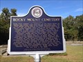 view gallery view galleryS13.4 km | Rocky Mount Cemetery - Millbrook, AL in Alabama Historical Markers This marker is located behind the fence surrounding the Rocy Mount Cemetery. posted by: xptwo location: Alabama date approved: 10/11/2014 last visited: never |
|