Sandtown Road orTennessee Road.- Allatoona GA
Posted by: Groundspeak Regular Member GA Cacher
N 34° 06.846 W 084° 42.919
16S E 710723 N 3777164
Allatoona Pass State Historical Marker Located on the Allatoona Rd. in Allatoona, Ga.
Waymark Code: WM29CQ
Location: Georgia, United States
Date Posted: 09/26/2007
Published By:Groundspeak Premium Member cosninocanines
Views: 105

One of the earliest roads in the northwestern portion of the state was named Sandtown Road. It ran from a town at Montgomery's Ferry on the Chattahoochee River to the southern end these Allatoona Mountains. Here the Alabama Road follows the top of the ridge to the west while a second thoroughfare bears left to Tennessee. While little visible evidence remains of the Alabama Road, the road to Tennessee is plainly visible.

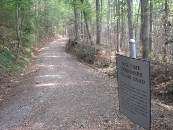
The small village of Allatoona had grown up just beyond the south entrance to the Pass. It consisted of the Clayton House, a railroad depot and 4 to 5 other structures. The old Tennessee wagon road, also known as the Sandtown Road, intersected the old Alabama Road at this point.Read the entire story here.
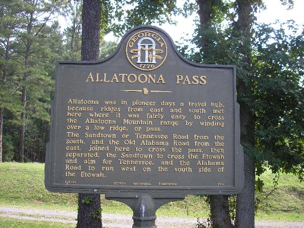
 Marker text reads: Allatoona was in pioneer days a travel hub, because ridges from east and south met here where it was fairly easy to cross the Allatoona Mountain range by winding over a low ridge, or pass. The Sandtown or Tennessee Road from the south, and the Old Alabama Road from the east, joined here to cross the pass, then separated, the Sandtown to cross the Etowah and aim for Tennessee, and the Alabama Road to run west on the south side of the Etowah. 008-44 GEORGIA HISTORICAL COMMISSION 1956 A major battle was fought here at Alatoona you can see the waymark here. Battle of Alatoona.

Road of Trail Name: Sandtown Rd and Tennessee RD

State: Georgia

County: Cherokee

Historical Significance:
Hernando Desoto visited this area in 1540 and met with the Cherokee indians. Major trail route for the Cherokeee Indians then the White Man,then a Civil War Supply road and a battle ground.


Years in use: started as a Cherokee Indian trail, first White man Hernando Desoto 1540

How you discovered it:
Part of the historic Alatoona Battle Ground and I found these markers while hiking the trail.


Website Explination:
http://georgiatrails.com/trails/allatoona.html


Why?:
This was a hub area for people and goods traveling south from Chattanooga TN, down to Atlanta and then to Alabama. This was then a major supply route for the Confederate and Union Troops.


Directions:
I-75 just North of Atlanta take the Emerson Exit go east on Old Allatoona Road 1.5 miles. http://maps.google.com/maps?q=34.114217+-84.715617


Book on Wagon Road or Trial: Not listed

Visit Instructions:
To post a log for this Waymark the poster must have a picture of either themselves, GPSr, or mascot. People in the picture with information about the waymark are preferred. If the waymarker can not be in the picture a picture of their GPSr or mascot will qualify. There are no exceptions to this rule.

Search for...
Geocaching.com Google Map
Google Maps
MapQuest
Bing Maps
Nearest Waymarks
Nearest Wagon Roads and Trails
Nearest Geocaches
Create a scavenger hunt using this waymark as the center point
Recent Visits/Logs:
Date Logged Log User Rating  
busterang visited Sandtown Road orTennessee Road.- Allatoona GA 12/26/2009 busterang visited it
Lat34North visited Sandtown Road orTennessee Road.- Allatoona GA 04/30/2008 Lat34North visited it
GA Cacher visited Sandtown Road orTennessee Road.- Allatoona GA 09/27/2007 GA Cacher visited it

View all visits/logs