 view gallery view gallery NE5.3 km NE5.3 km
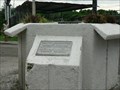
|   Centro Geografico de la Republica de Panama Centro Geografico de la Republica de Panama
in Geographical Centers This point is the Geographical Center of the Republic of Panama posted by:  ichivy ichivy location: Panama date approved: 07/31/2006 last visited: 08/13/2010 |
 view gallery view gallery E31.2 km E31.2 km
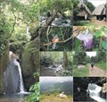
|  El Valle's Hot Springs, El Valle de Anton, Panama El Valle's Hot Springs, El Valle de Anton, Panama
in Hot Springs The Therapeutic Waters Of El Valle's Hot Springs, El Valle de Anton, Panama posted by:  Lucky_Al Lucky_Al location: Panama date approved: 03/29/2018 last visited: 03/22/2018 |
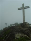
 view gallery view galleryE41.7 km |  Cerro Picacho Cerro Picacho
in Mountain Summits The "Cerro Picacho" (English: Peak Mountain) is located in the western side of the province of Panama, in the district of San Carlos. posted by: aj-8-52 location: Panama date approved: 04/30/2007 last visited: never |
 view gallery view galleryNE43.5 km | Cerro Negro in Mountain Summits The "Cerro Negro" (English: Black Mountain) is located in the western side of the province of Panama, in the district of Capira, at the border of the Altos de Campana National Park. posted by: aj-8-52 location: Panama date approved: 03/26/2010 last visited: never |
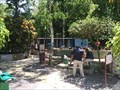
 view gallery view galleryNE46.2 km |  Eco-refugio Peña Blanca Eco-refugio Peña Blanca
in Campgrounds The eco-refuge offers potable water, 2 huts, open kitchen, latrine and shower. Visitors receive the added value of the beautiful Ciri river with fresh and crystalline waters, next to the location. posted by: aj-8-52 location: Panama date approved: 01/31/2007 last visited: never |
 view gallery view galleryE56.6 km |  Chiseled in Stone Chiseled in Stone
in Pictographs Located just off the PanAmerican Highway in a farmers field The farmer outlines the incised grooves (contrary to archeologists advice) to make them more visible. posted by: BLACKSTACK location: Panama date approved: 11/02/2005 last visited: never |
 view gallery view galleryE57.1 km | Cerro La Cruz in Mountain Summits The "Cerro La Cruz" (English: Cross Mountain) is located in the western side of the province of Panama, at the "Altos de Campana" National Park, first of its kind, created by law in 1966. posted by: aj-8-52 location: Panama date approved: 08/16/2007 last visited: never |
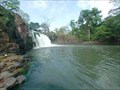 view gallery view galleryNE82.4 km |  El Chorro El Chorro
in Waterfalls The famous waterfall that gives name to La Chorrera city. posted by: aj-8-52 location: Panama date approved: 09/27/2006 last visited: 08/23/2009 |
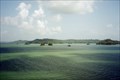 view gallery view galleryNE98.3 km |  Gatun structure - Panama Gatun structure - Panama
in Impact Craters Gatun structure discovered in 1972 by geologist Bob Stewart and estimate the original diameter to have been 2.7 to 3 km. posted by: kJfishman location: Panama date approved: 02/05/2016 last visited: 11/19/2017 |
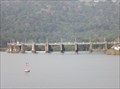 view gallery view galleryNE99.3 km |  Gatun Dam - Gatun Lake, Panama Gatun Dam - Gatun Lake, Panama
in Water Dams This dam was constructed on the Charges River between 1907 and 1913 in order to create Lake Gatun which is an essential part of the Panama Canal. posted by: PeterNoG location: Panama date approved: 08/19/2014 last visited: 04/04/2017 |
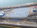 view gallery view galleryNE99.9 km |  Roundtable - Gatun Locks, Panama Roundtable - Gatun Locks, Panama
in Railway Roundhouses This Roundtable gets frequent use at the Gutan Locks at the northern entrance to the Panama Canal. posted by: PeterNoG location: Panama date approved: 08/15/2014 last visited: 12/28/2009 |
 view gallery view galleryNE100.3 km |  Paramedic Station - Gatun Locks, Panama Paramedic Station - Gatun Locks, Panama
in Paramedic Stations This Paramedic Station is on the west side of the Gutan Locks at the northern entrance to the Panama Canal. posted by: PeterNoG location: Panama date approved: 08/12/2014 last visited: 04/03/2017 |
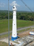 view gallery view galleryNE100.6 km |  Lighthouse - Gatun Locks, Panama Lighthouse - Gatun Locks, Panama
in Coastal Lighthouses This lighthouse is on the west side of Gutan Locks at the northern entrance to the Panama Canal in Panama. posted by: PeterNoG location: Panama date approved: 08/12/2014 last visited: 11/19/2017 |
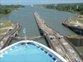
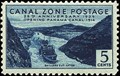
 view gallery view galleryNE100.7 km |  Panama Canal and Lighthouse. Panama Canal and Lighthouse.
in Waterway Locks, Planes and Lifts The Panama Canal is a fantastic illustration of engineering saving months of time by connecting the Atlantic Ocean to the Pacific Ocean. posted by: THE CAT location: Panama date approved: 08/28/2015 last visited: 02/16/2022 |
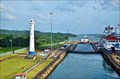
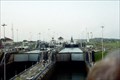
 view gallery view galleryNE100.7 km |  Gatun Locks - Panama Canal, Panama Gatun Locks - Panama Canal, Panama
in Philatelic Photographs The Gatun Locks are the northernmost set of locks on the Panama Canal. They are located six miles (10 km) south of the city of Colon, Panama. posted by:  neoc1 neoc1 location: Panama date approved: 03/30/2015 last visited: 12/28/2009 |
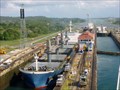 view gallery view galleryNE100.7 km |  Gatun Locks - Colon, Panama Gatun Locks - Colon, Panama
in Satellite Imagery Oddities The Gatun Locks are the northernmost set of locks on the Panama Canal. They are located six miles (10 km) south of the city of Colon, Panama. posted by: neoc1 location: Panama date approved: 04/03/2017 last visited: 12/28/2009 |
 view gallery view galleryNE101.2 km |  Swing Bridge - Gatun Locks - Panama Swing Bridge - Gatun Locks - Panama
in Moving Bridges There are two Moving Bridges across the Gatun Locks in Panama. This is the only crossing north of Lake Gatun in Panama. posted by: PeterNoG location: Panama date approved: 03/03/2012 last visited: 02/16/2022 |
 view gallery view galleryNE101.7 km | Panama Canal Gatun locks in Waterway Locks, Planes and Lifts Panama Canal Gatun locks posted by: kJfishman location: Panama date approved: 12/18/2007 last visited: 02/16/2022 |
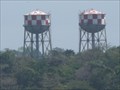 view gallery view galleryNE101.7 km |  Twin Water Towers - Gatun Locks, Panama Twin Water Towers - Gatun Locks, Panama
in Water Towers These twin Water Towers are about 1.3 km east of Gutan Locks in Panama. posted by: PeterNoG location: Panama date approved: 05/23/2014 last visited: 02/16/2022 |
 view gallery view galleryNE101.9 km | Lighthouse - N of Gatun Locks, Panama in Coastal Lighthouses This lighthouse is just north of and on the east side of Gutan Locks at the northern entrance to the Panama Canal in Panama. posted by: PeterNoG location: Panama date approved: 08/12/2014 last visited: 02/16/2022 |
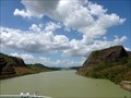 view gallery view galleryNE102.7 km |  Culebra Cut - Panama Canal, Panama Culebra Cut - Panama Canal, Panama
in Wikipedia Entries The Culebra Cut, once called the Gaillard Cut, is an artificial waterway created by cutting through the the Isthmus of Panama at the continental divide. posted by: neoc1 location: Panama date approved: 01/13/2019 last visited: never |
 view gallery view galleryNE102.7 km | Culebra (Gaillard) Cut - Panama Canal, Panama in Philatelic Photographs The Culebra Cut, once called the Gaillard Cut, is an artificial waterway created by cutting through the the Isthmus of Panama at the continental divide. posted by: neoc1 location: Panama date approved: 03/30/2015 last visited: 12/29/2009 |
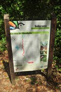 view gallery view galleryNE102.8 km |  Camino del Oleoduto - Gamboa, Panama Camino del Oleoduto - Gamboa, Panama
in Hiking and walking trailheads The Camino del Oleoduto (Pipeline trail) is a classic hiking train in the Parque Nacional Soberania, in Panama. posted by: Torgut location: Panama date approved: 03/13/2016 last visited: never |
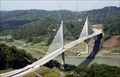 view gallery view galleryNE103 km | Puente Centenario in Suspension Bridges Centennial Bridge (Spanish: Puente Centenario) is a major bridge crossing the Panama Canal, and hence connecting North and South America. It was built to supplement the overcrowded Bridge of the Americas (Waymark code: WMJ21). posted by: aj-8-52 location: Panama date approved: 11/30/2006 last visited: 10/25/2008 |
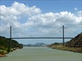 view gallery view galleryNE103 km | Centennial Bridge - Panama Canal, Panama in Wikipedia Entries Centennial Bridge (Puente Centenario) is a cable stay suspension bridge over the Panama Canal. It is located at the Culebra Cut about the 8 miles from the Pacific Ocean. posted by: neoc1 location: Panama date approved: 01/16/2018 last visited: 12/29/2009 |
|