 view gallery view gallery SW15.3 km SW15.3 km
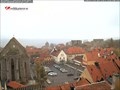
|   Visby cam Visby cam
in Web Cameras A nice little webcam on our Big Square in Visby. posted by:  Tadetlugnt Tadetlugnt location: Gotland, Sweden date approved: 11/09/2015 last visited: 07/24/2022 |
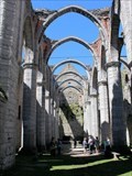
 view gallery view gallerySW15.3 km |  St. Karin (Visby) - Visby, Gotland, Sweden St. Karin (Visby) - Visby, Gotland, Sweden
in Wikipedia Entries DE: Artikel über die Kirchenruine St. Karin in Visby.
EN: Article page on the church ruin St. Karin in Visby. posted by: FamilieFrohne location: Gotland, Sweden date approved: 05/10/2022 last visited: 07/24/2022 |
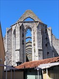
 view gallery view gallerySW15.3 km |  St. Karin kyrkoruin - Visby, Gotland, Sweden St. Karin kyrkoruin - Visby, Gotland, Sweden
in Preserved Architectural Remnants and Ruins The ruin of the church St. Karin is located in Visby on Gotland. posted by: FamilieFrohne location: Gotland, Sweden date approved: 05/10/2022 last visited: 07/24/2022 |
 view gallery view gallerySW15.4 km |  Tjernobyleken - Visby, Gotland Tjernobyleken - Visby, Gotland
in Disaster Memorials Tjernobyleken aka Chernobyl oak in Almedalen park Visby. posted by: small oaks location: Gotland, Sweden date approved: 03/05/2010 last visited: 07/23/2022 |
 view gallery view gallery NE52.8 km NE52.8 km
|  Langhammars - Farö, Gotland, Sweden Langhammars - Farö, Gotland, Sweden
in Drawing Waymarks One of the rauks in Langhammars Nature reserve on Gotland. posted by: FamilieFrohne location: Gotland, Sweden date approved: 05/05/2022 last visited: never |
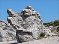
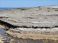
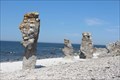 view gallery view galleryNE52.8 km |  Raukar near Langhammars - Gotland, Sweden Raukar near Langhammars - Gotland, Sweden
in Places of Geologic Significance The limestone pillars called raukar are found in the Baltic Sea area on the shores of Gotland and Öland and in northern Norway. Some particularly fine specimens can be found at Langhammars in northern Gotland. posted by: FamilieFrohne location: Gotland, Sweden date approved: 05/05/2022 last visited: never |
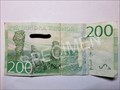 view gallery view galleryNE52.8 km |  Raukar near Langhammars - Farö, Gotland, Sweden Raukar near Langhammars - Farö, Gotland, Sweden
in Numismatic Photographs The 200 crowns bank note has the rauks of Farö on its back side. posted by: FamilieFrohne location: Gotland, Sweden date approved: 08/26/2022 last visited: never |
 view gallery view galleryNE52.8 km | Langhammars - Farö, Gotland, Sweden in Wikipedia Entries Article on the nature reserve and dwelling of Langhammar on Farö, an island north of Gotland. posted by: FamilieFrohne location: Gotland, Sweden date approved: 05/02/2022 last visited: 07/15/2023 |
 view gallery view galleryNE52.8 km |  Langhammars - Fårö, Gotlands Län, Sweden Langhammars - Fårö, Gotlands Län, Sweden
in Official Local Tourism Attractions The limestone pillars are found in the Baltic Sea area on the shores of Gotland (and also on Öland and in northern Norway). Some particularly fine specimens can be found at Langhammars in northern Gotland. posted by: FamilieFrohne location: Gotland, Sweden date approved: 01/11/2024 last visited: never |
 view gallery view galleryNE52.8 km |  Dogs Head - Farö, Gotland, Sweden Dogs Head - Farö, Gotland, Sweden
in Simulacra There is also a dog's head hidden among the rauks of Langhammar on the small island Farö north of Gotland. posted by: FamilieFrohne location: Gotland, Sweden date approved: 05/08/2022 last visited: never |
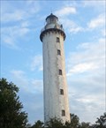
 view gallery view gallerySW59.2 km |  Lighthouse on Stora Karlsö - Stora Karlsö, Gotlands Län, Sweden Lighthouse on Stora Karlsö - Stora Karlsö, Gotlands Län, Sweden
in Coastal Lighthouses The lighthouse on the western edge of the island of Stora Karlsö was erected in 1887 and is still in use. posted by: FamilieFrohne location: Gotland, Sweden date approved: 05/07/2022 last visited: never |
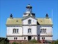 view gallery view gallerySW59.2 km |  Stora Karlsö Fyrhus Stora Karlsö Fyrhus
in Nordic Heritage The lighthouse on the western edge of the island of Stora Karlsö was build in 1886/1887 and is still in use. posted by: FamilieFrohne location: Gotland, Sweden date approved: 12/30/2022 last visited: never |
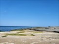
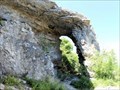 view gallery view gallerySW59.2 km |  Hässelby läde - Stora Karlsö, Gotlands Län, Sweden Hässelby läde - Stora Karlsö, Gotlands Län, Sweden
in Natural Arches Hässelby läde is an approximately 9m high stone arch located on the protected island of Stora Karlsö near Gotland. posted by: FamilieFrohne location: Gotland, Sweden date approved: 05/08/2022 last visited: never |
 view gallery view gallerySW89.5 km | Lighthouse Långe Erik - Öland, Sweden in Coastal Lighthouses Långe Erik ("Tall Erik") built in 1845 and located on a little island at the north cape of Öland. posted by:  turfilus turfilus location: Kalmar, Sweden date approved: 07/30/2013 last visited: 07/07/2023 |
 view gallery view gallerySW94.3 km | Neptuni Åkrar (Fields of Neptune) - Byxelkrok, Öland, Kalmar Län, Sweden in Official Local Tourism Attractions The Fields of Neptune are a popular day trip destination on the north of the island of Öland. posted by: FamilieFrohne location: Kalmar, Sweden date approved: 05/04/2022 last visited: 08/28/2023 |
 view gallery view gallerySW94.3 km | Neptun's Fields - Byxelkrok, Öland, Kalmar Län, Sweden in Wikipedia Entries Article on the coastal strip named Neptune's Field (Swedish: Neptuni åkrar) on the island of Öland near Byxelkrok. posted by: FamilieFrohne location: Kalmar, Sweden date approved: 05/01/2022 last visited: 08/28/2023 |
 view gallery view gallerySW94.3 km |  Neptuni Åkrar - Byxelkrok, Öland, Kalmar Län, Sweden Neptuni Åkrar - Byxelkrok, Öland, Kalmar Län, Sweden
in Paleontology and Fossils Fossils can be found on Neptune's Fields (Swedish: Neptuni åkrar) near Byxelkrok on Öland. posted by: FamilieFrohne location: Kalmar, Sweden date approved: 05/03/2022 last visited: 08/28/2023 |
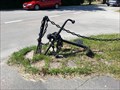
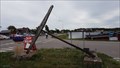 view gallery view gallerySW96.4 km |  Byxelkrok Anchor #1 Byxelkrok Anchor #1
in Anchors An anchor near Byxelkrok harbour posted by: llavids location: Kalmar, Sweden date approved: 07/21/2017 last visited: 08/28/2023 |
 view gallery view gallerySW107.3 km | Löttorp Anchor #1 in Anchors An anchor on display in Löttorp. posted by: llavids location: Kalmar, Sweden date approved: 07/15/2013 last visited: 08/28/2023 |
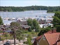 view gallery view gallery N128.7 km N128.7 km
| The Nynäs harbour in Web Cameras This web camera is a real time camera that overlooks the harbour in Nynäshamn posted by: Wickan location: Stockholm, Sweden date approved: 11/30/2009 last visited: 04/12/2015 |
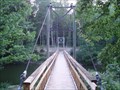 view gallery view gallery NW138.2 km NW138.2 km
|  Footbridge across Nyköpingsån Footbridge across Nyköpingsån
in Pedestrian Suspension Bridges A new suspension bridge, no more than 2 months old (photographed July 14, 2006) posted by: pewe location: Sweden date approved: 07/15/2006 last visited: 09/25/2015 |
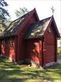 view gallery view galleryNW141.3 km |  Kapell - Sillekrog, Sweden Kapell - Sillekrog, Sweden
in Waychapels A small waychapel surrounded by trees at the rest area Silleskrog posted by: Walking Boots location: Södermanland, Sweden date approved: 09/29/2021 last visited: 05/01/2023 |
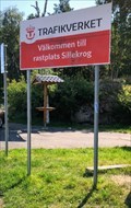 view gallery view galleryNW141.5 km |  E4 Rastplats Sillekrog - Tyrstberga, Sweden E4 Rastplats Sillekrog - Tyrstberga, Sweden
in Highway Rest Areas The Rest Area Sillekrog east on Highway E4 towards Stockholm has several times won the award as the Region's best Rest Area posted by: Walking Boots location: Södermanland, Sweden date approved: 09/04/2021 last visited: 05/01/2023 |
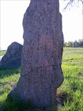
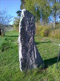 view gallery view galleryNW149.5 km |  Aspa bro, Södermanland Aspa bro, Södermanland
in Runestones Worldwide Two rune stones with carvings from the 11th century. Very close to the road that leads through the little village of Aspa. posted by: Hedenhöös location: Södermanland, Sweden date approved: 05/03/2011 last visited: 01/28/2017 |
 view gallery view galleryNW150.8 km | Korpbron, Södermanland - Sö. 139 & Sö. 140. in Runestones Worldwide Two rune stones from the 11th century in the parish of Ludgo, Södermanland. These stones are listed as Södermanlands Runstenar N:o 139 and 140. posted by: Hedenhöös location: Södermanland, Sweden date approved: 05/03/2011 last visited: 01/28/2017 |
|