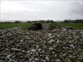
 view gallery view gallery N21.7 km N21.7 km
|   Cairn, Kilmartin Valley, Argyll, Scotland Cairn, Kilmartin Valley, Argyll, Scotland
in Cairns Nether Largie South Cairn in Kilmartin Valley in Argyll Scotland. posted by:  wldangel wldangel location: Southern Scotland, United Kingdom date approved: 01/23/2012 last visited: never |
 view gallery view galleryN22.9 km |  Kilmartin Museum - Kilmartin, Scotland Kilmartin Museum - Kilmartin, Scotland
in History Museums Visit Scotland's "richest prehistoric landscape!" posted by: DnRseekers location: Northern Scotland, United Kingdom date approved: 09/01/2014 last visited: 05/08/2014 |
 view gallery view gallery NE29.6 km NE29.6 km
|  WII-3 Strathlachlan WII-3 Strathlachlan
in Castles The original structure was built then and later replaced by a 15th century keep. The chief of the MacLachlans was killed at the Battle of Culloden in 1746. At that time, the castle was ravaged by the Campbells. posted by: Wayfarer II location: United Kingdom date approved: 10/11/2005 last visited: 06/29/2009 |
 view gallery view gallery SE29.6 km SE29.6 km
|  Hutton's Unconformity - Lochranza, Isle of Arran, UK Hutton's Unconformity - Lochranza, Isle of Arran, UK
in Places of Geologic Significance One of the most famous places in the study of geology and the history of the earth. James Hutton found evidence here that helped him develop his revolutionary theories about the earth, and which led to the modern science of geology. posted by: martlakes location: United Kingdom date approved: 03/28/2008 last visited: 07/24/2012 |
 view gallery view gallerySE29.8 km |  Sailor's Grave - Lochranza, Isle of Arran, UK Sailor's Grave - Lochranza, Isle of Arran, UK
in Out of Place Graves Along the raised shore on the north of the Isle of Arran lies this grave. As a suspected cholera victim he was refused burial in Lochranza churchyard. His resting place overlooks the Sound he no doubt sailed up. posted by: martlakes location: United Kingdom date approved: 03/29/2008 last visited: 07/29/2019 |
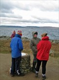 view gallery view gallerySE29.8 km |  Newton Point - Lochranza, Isle of Arran, UK Newton Point - Lochranza, Isle of Arran, UK
in Orientation Tables Newton Point is an interesting site for geologists and part of the coastal walk around Arran. It forms the NE side of Lochranza and provides an excellent view across the sound. A viewpoint has been established. posted by: martlakes location: United Kingdom date approved: 04/08/2008 last visited: 07/15/2012 |
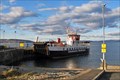 view gallery view gallerySE30.1 km |  Claonaig Ferry - Lochranza, Isle of Arran, Ayrshire, UK Claonaig Ferry - Lochranza, Isle of Arran, Ayrshire, UK
in Ferries and Ferry Landings Arran is a delightful island in the Firth of Clyde in SW Scotland. The main route is Ardrossan-Brodick, however, a useful small ferry runs from the north of the island across to the Kintyre peninsula. This makes for a great trip out to the west. posted by: martlakes location: Southern Scotland, United Kingdom date approved: 03/28/2008 last visited: 07/29/2019 |
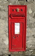 view gallery view gallerySE30.4 km |  Catacol Hotel Post Box - Isle of Arran, Ayrshire UK Catacol Hotel Post Box - Isle of Arran, Ayrshire UK
in Victorian Post Boxes A small ex-fishing village stands beside Catacol Bay and there is a hotel of the same name. Mounted within its roadside wall is this box. posted by: martlakes location: United Kingdom date approved: 03/26/2008 last visited: 07/31/2014 |
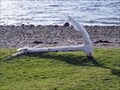 view gallery view gallerySE30.4 km |  Anchor - Catacol, Isle of Arran, Ayrshire UK Anchor - Catacol, Isle of Arran, Ayrshire UK
in Anchors A small, white anchor in Catacol on the Isle of Arran. Nearby is a line of houses built for the fishing village, and the Catacol Bay Hotel. posted by: martlakes location: United Kingdom date approved: 03/28/2008 last visited: 07/31/2014 |
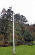 view gallery view gallerySE30.6 km |  Lochranza, Isle of Arran, UK Lochranza, Isle of Arran, UK
in Nautical Flag Poles A nautical flag pole in a private garden next to the road through the village. The house overlooks the loch and the castle. posted by: martlakes location: United Kingdom date approved: 03/25/2008 last visited: 07/29/2019 |
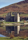 view gallery view gallerySE30.6 km | Lochranza Castle - Isle of Arran, Ayrshire UK in Castles A 13th century hallhouse converted into a towerhouse in the 15th century, abandoned by the 19th century. It sits on a shingle spit projecting into the bay, forming a focal point for the village. posted by: martlakes location: United Kingdom date approved: 04/24/2008 last visited: 07/29/2019 |
 view gallery view gallerySE32.2 km |  Mile 45 - Isle of Arran, Ayrshire UK Mile 45 - Isle of Arran, Ayrshire UK
in Milestones There are 55 milestones on the coast road around the island. This is number 45, just south of Lochranza in the north of the island. posted by: martlakes location: United Kingdom date approved: 04/07/2008 last visited: never |
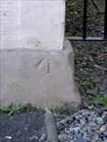
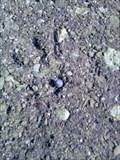
 view gallery view gallery E34.9 km E34.9 km
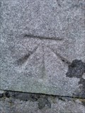
|  Cut Mark- Toward Castle, Toward. Cut Mark- Toward Castle, Toward.
in U.K. and Ireland Trigpoints A cut bench mark on Toward Castle on the A815 in Toward. posted by:  Dave_S+Net Dave_S+Net location: United Kingdom date approved: 10/09/2008 last visited: 07/30/2012 |
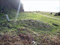
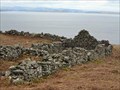 view gallery view gallerySE36 km |  Lagantuine - Isle of Arran, Ayrshire UK Lagantuine - Isle of Arran, Ayrshire UK
in Ghost Towns A deserted hamlet on the Isle of Arran. Its people were cleared off the land to make way for sheep in 1829. The inhabitants from here and other settlements in the north of the island were forced to leave for Canada. posted by: martlakes location: Southern Scotland, United Kingdom date approved: 03/28/2008 last visited: never |
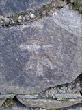
 view gallery view galleryE39.9 km | Cut Mark- Free Church, Argyll Street,Dunoon. in U.K. and Ireland Trigpoints A cut bench mark on the Free Church on the South West side of Argyll Street in Dunoon. posted by: Dave_S+Net location: United Kingdom date approved: 10/09/2008 last visited: 06/13/2014 |
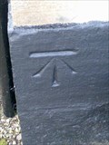
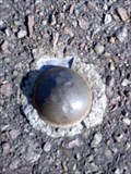 view gallery view galleryE40.1 km | NBM OSBM Bolt, Sea Wall,Dunoon in U.K. and Ireland Trigpoints A NBM OSBM bolt located on the sea wall just off the A815 in Dunoon. posted by: Dave_S+Net location: United Kingdom date approved: 10/09/2008 last visited: never |
 view gallery view galleryE40.1 km | NBM OSBM Bolt- Dunoon Jetty. in U.K. and Ireland Trigpoints A NBM OSBM bolt on Dunoon Jetty just off the A815 in Dunoon. posted by: Dave_S+Net location: United Kingdom date approved: 10/09/2008 last visited: never |
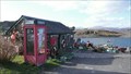
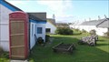 view gallery view galleryN40.2 km |  Easdale Island Telephone box Easdale Island Telephone box
in Red Telephone Boxes Easdale island has a museum which opened in 2008. Next to the museum is a classic red telephone box. There is no working 'phone in it. The nearest working payphone is at the harbour. posted by: flipflopnick location: Southern Scotland, United Kingdom date approved: 08/26/2009 last visited: never |
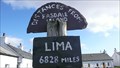 view gallery view galleryN40.2 km |  Easdale Island distances Easdale Island distances
in Direction and Distance Arrows Easdale island used to be many slate quarries. The village is separated by a narrow channel of water, served by a small passenger ferry. This post is next to the football 'pitch'. posted by: flipflopnick location: Southern Scotland, United Kingdom date approved: 08/26/2009 last visited: never |
 view gallery view galleryN40.2 km |  Easdale Harbour 'phone Easdale Harbour 'phone
in Payphones Easdale harbour is a grade 2 listed monument. The walls were rebuilt last century. The harbour is on a 50 year lease to the island community to look at regenerating the waste land around. The payphone is next to the ferry waiting room. posted by: flipflopnick location: Southern Scotland, United Kingdom date approved: 08/26/2009 last visited: never |
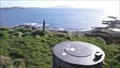 view gallery view galleryN40.4 km | Easdale Island Viewpoint in Orientation Tables Easdale Island used to be famous for the slate it exported. This view and table are on the high point of the rib remaining after the sides have been hewn away. posted by: flipflopnick location: Southern Scotland, United Kingdom date approved: 08/26/2009 last visited: never |
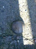
 view gallery view galleryE42.5 km | NBM OSBM Bolt- A880 South of Ardentinny. in U.K. and Ireland Trigpoints A NBM OSBM bolt on the A880 road, South of Ardentinny. posted by: Dave_S+Net location: United Kingdom date approved: 10/08/2008 last visited: never |
 view gallery view galleryE42.6 km | Rivet- A880 road,South of Ardentinny. in U.K. and Ireland Trigpoints A rivet on A880 road South of Ardentinny. posted by: Dave_S+Net location: United Kingdom date approved: 10/08/2008 last visited: never |
 view gallery view galleryE42.6 km | Cut Mark- Stone Wall, Ardentinny. in U.K. and Ireland Trigpoints A cut benchmark on a stone wall on the A880 in Ardentinny. posted by: Dave_S+Net location: United Kingdom date approved: 10/09/2008 last visited: never |
 view gallery view galleryE42.6 km | Cut Mark- Ardentinny Church, Ardentinny. in U.K. and Ireland Trigpoints A cut bench mark on Ardentinny Church on the West side of the A880 in Ardentinny. posted by: Dave_S+Net location: United Kingdom date approved: 10/08/2008 last visited: never |
|