 view gallery view gallery E5.6 km E5.6 km
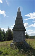
|   Covenanters monument, Bads Knowe, Dumfries, UK Covenanters monument, Bads Knowe, Dumfries, UK
in Obelisks A Covenanters' monument commemorating four Scottish Covenanters who were
shot here in 1685. The martyrs' graves are nearby. posted by:  neil_d neil_d location: Southern Scotland, United Kingdom date approved: 08/16/2011 last visited: never |
 view gallery view gallery W12.4 km W12.4 km
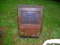
|  Kells Primary School Capsule at New Galloway Fire Station Kells Primary School Capsule at New Galloway Fire Station
in Time Capsules This capsule is outside New Galloway Fire station. posted by:  flipflopnick flipflopnick location: Southern Scotland, United Kingdom date approved: 06/29/2008 last visited: never |
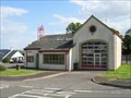 view gallery view galleryW12.4 km |  New Galloway Fire Station, Scotland New Galloway Fire Station, Scotland
in Firehouses New Galloway Fire Station is in West fire district of Dumfries and Galloway, Scotland. posted by: flipflopnick location: Southern Scotland, United Kingdom date approved: 06/29/2008 last visited: 06/25/2008 |
 view gallery view gallery S14.2 km S14.2 km
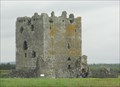
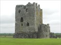
|  Threave Castle - Dumfries and Galloway, Scotland Threave Castle - Dumfries and Galloway, Scotland
in Wikipedia Entries Threave Castle is located on an island in the River Dee. The castle has a large 14th century tower that was built by Archibald the Grim, Lord of Galloway. posted by: Marine Biologist location: Southern Scotland, United Kingdom date approved: 06/29/2012 last visited: never |
 view gallery view galleryS14.2 km |  Threave Castle - Dumfries and Galloway, Scotland Threave Castle - Dumfries and Galloway, Scotland
in Castles Threave Castle is located on an island in the River Dee. The castle has a large 14th century tower that was built by Archibald the Grim, Lord of Galloway. posted by: Marine Biologist location: Southern Scotland, United Kingdom date approved: 06/29/2012 last visited: never |
 view gallery view galleryS14.2 km |  Threave Castle - Dumfries and Galloway, Scotland Threave Castle - Dumfries and Galloway, Scotland
in English Heritage - Cadw - Historic Scotland Threave Castle is located on an island in the River Dee. The castle has a large 14th century tower that was built by Archibald the Grim, Lord of Galloway. posted by: Marine Biologist location: Southern Scotland, United Kingdom date approved: 06/29/2012 last visited: never |
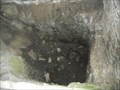 view gallery view galleryS14.2 km |  Threave Castle Well - Dumfries and Galloway, Scotland Threave Castle Well - Dumfries and Galloway, Scotland
in Draw Wells Threave Castle is located on an island in the River Dee. The well was situated inside the castle to resist siege. posted by: Marine Biologist location: Southern Scotland, United Kingdom date approved: 08/03/2015 last visited: never |
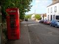
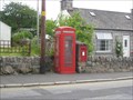 view gallery view galleryS14.8 km |  Dalbeattie, Dumfries and Galloway. UK Dalbeattie, Dumfries and Galloway. UK
in Red Telephone Boxes On the High Street in Dalbeattie, running south toward the A710. Kirkudbright Rd. posted by: thebigchip location: United Kingdom date approved: 07/07/2009 last visited: never |
 view gallery view gallery SE15.6 km SE15.6 km
| Beeswing, Dumfries and Galloway. UK in Red Telephone Boxes On the A711 in Beeswing. Dumfrieshire. Pretty tatty. posted by: thebigchip location: United Kingdom date approved: 07/07/2009 last visited: never |
 view gallery view gallerySE16.9 km |  St Peter's Church, Dalbeattie, Dumfries and Galloway St Peter's Church, Dalbeattie, Dumfries and Galloway
in This Old Church St Peter's Roman Catholic church is made from pinky granite with red sandstone dressings. Grey granite tower added c.1850. St Peter's is one of the oldest churches in Dalbeattie. posted by: flipflopnick location: Southern Scotland, United Kingdom date approved: 12/12/2007 last visited: 07/15/2008 |
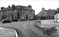
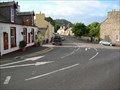
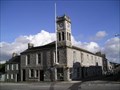 view gallery view gallerySE16.9 km |  Dalbeattie, Dumfries and Galloway - UK Dalbeattie, Dumfries and Galloway - UK
in City and Town Halls Dalbeattie is a town made from local grey granite, and town hall is no exception. Occupying a prominent position on the main crossroads in the town. posted by: flipflopnick location: Southern Scotland, United Kingdom date approved: 12/06/2007 last visited: 07/15/2008 |
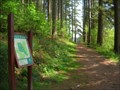
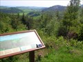 view gallery view galleryS19 km |  Doach Wood Viewpoint, Dumfries and Galloway Doach Wood Viewpoint, Dumfries and Galloway
in Scenic Overlooks Doach plantation is owned by the Forestry Commission and has two walks which both lead to this fine viewpoint, with seating and interpretive board. The view is south over Auchencairn Bay. posted by: flipflopnick location: Southern Scotland, United Kingdom date approved: 05/23/2008 last visited: 07/15/2008 |
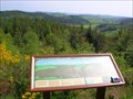 view gallery view galleryS19 km |  Doach Wood Viewpoint Map, Dumfries and Galloway Doach Wood Viewpoint Map, Dumfries and Galloway
in 'You Are Here' Maps Doach Wood viewpoint has an interpretive board detailing the view and a small map lest you forget where you are in the world. posted by: flipflopnick location: Southern Scotland, United Kingdom date approved: 05/23/2008 last visited: 07/15/2008 |
 view gallery view galleryS19 km | Doach Wood Parking area map, Dumfries and Galloway in 'You Are Here' Maps Doach Wood is owned by the Forestry Commission and there are two walks laid out. Both shown on this map. Just off the B736. posted by: flipflopnick location: Southern Scotland, United Kingdom date approved: 05/23/2008 last visited: 07/15/2008 |
 E19.3 km |  Twelve Apostles, Dumfries. Twelve Apostles, Dumfries.
in Megalithic Monuments The Twelve Apostles is a group of 11 stones, arranged in a circle in a field to the east of East Cluden Village. posted by: thebigchip location: United Kingdom date approved: 04/04/2008 last visited: 08/06/2006 |
 view gallery view galleryE20.1 km |  Mabie Forest Park Dumfries and Galloway Scotland Mabie Forest Park Dumfries and Galloway Scotland
in Mountain Bike Trailheads Mabie Forest Park is a working forest, with public mountain bike trails laid out. Very popular. Man made hazards on variety of single track surfaces. All testing, as well as less demanding regular forest roads. Free route maps. Maintained trails, with colour coded routes. posted by: flipflopnick location: Southern Scotland, United Kingdom date approved: 09/17/2006 last visited: 09/04/2006 |
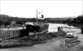 view gallery view galleryS20.6 km |  Palnackie Harbour, Dumfries and Galloway Palnackie Harbour, Dumfries and Galloway
in Photos Then and Now Palnackie harbour was built with wooden piles and planks around 1850. Only the boat appears to have changed. Looking north east on to the tidal Urr river. posted by: flipflopnick location: Southern Scotland, United Kingdom date approved: 07/11/2008 last visited: never |
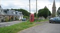
 view gallery view galleryS20.6 km | Port Road Red Telephone Box, Palnackie, Dumfries and Galloway in Red Telephone Boxes Port Road spurs down to the very small harbour in Palnackie. posted by: flipflopnick location: Southern Scotland, United Kingdom date approved: 07/11/2008 last visited: never |
 view gallery view galleryS20.6 km | The Old Post Office, Palnackie, Dumfries and Galloway in Photos Then and Now The former Post Office is now a private house. It is built of local grey granite, and stands on the outside of the main bend in the village. Looking south. posted by: flipflopnick location: Southern Scotland, United Kingdom date approved: 07/11/2008 last visited: never |
 view gallery view galleryS20.6 km | Palnackie in Wikipedia Entries Palnackie was on the main coastal road. Now the A711 takes the traffic past. Formerly a busy small port that has lost trade to railways and now road transport. See Nearby Waymarks. posted by: flipflopnick location: Southern Scotland, United Kingdom date approved: 07/11/2008 last visited: never |
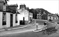 view gallery view galleryS20.6 km | Glen Isle Inn, Palnackie, Dumfries and Galloway in Photos Then and Now The Glen Isle Inn is on the inside of the main bend, opposite the Old Post Office. The A711 road now bypasses the village. Looking north. posted by: flipflopnick location: Southern Scotland, United Kingdom date approved: 07/11/2008 last visited: never |
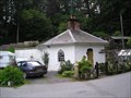 view gallery view galleryE20.9 km |  Dungowan, Mabie, Dumfries and Galloway UK Dungowan, Mabie, Dumfries and Galloway UK
in Octagon Buildings Dungowan is a private residence, painted white, looking like an old gate house at the entrance to Mabie Forest Park. Extension has been added as its a small building. posted by: flipflopnick location: Southern Scotland, United Kingdom date approved: 06/07/2007 last visited: never |
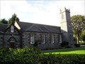
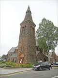
 view gallery view galleryE21.9 km | St. John's Church - Dumfries, Scotland in This Old Church St. John's Church is a Scottish Episcopal Church and thus a province of the world-wide Anglican Communion. It was constructed in 1868 and is located in Lovers' Walk in Dumfries. posted by: Marine Biologist location: Southern Scotland, United Kingdom date approved: 07/22/2012 last visited: never |
 view gallery view galleryE21.9 km |  St. John's Church - Dumfries, Scotland St. John's Church - Dumfries, Scotland
in Anglican and Episcopal Churches St. John's Church is a Scottish Episcopal Church and thus a province of the world-wide Anglican Communion. It was constructed in 1868 and is located in Lovers' Walk in Dumfries. posted by: Marine Biologist location: Southern Scotland, United Kingdom date approved: 07/22/2012 last visited: never |
 view gallery view galleryE21.9 km |  St. John's Church Bell Tower - Dumfries, Scotland St. John's Church Bell Tower - Dumfries, Scotland
in Bell Towers St. John's Church is a Scottish Episcopal Church was constructed in 1868 and is located in Lovers' Walk in Dumfries. posted by: Marine Biologist location: Southern Scotland, United Kingdom date approved: 07/22/2012 last visited: never |
|